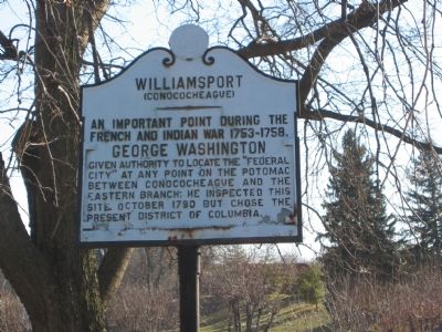
Williamsport in Washington County, Maryland — The American Northeast (Mid-Atlantic)
Williamsport
(Conococheague)
An important point during the French and Indian War 1753-1758.
Erected by State Roads Commission.
Topics. This historical marker is listed in these topic lists: Colonial Era • War, French and Indian • Waterways & Vessels. A significant historical month for this entry is October 1790.
Location. 39° 36.052′ N, 77° 49.03′ W. Marker is in Williamsport, Maryland, in Washington County. Marker is on E. Potomac Street (U.S. 11) 0.1 miles east of Williamsport Pike (Maryland Route 63), on the right when traveling east. Touch for map. Marker is in this post office area: Williamsport MD 21795, United States of America. Touch for directions.
Other nearby markers. At least 8 other markers are within walking distance of this marker. Band Stand (within shouting distance of this marker); Boy Scout Troop 17, 100 Years Old (within shouting distance of this marker); a different marker also named Williamsport (about 300 feet away, measured in a direct line); The Wagon Train of the Wounded and Williamsport (about 400 feet away); Confederate Hospitals in Williamsport (approx. 0.2 miles away); The Wagoner's Fight - July 6, 1863 (approx. 0.2 miles away); Springfield Farm (approx. 0.2 miles away); a different marker also named The Springfield Farm (approx. 0.2 miles away). Touch for a list and map of all markers in Williamsport.
Credits. This page was last revised on November 22, 2019. It was originally submitted on December 1, 2007, by F. Robby of Baltimore, Maryland. This page has been viewed 1,252 times since then and 9 times this year. Photo 1. submitted on December 1, 2007, by F. Robby of Baltimore, Maryland.
