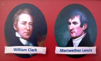
Near Lewis and Clark Village in Buchanan County, Missouri — The American Midwest (Upper Plains)
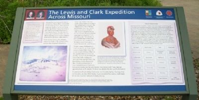
The Lewis and Clark Expedition Across Missouri
Inscription.
"Groops of Shrubs covered with the most delicious froot is to be seen in every direction, and nature appears to have exerted herself to butify the Senery by the variety of flours [flowers] Delicately and highly flavered raised above the Grass, which Strikes & profumes the Sensation, and amuses the mind."
William Clark, July 4, 1804
Although the boats were past the hardest stretch of the Missouri River - between the Grand and Kansas rivers - travel was by no means easy, thanks to the heat and strong current. Sgt. Charles Floyd wrote on July 3 that "water verry Strong So Hard that we Could Hardley Stem it." Two days later, the keelboat spun around three times, twice on shifting sand and once on a mass of floating driftwood that the French called embarras.
On the evening of July 4, 1804, the party camped at a stream on the west bank of the river that they christened Independence Creek. Capt. William Clark was struck with the beauty of the prairies that stretched away to the west. The campsite was in "one of the most butifull Plains, I ever Saw, open & butifully diversified with hills & vallies all presenting themselves to the river covered with grass and a few scattering trees a handsom Creek meandering thro." This mixture of grass (probably big bluestem) and scattered trees was characteristic of the tallgrass prairie landscape of western Missouri and eastern Kansas.
The July 4 camp at Independence Creek was also the site of an old and extensive Kansa Indian village, the second abandoned Kansa village site the expedition had seen in the last few days. To trade with the Kansa, the French had built a trading post, which the boats passed on July 3. Sgt. John Ordway noted in his journal that a French merchant from St. Louis founded the post. Clark wrote that near the trading post the party found a "verry fat and jentle" horse that had apparently been lost by Indians. The horse was added to the three used by the hunters.
To celebrate the Fourth of July, Clark wrote, "we Closed the day by a Discharge from our bow piece, an extra Gill of whiskey." A gill consisted of four ounces, which meant that the men received a half-pint of whiskey that day.
——————
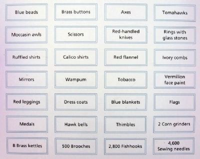
Indian Trade Goods
Carrying hundreds of pounds of Indian trade items for gifts and bartering, the Lewis and Clark Expedition expected to meet many Indian nations on the way to the Pacific Ocean. As laid out by President Thomas Jefferson, the expedition's mission was to befriend tribes, make peace among them and announce that with the purchase of Louisiana Territory, the American president was their new leader. In terms of commerce, the goal was to
lay a foundation for exclusive trade in furs with Indian tribes living within the Louisiana Territory. Reciprocal gift-giving was essential for good relations with Indians, and the expedition correctly anticipated that they would have to trade for food and other supplies. Lewis and Clark also needed to impress their future trading partners with the quality and quantity of their goods. Lewis bought most of the trade items in St. Louis and Philadelphia. In the end they fell short, as the expedition had little of value to offer in trade during the 1806 return to St. Louis.
Erected by Missouri Department of Natural Resources, National Park Service, and Missouri Lewis and Clark Bicentennial Commission.
Topics and series. This historical marker is listed in these topic lists: Environment • Exploration • Native Americans • Waterways & Vessels. In addition, it is included in the Lewis & Clark Expedition series list. A significant historical date for this entry is July 4, 1852.
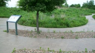
Location. 39° 32.119′ N, 95° 3.725′ W. Marker is near Lewis and Clark Village, Missouri, in Buchanan County. Marker can be reached from Lakeshore Drive. Marker is along the trail in the Lewis and Clark Expedition Interpretive Area of Lewis and Clark State Park, 801 Lakecrest Boulevard (Missouri Route 138), about
1.5 miles west of Missouri Routes 45/273. Touch for map. Marker is at or near this postal address: 1199 Lakeshore Dr, Rushville MO 64484, United States of America. Touch for directions.
Other nearby markers. At least 8 other markers are within 4 miles of this marker, measured as the crow flies. A different marker also named The Lewis and Clark Expedition Across Missouri (a few steps from this marker); Lewis and Clark in Missouri (a few steps from this marker); Atchison Veterans Memorial (approx. 3.3 miles away in Kansas); The Lewis and Clark Expedition (approx. 3.3 miles away in Kansas); Homeland of the Kanza Indians (approx. 3.3 miles away in Kansas); "walked on Shore above this Creek" (approx. 3.3 miles away in Kansas); "the water…contains a half…Glass of ooze" (approx. 3.3 miles away in Kansas); USS Arizona Memorial (approx. 3.3 miles away in Kansas). Touch for a list and map of all markers in Lewis and Clark Village.
Also see . . .
1. Lewis and Clark Across Missouri. Website homepage (Submitted on July 16, 2011, by William Fischer, Jr. of Scranton, Pennsylvania.)
2. Lewis and Clark in Missouri. Missouri Department of Conservation website entry (Submitted on July 16, 2011, by William Fischer, Jr. of Scranton, Pennsylvania.)
3. Lewis and Clark National Historic Trail. National Park Service website entry (Submitted on July 16, 2011, by William Fischer, Jr. of Scranton, Pennsylvania.)
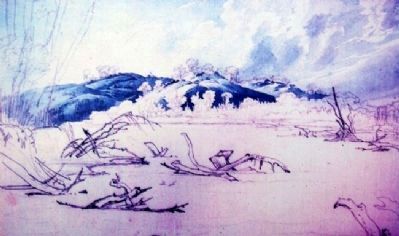
Photographed By Karl Bodmer, 1833
5. Sketch on The Lewis and Clark Expedition Across Missouri Marker
[Caption reads] This watercolor sketch of the Missouri River in the vicinity of Independence Creek, where the Lewis and Clark Expedition camped on July 4, 1804, was painted by Swiss artist Karl Bodmer in 1833. Snags, one of the many obstacles that plagued rivermen, can be seen in the foreground of the sketch.
Courtesy of the Joslyn Museum
Courtesy of the Joslyn Museum
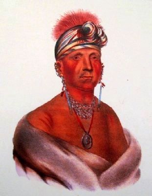
Photographed By McKenney and Hall, undated
6. Portrait on The Lewis and Clark Expedition Across Missouri Marker
[Caption reads] Once the Lewis and Clark Expedition passed the mouth of the Kansas River, they began to encounter the abandoned village sites of the Kansa Indians, who had once lived on the Missouri River. They were living on the Kansas River and hunting on the prairies at the time the expedition passed. This portrait of Monchonsia, a Kansa chief, is from McKenney and Hall, The Indian Tribes of North America.
Used with permission, State Historical Society of Missouri, Columbia
Used with permission, State Historical Society of Missouri, Columbia
Credits. This page was last revised on May 26, 2022. It was originally submitted on July 15, 2011, by William Fischer, Jr. of Scranton, Pennsylvania. This page has been viewed 1,139 times since then and 25 times this year. Photos: 1, 2, 3, 4, 5, 6. submitted on July 16, 2011, by William Fischer, Jr. of Scranton, Pennsylvania.
