Chadron in Dawes County, Nebraska — The American Midwest (Upper Plains)
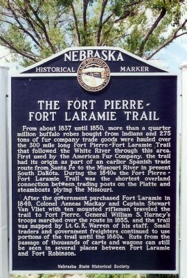
The Fort Pierre-Fort Laramie Trail
After the government purchased Fort Laramie in 1849, Colonel Aeneas Mackay and Captain Stewart Van Vliet with ten mounted riflemen traveled the trail to Fort Pierre. General William S. Harney's troops marched over the route in 1855, and the trail was mapped by Lt. G. K. Warren of his staff. Small traders and government freighters continued to use portions of the trail until the 1880s. Ruts from the passage of thousands of carts and wagons can still be seen in several places between Fort Laramie and Fort Robinson.
Erected by Nebraska State Historical Society. (Marker Number 304.)
Topics and series. This historical marker is listed in these topic lists: Exploration • Forts and Castles • Native Americans • Roads & Vehicles • Settlements & Settlers • Wars, US Indian. In addition, it is included in the Nebraska State Historical Society series list. A significant historical year for this entry is 1837.
Location. 42° 50.08′ N, 103° 4.02′ W. Marker is in Chadron, Nebraska, in Dawes County. Marker is on U.S. 385 near U.S. 20. Roadside park, west Jct. U.S. 385/U.S. 20. Touch for map. Marker is in this post office area: Chadron NE 69337, United States of America. Touch for directions.
Other nearby markers. At least 7 other markers are within 7 miles of this marker, measured as the crow flies. Fort Robinson - Camp Sheridan - Pine Ridge Indian Agency Road (approx. 2.9 miles away); Historic Northwestern Nebraska (approx. 2.9 miles away); The First Church in Chadron (approx. 3.3 miles away); The Chadron-Chicago Cowboy Race (approx. 3.4 miles away); Chadron State College (approx. 3˝ miles away); Bordeaux Trading Post (approx. 6˝ miles away); Chadron Creek Trading Post (approx. 6.7 miles away).
Related markers.
Click here for a list of markers that are related to this marker.
Additional commentary.
1. Gouverneur K. Warren
Mentioned On Marker, Warren later gained fame as a Major General in the Civil War. Known as the "Saviour of Little Round Top" at Gettysburg for his efforts to stave off disaster at that important point in the battle, he went on to lead a corps of the Army of the Potomac at Bristoe Station, Mine Run, and the Overland Campaign of 1864. His service ended somewhat ingloriously, when relieved in the closing days of the war at the Battle of Five Forks.
— Submitted January 4, 2008, by Mike Stroud of Bluffton, South Carolina.
Credits. This page was last revised on June 16, 2016. It was originally submitted on January 4, 2008, by Mike Stroud of Bluffton, South Carolina. This page has been viewed 2,386 times since then and 21 times this year. Photos: 1, 2, 3. submitted on January 4, 2008, by Mike Stroud of Bluffton, South Carolina. • Craig Swain was the editor who published this page.


