Fort Washington in Prince George's County, Maryland — The American Northeast (Mid-Atlantic)
The Potomac Highway
Oxon Cove Park
Photographed by Richard E. Miller, October 22, 2011
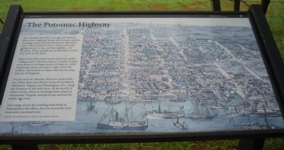
1. The Potomac Highway Marker
Two hundred and fifty years ago, the Potomac River was a highway. Roads were bumpy, narrow, winding routes, littered with stumps and fallen trees. They led from tobacco barns and small villages down to the real thoroughfare – the Potomac. When people and goods had to travel, they took to the water.
Many of the first roads on dry land were called “rolling roads.” Farmers, slaves, or teams of oxen used them to roll huge barrels of tobacco, called hogsheads, down the water’s edge. There the tobacco was loaded on ships, often for the long journey to England.
People used the Potomac River for local travel, too. More than sixty ferries connected points in Maryland, Virginia, and Washington, D.C., along the Potomac by the mid-1800s. At the mouth of Oxon Creek, a ferry to the King Street wharf in Alexandria, Virginia, started in 1740 and ran for nearly 200 years.
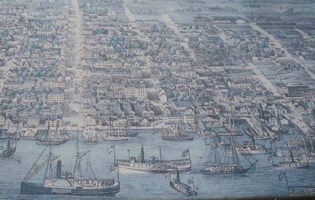
This image shows the bustling waterfront of Alexandria in the 1860s, directly across the river from where you stand now.
Birds Eye View of Alexandria, Va. Courtesy of The Mariner’s Museum.
Erected by National Park Service, U.S. Department of the Interior.
this page online
Topics. This historical marker is listed in these topic lists: Agriculture • Industry & Commerce • Roads & Vehicles • Waterways & Vessels. A significant historical year for this entry is 1740.
Location. 38° 48.184′ N, 77° 0.74′ W. Marker is in Fort Washington, Maryland, in Prince George's County. It is on Oxon Cove Trail near Bald Eagle Road. Marker is in Oxon Cove Park, on the north side of the hiker/biker trail in the woods northwest of the Oxon Hill Farm, overlooking the cove with I-295 and the Potomac River beyond. Touch for map. Marker is at or near this postal address: 6411 Oxon Hill Road, Oxon Hill MD 20745, United States of America. Touch for directions.

Regionally, this marker is in the Washington Metropolitan Area. It is also in the American South, specifically in the Upper South, in the Mid-Atlantic, and on the Eastern Seaboard. Globally, it is in the North Atlantic Region, North America, the Western Hemisphere, the Western World, and the Anglosphere. Historically, it finds itself in what was once one of the original Thirteen Colonies and also the Antebellum South.
Other nearby markers. At least
Photographed by Richard E. Miller, October 22, 2011
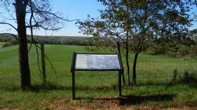
2. The Potomac Highway Marker - note the river and the Virginia shore
Also see . . . Oxon Cove Park and Oxon Hill Farm Hiker-Biker Trail. National Park Planner website entry (Submitted on March 10, 2022, by Larry Gertner of New York, New York.)
Photographed by Richard E. Miller, October 22, 2011
3. Close-up of The Potomac Highway Marker's "bird's-eye view" of the Alexandria waterfront
![Oxon Cove [Creek] off the Potomac River. Note the Anacostia Fwy (I-295) overpass image. Click for full size.](Photos1/178/Photo178990.jpg?3222020102200AM "Oxon Cove [Creek] off the Potomac River. Note the Anacostia Fwy (I-295) overpass. Click for full size.")
Photographed by Richard E. Miller, October 30, 2011
4. Oxon Cove [Creek] off the Potomac River. Note the Anacostia Fwy (I-295) overpass
Credits. This page was last revised on March 3, 2023. It was originally submitted on October 30, 2011, by Richard E. Miller of Oxon Hill, Maryland. This page has been viewed 760 times since then and 38 times this year. Photos: 1, 2, 3, 4. submitted on October 30, 2011, by Richard E. Miller of Oxon Hill, Maryland. • Bill Pfingsten was the editor who published this page.
