Bellevue in Campbell County, Kentucky — The American South (East South Central)
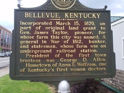
Bellevue, Kentucky
Erected 1970 by Kentucky Historical Society - Kentucky Department of Highways. (Marker Number 1351.)
Topics and series. This historical marker is listed in these topic lists: Abolition & Underground RR • Agriculture • Science & Medicine • Settlements & Settlers • Women. In addition, it is included in the Kentucky Historical Society series list. A significant historical date for this entry is March 15, 1859.
Location. 39° 6.137′ N, 84° 29.287′ W. Marker is in Bellevue, Kentucky, in Campbell County. Marker is on Fairfield Avenue (Kentucky Route 8) near Patchen Avenue, on the right when traveling east. On Fairfield Avenue between Riviera Drive and Patchen Avenue, in front of the Bellevue Veterans Club. Touch for map. Marker is at or near this postal address: 24 Fairfield Avenue, Bellevue KY 41073, United States of America. Touch for directions.
Other nearby markers. At least 8 other markers are within walking distance of this marker. Bellevue Landmark (approx. 0.4 miles away); Ohio’s First Publicly Owned Water System (approx. 0.4 miles away in Ohio); Toll House (approx. 0.4 miles away); General James Taylor Home (approx. half a mile away); The History Behind the Mt. Adams Steps Pathway (approx. half a mile away in Ohio); 315 3rd Street (approx. half a mile away); Mt. Adams (approx. half a mile away in Ohio); a different marker also named The History Behind the Mt. Adams Steps Pathway (approx. 0.6 miles away in Ohio). Touch for a list and map of all markers in Bellevue.
Credits. This page was last revised on September 17, 2020. It was originally submitted on November 3, 2011, by P. A. Miller of Richmond, California. This page has been viewed 1,124 times since then and 57 times this year. Photos: 1, 2. submitted on November 3, 2011, by P. A. Miller of Richmond, California. • Craig Swain was the editor who published this page.

