Wickliffe in Ballard County, Kentucky — The American South (East South Central)
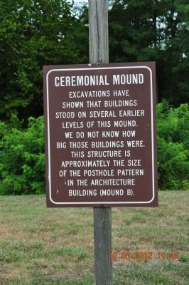
Ceremonial Mound
Topics. This historical marker is listed in these topic lists: Anthropology & Archaeology • Cemeteries & Burial Sites • Native Americans.
Location. 36° 58.26′ N, 89° 5.571′ W. Marker is in Wickliffe, Kentucky, in Ballard County. Marker can be reached from Green Street (U.S. 60) west of 1st Street, on the right when traveling west. Touch for map. Marker is at or near this postal address: 94 Green St, Wickliffe KY 42087, United States of America. Touch for directions.
Other nearby markers. At least 8 other markers are within walking distance of this marker. Welcome to Wickliffe Mounds (within shouting distance of this marker); King Mounds (within shouting distance of this marker); Burial Mound (about 300 feet away, measured in a direct line); The Prince of the French Explorers (about 400 feet away); Private First Class Robert Monroe Hammonds (approx. 0.4 miles away); County Named, 1842 (approx. 0.4 miles away); Lewis & Clark at Old Fort Jefferson (approx. 0.9 miles away); Fort Jefferson Memorial Cross at the Confluence (approx. 0.9 miles away). Touch for a list and map of all markers in Wickliffe.
Photographed By Sandra Hughes, August 12, 2012
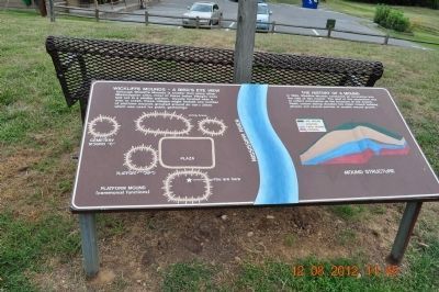
2. Wickliffe Mounds -A Birds Eye View
Although Wickliffe Mounds is smaller than many other Mississippian site, most of these Indian Villages were laid out in a similar pattern. Usually located near a river or creek,, these villages might include any number of platform mounds grouped around an open plaza which was used for public gatherings.
Photographed By Sandra Hughes, August 12, 2012
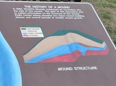
3. The History of a Mound
In 1984, Wickliffe Mounds conducted an excavation into the side of this mound. The goal of this excavation was to collect information on the structure of the mound. Radio carbon dating revealed two manor mound building phases and several periods of similar mounds growth.
Mound Structure.
Credits. This page was last revised on October 5, 2020. It was originally submitted on August 28, 2012, by Sandra Hughes Tidwell of Killen, Alabama, USA. This page has been viewed 745 times since then and 17 times this year. Photos: 1, 2, 3, 4, 5. submitted on August 28, 2012, by Sandra Hughes Tidwell of Killen, Alabama, USA. • Bernard Fisher was the editor who published this page.
