Near Welshpool in Charlotte County, New Brunswick — The Atlantic Provinces (North America)
Passamaquoddy Tribe / La Tribu Passamaquoddy
Inscription.
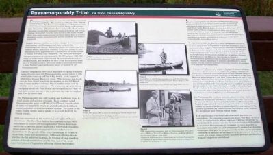
Passamaquoddy Bay takes its name from the Native American Passamaquoddy Tribe. The word means People of the Pollock-Spearing Place. The Passamaquoddy have a rich heritage, once occupying much of what is now eastern Maine and western New Brunswick. They lived inland, seasonally, where during the colder months they subsisted mainly by hunting and fishing. During the warmer months, they moved to the shore (where there were cooler temperatures and fewer biting flies) to harvest abundant marine resources such as fish, shellfish, and marine mammals.
Despite diseases, warfare, and other changes that accompanied first contact with Europeans and later settlers, the Passamaquoddy endure. Today, they have two reservations in eastern Maine, Sipayik at Pleasant Point near Eastport, and Motahkokmikuk, approximately 81 kilometres (50 miles) inland at Indian Township near Princeton. The tribe also manages natural resources on approximately 80,972 hectares (200,000 acres) of tribal lands. Sipayik and Motahkokmikuk are each self-governing, and each has its own Tribal Government made up of a Tribal Council, a Governor, and a Lieutenant Governor. A Joint Tribal Council addresses issues of concern to all Passamaquoddy.
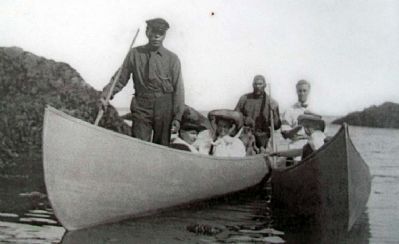
During Campobello's resort era, Campobello Company brochures spoke of canoe trips with Passamaquoddy guides (photo 1) who would pick clients up at Friar's Bay beach. In an August 7, 1916 letter, Eleanor Roosevelt wrote, "This morning was lovely and the first thing I saw from the window on the Pell Beach was a canoe and two Indians! We all bustled round and by 10:30 we were ready to start...The wind came up quite strong and going across the Duck Ponds and around Liberty Point we had quite a little sea but it was a glorious day and we reached Mill Cove by lunch time."
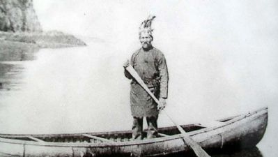
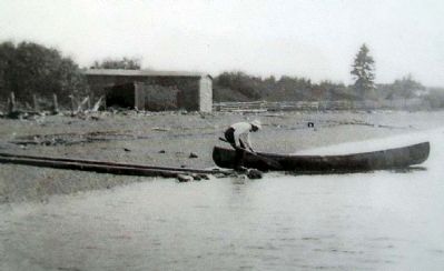
The Passamaquoddy also sold baskets and birchbark items to hotel guests and summer colonists. Each summer, noted Passamaquoddy artist and Tribal Chief Tomah Joseph (photo 2) came to Campobello where he guided and sold birchbark canoes and other artwork to summer visitors. The canoe in the Park's Visitor Centre (and in photo 3) was built for FDR by Tomah Joseph.
FDR was concerned for the well-being and rights of Native Americans. His New Deal Indian Reorganization Act (1934) was passed to restore self-management of Native American assets and to prevent further depletion of reservation resources. Other goals of the Act were to provide a sound economic foundation for the people of the reservations and to return to them local, tribal self-government. Although scholars debate whether the Act achieved its goals, its reversal of long-standing policies of forced assimilation marks it as one of the most important
pieces of legislation affecting Native Americans.
—————————
La baie Passamaquoddy doit son nom à la tribu amérindienne des Passamaquoddy. Son nom signifie "peuple qui pêche le poisson par l'entremise d'une lance". Les Passamaquoddy possèdent un riche patrimoine. La tribu occupaient autrefois une bonne partie de ce qui est aujourd'hui l'est de l'État du Maine et l'ouest de Nouveau-Brunswick. Durant les mois d'hiver, les membres de la tribu subsistaient principalement de la chasse et de la pêche. Lors des saisons plus clémentes, les membres de la tribu vivaient à l'intérieur des terres, près des rives pour profiter des températures plus fraîches, éviter les moustiques et récolter les produits de la mer, tels que les poissons, les crustacés et les mammifères marins.
De dépit de la maladie, des guerres et autres changements suivant les premiers contacts avec les Européens (et plus tard les premiers colons), les membres de la tribu des Passamaquoddy continuent d'occuper deux réserves dans l'est du Maine - Sipayik, située à la pointe Pleasant près de Eastport, et Motahkokmikuk, située à environ 81 km. (50 mi.) à l'intérieur des terres du Indian Township près de Princeton. La tribu fait l'exploitation de ressources naturelles sur un territoire d'environ 80,972 hectares (200,000 aces). Les réserves de Sipayik et Motahkokmikuk possèdent toutes les deux leur propre gouvernement autonome, conseil, gouverneur et lieutenant gouverneur. Un conseil conjoint s'occupe aussi des questions concernant l'ensemble des membres de la tribu des Passamaquoddy.
Á l'époque où l'affluence des visiteurs à Campobello battait son plein, les brochures publicitaires de la Campobello Company vantaient les plaisirs des voyages en canot guidés par les Passamaquoddy (photo 1). Ces derniers venaient chercher les clients sur la plage de la baie Friar. Dans une lettre rédigée le 7 août 1916, Eleanor Roosevelt écrit la note suivante: "Cette matinée est superbe et la première chose que j'ai remarqué en regardant par le fenêtre qui mène sur la plage Pell fut un canot et deux indiens! On s'est tous affairés et vers 10h30 nous étions prêts à partir...le vent s'éleva fortement et souffla à travers les Duck Ponds et autour de la pointe Liberty. Bien que la mer était assez mouvementée, nous avons néanmoins passé une journée glorieuse et nous sommes arrivés à Mill Cove avant le déjeuner."
Les Passamaquoddy vendaient aussi des paniers et autres articles faits d'écorce de bouleau aux habitants et visiteurs séjournant dans les hôtels. Chaque été, l'illustre artiste et chef de la tribu des Passamaquoddy, Tomah Joseph (photo 2) venait à Campobello où il servait de guide et vendait ses canots en bouleau et autres objets d'art aux visiteurs de l'île. Le canot à proximité du Centre d'accueil des visiteurs (et sur la photo 3) a été fabriqué pour FDR par Tomah Joseph.
FDR se préoccupait énormément du bien-être et des droits des amérindiens. Une composante importante de son "New Deal" fut la Loi sur la réorganisation des affairs indiennes (1934) qui fut adoptée en vue de rétablir la gestion autonome des biens amérindiens et d'empêcher la décimation des ressources sur la réserve. Un autre objectif de la nouvelle loi était d'offrir les outils nécessaires à la création d'une fondation économique solide pour les peuples amérindiens. Bien que les spécialistes continuent de débattre des bienfaits de la loi, personne ne conteste son apport à la remise en question des anciennes politiques pré-New Deal forçant l'intégration amérindiens.
—————————
Photo 1.
Franklin and Eleanor are in the canoe on the right.
Á droite, Franklin et Eleanor dans un canot.
Photo 2.
Pictured here is noted Passamaquoddy artist and Tribal Governor Tomah Joseph in one of his birchbark canoes. Friar's Head is in the background.
Sue cette photo, on voit l'illustre artiste et chef de la tribu Tomah Joseph à bord d'un de ses canots en bouleau. Á l'arrière plan, on aperçoit le cap Friar.
Photo 3.
In this 1907 photo, FDR is shown launching his Tomah Joseph-built canoe from the beach below his summer home.
Sue cette photo prise en 1907, on aperçoit FDR lors du lancement de son canot construit par Tomah Joseph sur la plage au bas de sa résidence d'été.
Photo 4.
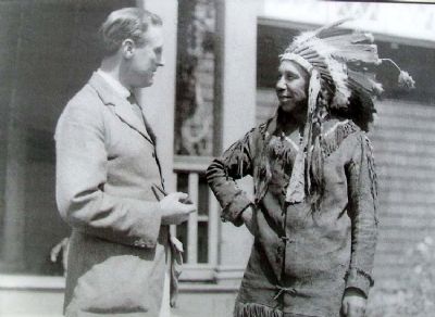
FDR continued his association with the Passamaquoddy. This photo shows FDR and Tribal Chief William Neptune speaking in front of the Roosevelt Cottage, circa 1920.
Cette photo de FDR témoigne de ses relations étroites avec la tribu des Passamaquoddy. Sur cette photo, on aperçoit FDR et le chef du tribu William Neptune en dialogue devant la résidence d'été de Roosevelt vers 1920.
Erected by Roosevelt Campobello International Park.
Topics and series. This historical marker is listed in these topic lists: Entertainment • Environment • Native Americans • Waterways & Vessels. In addition, it is included in the Eleanor Roosevelt, and the Former U.S. Presidents: #32 Franklin D. Roosevelt series lists. A significant historical year for this entry is 1916.
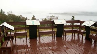
Location. 44° 52.575′ N, 66° 58.315′ W. Marker is near Welshpool, New Brunswick, in Charlotte County. Marker is at the Friar's Head/Cap Friars Observation Deck accessed off Provincial Road 774, about 0.7 miles west
of the main entrance to Roosevelt Campobello International Park. Touch for map. Marker is in this post office area: Welshpool NB E5E 1A4, Canada. Touch for directions.
Other nearby markers. At least 8 other markers are within walking distance of this marker. Roosevelt Campobello International Park (here, next to this marker); Mulholland Point / La Pointe Mulholland (here, next to this marker); Passamaquoddy Tidal Power Project (here, next to this marker); Friar's Head / Le Cap Friar (here, next to this marker); Campobello Company and Hotels (here, next to this marker); Panoramic View of Cottages (here, next to this marker); President Franklin Delano Roosevelt (approx. one kilometer away); Roosevelt Campobello Park (approx. one kilometer away). Touch for a list and map of all markers in Welshpool.
Also see . . . Passamaquoddy Tribe at Pleasant Point. Tribe website (Submitted on March 3, 2013, by William Fischer, Jr. of Scranton, Pennsylvania.)
Credits. This page was last revised on January 25, 2021. It was originally submitted on March 3, 2013, by William Fischer, Jr. of Scranton, Pennsylvania. This page has been viewed 1,201 times since then and 12 times this year. Photos: 1. submitted on March 3, 2013, by William Fischer, Jr. of Scranton, Pennsylvania. 2. submitted on March 2, 2013, by William Fischer, Jr. of Scranton, Pennsylvania. 3, 4, 5, 6. submitted on March 4, 2013, by William Fischer, Jr. of Scranton, Pennsylvania. 7. submitted on March 2, 2013, by William Fischer, Jr. of Scranton, Pennsylvania.
