Scott State Park in Scott County, Kansas — The American Midwest (Upper Plains)
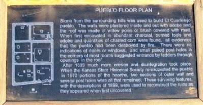
Pueblo Floor Plan
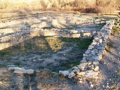
Stone from the surrounding hills was used to build El Cuartelejo pueblo. The walls were plastered inside and out with adobe and the roof was made of willow poles or brush covered with mud. When first excavated in abundant charcoal, burned tools and adobe and quantities of charred corn were found, all evidences that the pueblo had been destroyed by fire. There were no indications of doors or windows, and small paired post holes in the corners of most rooms suggested entrance by ladders through openings in the roof.
After 1899 much more erosion and disintegration took place. When the Kansas State Historical Society re-excavated the pueblo in 1970 portions of the hearths, two sections of outer wall and several post holes were all that remained. These surviving features, with the descriptions of 1899, were used to reconstruct the ruins as they appeared when first uncovered.
Topics. This historical marker is listed in these topic lists: Agriculture • Anthropology & Archaeology • Native Americans • Settlements & Settlers. A significant historical year for this entry is 1899.
Location. 38° 40.61′ N, 100° 54.899′ W. Marker is in Scott State Park, Kansas, in Scott County. Marker is adjacent to the ruins, at the end of the path from the parking lot on West Scott Lake Drive,. Touch for map. Marker is in this post office area: Scott City KS 67871, United States of America. Touch for directions.
Other nearby markers. At least 8 other markers are within 12 miles of this marker, measured as the crow flies. El Cuartelejo (a few steps from this marker); Plains Apache at El Cuartelejo (a few steps from this marker); El Cuartelejo Archeology (a few steps from this marker); El Quartelejo (within shouting distance of this marker); Steele Memorial (approx. ¼ mile away); Battle Canyon, 1878 (approx. 2.4 miles away); a different marker also named El Quartelejo (approx. 3.3 miles away); BOD (approx. 11.3 miles away). Touch for a list and map of all markers in Scott State Park.
Also see . . .
1. El Cuartelejo. Kansapedia entry (Submitted on June 13, 2013, by William Fischer, Jr. of Scranton, Pennsylvania.)
2. Western Vistas Historic Byway. Kansas Byways website entry (Submitted on April 26, 2021, by Larry Gertner of New York, New York.)
3. History of Scott State Park, Kansas. Kansas Department of Wildlife, Parks and Tourism website entry (Submitted on June 13, 2013, by William Fischer, Jr. of Scranton, Pennsylvania.)
Credits. This page was last revised on April 26, 2021. It was originally submitted on June 13, 2013, by William Fischer, Jr. of Scranton, Pennsylvania. This page has been viewed 505 times since then and 10 times this year. Photos: 1, 2. submitted on June 13, 2013, by William Fischer, Jr. of Scranton, Pennsylvania.

