Near Williamsburg in York County, Virginia — The American South (Mid-Atlantic)
Vineyard Tract
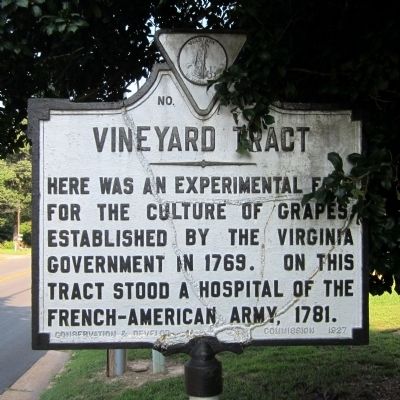
Photographed by Bernard Fisher, July 20, 2013
1. Vineyard Tract Marker
Erected 1927 by Conservation & Development Commission. (Marker Number W-46.)
Topics and series. This historical marker is listed in these topic lists: Agriculture • Colonial Era • War, US Revolutionary. In addition, it is included in the Virginia Department of Historic Resources (DHR) series list. A significant historical year for this entry is 1769.
Location. This marker has been replaced by another marker nearby. It was located near 37° 15.914′ N, 76° 40.033′ W. Marker was near Williamsburg, Virginia, in York County. It was on Penniman Road (Virginia Route 641) east of Vineyard Lane, on the right when traveling west. Touch for map. Marker was at or near this postal address: 1012 Penniman Rd, Williamsburg VA 23185, United States of America. Touch for directions.

Regionally, this marker was on Virginia’s Peninsula, in Coastal Virginia, and in the Hampton Roads Metropolitan Area. It was also in the American South, specifically in the
this page online
Other nearby markers. At least 8 other markers are within walking distance of this location: A different marker also named Vineyard Tract (here, next to this marker); Fort Magruder (about 500 feet away, measured in a direct line); a different marker also named Fort Magruder (about 500 feet away); Confederate Soldiers and Sailors Monument (about 500 feet away); Battle of Williamsburg (approx. half a mile away); Quarterpath Road (approx. 0.6 miles away); Peninsula Campaign (approx. 0.6 miles away); The Jersey Boys (approx. 0.6 miles away). Touch for a list and map of all markers in Williamsburg.
Another marker is no longer nearby. Magruder’s Defenses (was approx. half a mile away but has been confirmed missing).
Related marker. Click
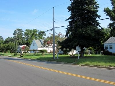
Photographed by Bernard Fisher, July 20, 2013
2. Vineyard Tract Marker
Credits. This page was last revised on October 9, 2022. It was originally submitted on July 21, 2013, by Bernard Fisher of Richmond, Virginia. This page has been viewed 1,048 times since then and 45 times this year. Photos: 1, 2. submitted on July 21, 2013, by Bernard Fisher of Richmond, Virginia.
