Near Pleasanton in Linn County, Kansas — The American Midwest (Upper Plains)
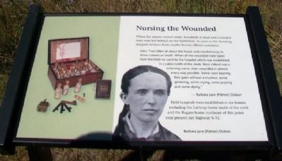
Nursing the Wounded
When the armies moved south, hundreds of dead and wounded men were left behind on the battlefield. As soon as the shooting stopped civilians from nearby homes offered assistance.
Men "had fallen all about the house and crawled away to fence corners or brush. When all the wounded were taken from the field we went to the hospital which was established in a cabin north of the creek. Here indeed was a sickening scene, men wounded in almost every way possible. Some were bearing their pain without a murmur, some groaning, some crying, some praying and some dying."
- Barbara Jane (Palmer) Dolson
Field hospitals were established in six homes including the Lathrop home south of the creek and the Ragain home northeast of this point near present day highway K-52.
[Image of] Barbara Jane (Palmer) Dolson
Erected 2012 by Kansas State Historical Society.
Topics. This historical marker is listed in these topic lists: Science & Medicine • War, US Civil • Women.
Location. 38° 8.538′ N, 94° 43.49′ W. Marker is near Pleasanton, Kansas, in Linn County. Marker is along the mowed trail, about 1200 feet SSW of the Mine Creek Civil War Battlefield State Historic Site Visitor Center. Touch for map. Marker is at or near this postal address: 20485 Kansas Highway 52, Pleasanton KS 66075, United States of America. Touch for directions.
Other nearby markers. At least 8 other markers are within walking distance of this marker. Conclusion of Price Campaign (within shouting distance of this marker); Union Charge (approx. 0.2 miles away); Cavalry (approx. 0.2 miles away); The Fort Scott Road (approx. 0.2 miles away); Two Mounted Armies Collide (approx. 0.2 miles away); The Battle Begins (approx. 0.2 miles away); Confederate Defeat (approx. 0.2 miles away); After the Battle (approx. 0.2 miles away). Touch for a list and map of all markers in Pleasanton.
Also see . . .
1. Mine Creek Battle. Kansapedia website entry (Submitted on October 20, 2014, by William Fischer, Jr. of Scranton, Pennsylvania.)
2. Mine Creek Civil War Battlefield. Kansas Historical Society website entry (Submitted on January 16, 2022, by Larry Gertner of New York, New York.)
Credits. This page was last revised on January 16, 2022. It was originally submitted on October 20, 2014, by William Fischer, Jr. of Scranton, Pennsylvania. This page has been viewed 460 times since then and 9 times this year. Photos: 1, 2. submitted on October 20, 2014, by William Fischer, Jr. of Scranton, Pennsylvania.

