Gainesville in Prince William County, Virginia — The American South (Mid-Atlantic)
Archeology at Brawner Farm
Photographed by J. Makali Bruton, September 4, 2015
1. Archeology at Brawner Farm Marker
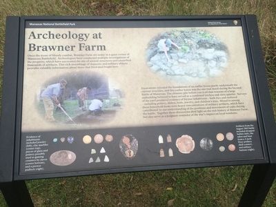
Once the scene of bloody combat, Brawner Farm sits today in a quiet corner of Manassas Battlefield. Archeologists have conducted multiple investigations of the property, which have uncovered the site of several structures and unearthed thousands of artifacts. This rich assemblage of domestic and military objects provides valuable information about those that lived and fought here.
Excavations revealed the foundations of an earlier house partly underneath the current structure, and this earlier house was the one that stood during the Second Battle of Manassas. The chimney pile before you is all that remains of a large outbuilding believed to have served as a combined kitchen and slave quarter. Surveys of the yard produced evidence of former inhabitants - both free and enslaved - including pottery, dishes, tools, jewelry, and children's toys. Mixed in among these household items were heavy concentrations of military artifacts, which have contributed to our understanding of the positions and movements of units during the battle. Together these discoveries shed light on the rich history of Brawner Farm, but also serve as a
this page online
Captions:
Evidence of inhabitants included jewelry (left), clay marbles (center top), pieces of glass and pottery possibly used as gaming counters by slaves (center bottom), and a prewar padlock (right).
Artifacts from the August 1862 battle included dropped bullets (left), the sabot and base from a 3-inch Dyer artillery shell (center), and military buttons (right).
Erected by National Park Service.
Topics. This historical marker is listed in these topic lists: Anthropology & Archaeology • Indigenous Peoples and Communities • War, US Civil. A significant historical month for this entry is August 1862.
Location. 38° 48.792′ N, 77° 33.936′ W. Marker is in Gainesville, Virginia, in Prince William County. It can be reached from Pageland Lane. The marker is directly before arriving at the Brawner Farm Interpretive Center. Touch for map. Marker is at or near this postal address: 6501 Pageland Ln, Gainesville VA 20155, United States of America. Touch for directions.

Regionally, this marker is in the Washington Metropolitan Area, in Northern Virginia, and in the Piedmont.
Photographed by J. Makali Bruton, September 4, 2015
2. Archeology at Brawner Farm Marker
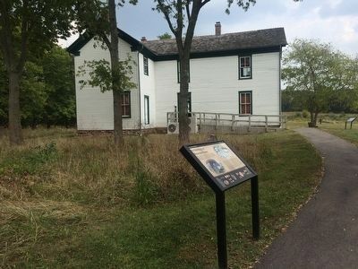
The Brawner Farm Interpretive Center is in the background. The chimney pile mentioned in the marker is directly in front of the marker where bits of rubble can be seen in the high grass.
Other nearby markers. At least 8 other markers are within walking distance of this marker: Jackson Opens Fire (within shouting distance of this marker); 19th Indiana Infantry (within shouting distance of this marker); A Stand Up Fight (within shouting distance of this marker); Jackson Strikes (about 300 feet away, measured in a direct line); 2nd Wisconsin Infantry (about 600 feet away); First Brigade (about 600 feet away); The Battle Begins (about 700 feet away); Shooting Gallery (about 700 feet away). Touch for a list and map of all markers in Gainesville.
Another marker is no longer nearby. Dying in Line (was within shouting distance of this marker but has been replaced with another marker now near it).
Credits. This page was last revised on April 9, 2022. It was originally submitted on September 11, 2015, by J. Makali Bruton of Washington, District of Columbia. This page has been viewed 951 times since then and 46 times this year. Photos: 1, 2. submitted on September 11, 2015, by J. Makali Bruton of Washington, District of Columbia.
