Hardeeville in Jasper County, South Carolina — The American South (South Atlantic)
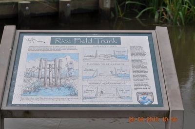
Rice Field Trunk
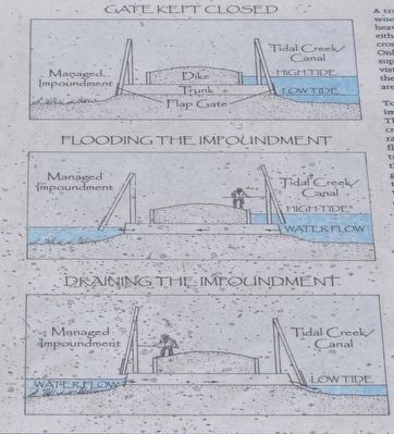
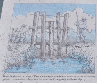
A trunk is a long wooden box with a heavy “flap gate” at either end. This dike crosses over the trunk. Only the gates and their support structures are visible. The gates facing the canal and the field are often kept closed.
To flood the nearby impounding: The trunk’s tide creek/canal side gate is raised. Raising tidewater flows through the trunk and forces open the opposite field-side gate, letting water into the impoundment. When the water reaches the preferred depth in the impoundment, the water pressure pushes the field-side door shut. Both gates are kept closed to hold water in the fields.
To drain the fields: The field-side gate is raised allowing water to drain out to the tidal creek/canal during low tide.
Erected by U.S. Fish & Wildlife Service, Department of the Interior.
Topics. This historical marker is listed in these topic lists: Agriculture • Environment • Man-Made Features.
Location. 32° 10.125′ N, 81° 6.792′ W. Marker is in Hardeeville, South Carolina, in Jasper County. Marker can be reached from the intersection of Laurel Hill Wildlife Drive and Alligator Alley (South Carolina Highway 170). Located in the Savannah National Wildlife Refuge. Touch for map. Marker is in this post office area: Hardeeville SC 29927, United States of America. Touch for directions.
Other nearby markers. At least 8 other markers are within 3 miles of this marker, measured as the crow flies. Managing Water for Wildlife (here, next to this marker); Prescribed Burning (here, next to this marker); Laurel Hill Plantation (approx. ¼ mile away); Using Fire to Benefit Wildlife (approx. ¼ mile away); Plantation Cistern (approx. one mile away); Savannah River Plantations (approx. 2.6 miles away in Georgia); Atlantic Coastal Highway Through Georgia (approx. 2.6 miles away in Georgia); Savannah Sugar Refinery Explosion (approx. 2.8 miles away in Georgia). Touch for a list and map of all markers in Hardeeville.

Photographed By Sandra Hughes, September 28, 2015
3. Gate kept closed- Dike -Trunk - Flap Gate
Managed Impoundment
Tidal Creek Canal
Hight Tide
Low tide
Flooding the Impoundment
Managed Impoundment
Tidal Creek/Canal
High Tide
Water Flow
Draining the Impoundment
Managed Impoundment
Water flow
Tidal Creek/Canal
Low Tide
Credits. This page was last revised on June 16, 2016. It was originally submitted on October 30, 2015, by Sandra Hughes Tidwell of Killen, Alabama, USA. This page has been viewed 805 times since then and 77 times this year. Photos: 1, 2, 3, 4. submitted on October 30, 2015, by Sandra Hughes Tidwell of Killen, Alabama, USA. • Bernard Fisher was the editor who published this page.
Editor’s want-list for this marker. A wide shot of the marker and its surroundings. • Can you help?


