Near Williamsburg in James City County, Virginia — The American South (Mid-Atlantic)
Paspahegh
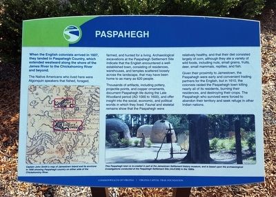
Thousands of artifacts, including pottery, projectile points, and copper ornaments, document Paspahegh life during the Late Woodland period (AD 1000 to 1600), and offer insight into the social, economic, and political worlds in which they lived. Faunal and skeletal remains show that the Paspahegh were relatively healthy, and that their diet consisted largely of corn, although they ate a variety of wild foods, including nuts, small grains, fruits, deer, small mammals, reptiles, and fish.
Given their proximity to Jamestown, the Paspahegh were early and convenient trading partners for the English, but in 1610, the colonists raided the Paspehegh town killing nearly all of its residents, burning their residences, and destroying their crops. The Paspahegh who survived were forced to abandon their territory and seek refuge in other Indian nations.
(captions)
Captain John Smith’s map of Jamestown Island and its environs in 1606 showing Paspahegh country on either side of the Chickahominy River.
This Paspahegh town is re-created in part at the Jamestown Settlement history museum, and is based upon the archaeological investigations conducted at the Paspahegh Settlement Site (44JC308) in the 1990s.
Erected by Virginia Capital Trail Foundation, Commonwealth of Virginia.
Topics. This historical marker is listed in these topic lists: Colonial Era • Native Americans • Settlements & Settlers. A significant historical year for this entry is 1607.
Location. 37° 15.917′ N, 76° 52.35′ W. Marker is near Williamsburg, Virginia, in James City County. Marker can be reached from John Tyler Memorial Highway (Virginia Route 5) 0.4 miles west of Barretts Ferry Drive, on the right when traveling west. Located in Chickahominy Riverfront Park. Touch for map. Marker is at or near this postal address: 1350 John Tyler Memorial Hwy, Williamsburg VA 23185, United States of America. Touch for directions.
Other nearby markers. At least 8 other markers are within 6 miles of this marker, measured as the crow flies. Wowinchapuncke (about 600 feet away, measured in a direct line); Piney Grove and E. A. Saunders (approx. 3.8 miles away); Paspahegh Indians (approx. 3.8 miles away); Sir William Berkeley (approx. 4.1 miles away); Bacon's Rebellion (approx. 4.7 miles away); Governor's Land (approx. 4.7 miles away); a different marker also named Governor’s Land (approx. 5.2 miles away); Green Spring Road (approx. 5.2 miles away). Touch for a list and map of all markers in Williamsburg.
Also see . . .
1. Paspahegh. Wikipedia (Submitted on November 9, 2021.)
2. Paspahegh Archaeological Site. National Register of Historic Places (Submitted on November 9, 2021.)
Credits. This page was last revised on November 11, 2023. It was originally submitted on November 25, 2015, by Bernard Fisher of Richmond, Virginia. This page has been viewed 464 times since then and 41 times this year. Photos: 1, 2. submitted on November 25, 2015, by Bernard Fisher of Richmond, Virginia.

