Marker Logo HMdb.org THE HISTORICAL
MARKER DATABASE
“Bite-Size Bits of Local, National, and Global History”
Westport in Baltimore, Maryland — The American Northeast (Mid-Atlantic)
 

Mount Auburn Cemetery


Mount Auburn Cemetery Marker image. Click for full size.
Photographed By Chris Nelson, February 1, 2003
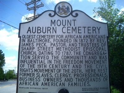
1. Mount Auburn Cemetery Marker
Inscription. Oldest cemetery for African Americans in Baltimore, founded in 1872 by Rev. James Peck, pastor, and trustees of Sharp Street Methodist Episcopal Church. Dating to 1787, the congregation served the community and was influential in the freedom movement of the 19th century and the civil rights movement of the 20th. Here rest former slaves, clergy, professionals, business owners and thousands of African American families.
 
Erected by Maryland Historical Trust, Maryland State Highway Administration.
 
Topics and series. This historical marker is listed in these topic lists: Abolition & Underground RRAfrican AmericansCemeteries & Burial SitesChurches & ReligionCivil Rights. In addition, it is included in the Maryland Historical Trust series list. A significant historical year for this entry is 1872.
 
Location. 39° 15.629′ N, 76° 38.212′ W. Marker is in Baltimore, Maryland. It is in Westport. Marker is on Waterview Avenue, 0 miles west of Annapolis Road (Maryland Route 648), on the right when traveling east. Touch for map. Marker is in this post office area: Baltimore MD 21230, United States of America. Touch for directions.
 
Other nearby markers. At least 8 other markers are within walking distance of this marker. Joseph Gans (about 600 feet away, measured in a direct line); Our Impact on Our Waters (approx. half a mile away); Senator Harry McGuirk
Paid Advertisement
Click on the ad for more information.
Please report objectionable advertising to the Editor.
Click or scan to see
this page online
(approx. 0.9 miles away); Gwynns Falls Trail (approx. one mile away); Carroll Park at the Golf Course (approx. one mile away); The Enduring Middle Branch (approx. one mile away); The Baltimore Ecosystem Study (approx. one mile away); Of Fords, Felles, and Falls (approx. one mile away). Touch for a list and map of all markers in Baltimore.
 
Mount Auburn Cemetery Marker image. Click for full size.
Photographed By Don Morfe, May 12, 2013
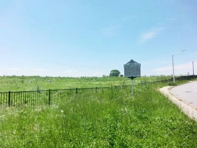
2. Mount Auburn Cemetery Marker
Wide shot of the cemetery marker showing the portion of the cemetery not yet cleaned up.
Mount Auburn Cemetery Marker image. Click for full size.
Photographed By Don Morfe, May 12, 2013
3. Mount Auburn Cemetery Marker
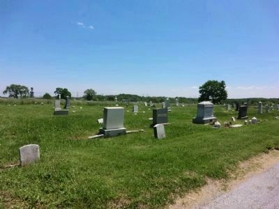
Photograph of the cemetery showing the portion that has been cleaned.
Joseph Gans Grave Site - Mount Auburn Cemetery image. Click for full size.
Photographed By Don Morfe, May 12, 2013
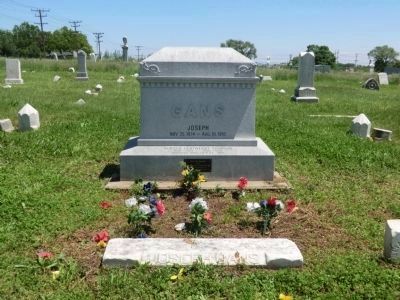
4. Joseph Gans Grave Site - Mount Auburn Cemetery
Joseph Gans was the Worlds Lightweight Boxing Champion for 1902-1904 and 1906-1908
Mount Auburn Cemetery Marker image. Click for full size.
Photographed By Don Morfe, May 12, 2013
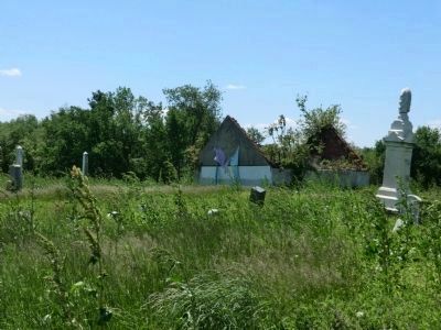
5. Mount Auburn Cemetery Marker
Portion of the cemetery not yet cleaned up.
 
 
Credits. This page was last revised on August 6, 2021. It was originally submitted on November 13, 2008, by Chris Nelson of Baltimore, Maryland. This page has been viewed 3,789 times since then and 23 times this year. Photos:   1. submitted on November 13, 2008, by Chris Nelson of Baltimore, Maryland.   2, 3, 4, 5. submitted on May 13, 2013, by Don Morfe of Baltimore, Maryland. • Bill Pfingsten was the editor who published this page.
Share this page.  
Share on Tumblr
m=13540

CeraNet Cloud Computing sponsors the Historical Marker Database.
This website earns income from purchases you make after using our links to Amazon.com. We appreciate your support.
Paid Advertisement
Apr. 25, 2024