Mount Sterling in Montgomery County, Kentucky — The American South (East South Central)
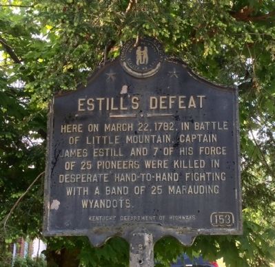
Estill's Defeat
Here on March 22, 1782, in Battle of Little Mountain, Captain James Estill and 7 of his force of 25 pioneers were killed in desperate hand-to-hand fighting with a band of 25 marauding Wyandots.
Erected by the Kentucky Department of Highways. (Marker Number 153.)
Topics. This historical marker is listed in these topic lists: Colonial Era • Native Americans • Wars, US Indian. A significant historical date for this entry is March 22, 1782.
Location. 38° 3.922′ N, 83° 56.702′ W. Marker is in Mount Sterling, Kentucky, in Montgomery County. Marker is at the intersection of Hinkston Pike (Kentucky Route 1991) and Maysville Pike (U.S. 460), on the right when traveling east on Hinkston Pike. Touch for map. Marker is at or near this postal address: 2 Hinkston Pike, Mount Sterling KY 40353, United States of America. Touch for directions.
Other nearby markers. At least 8 other markers are within walking distance of this marker. Montgomery County Veterans Memorial (approx. 0.6 miles away); Battle of Mt. Sterling (approx. 0.6 miles away); Montgomery County World War II Memorial (approx. 0.6 miles away); Montgomery County Kentucky Vietnam Casualties (approx. 0.6 miles away); Montgomery County Kentucky World War I Memorial (approx. 0.6 miles away); Montgomery County Korean War Memorial (approx. 0.6 miles away); Courthouse Burned (approx. 0.6 miles away); Montgomery County. 1797 (approx. 0.6 miles away). Touch for a list and map of all markers in Mount Sterling.
Also see . . .
1. Battle of Little Mountain. Wikipedia entry (Submitted on May 20, 2015, by Mark Hilton of Montgomery, Alabama.)
2. Firefight At Little Mountain — Estill’s Defeat. Frontier Partisan's website entry (Submitted on April 15, 2022, by Larry Gertner of New York, New York.)
Credits. This page was last revised on April 15, 2022. It was originally submitted on May 20, 2015, by Mark Hilton of Montgomery, Alabama. This page has been viewed 1,180 times since then and 93 times this year. Photos: 1, 2, 3, 4. submitted on May 20, 2015, by Mark Hilton of Montgomery, Alabama.


