On St. Martin Street at Gray Street, on the right when traveling north on St. Martin Street.
This parish was one of the sites proposed by Bishop Jules B. Jeanmard, Bishop of the Diocese of Lafayette, to afford a place of work for African-American priests ordained in the United States in 1934. Rev. Maurice Rousseve, SVD and his . . . — — Map (db m125811) HM
On Federal Avenue south of Adams Street, on the right when traveling south.
Erected in 1865, after the signing of the Emancipation Proclamation. Freed slaves used the land given by Mr. Olympus Young. Mr. Lawrence, former slave owner, gave the worship bell. Its history is rich with over thirteen ministers sharing . . . — — Map (db m98405) HM
On Group Camp Road (State Highway 1089) 1 mile south of U.S. 190.
Beneath this alley of oaks were 20 double cabins that housed enslaved families from 1829 to 1862. They were the workforce for Marigny's Fontainebleau Plantation and included skilled steam engineers who managed the power source for the sugar presses . . . — — Map (db m139148) HM
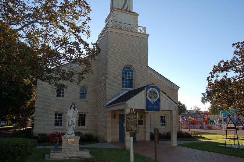
On Roussell Street east of Tunnel Boulevard, on the left when traveling east.
The Fifth Districts High School was built in 1893. It is the work of Mr. John Reason under the leadership of Dr. Henry C. Cotton of Bella Alliance, LA. This location was once called Newtown present day Houma, LA. here in the Parish of Terrebonne. . . . — — Map (db m155158) HM
On Saint Charles Street (State Highway 664) near West Tunnel Boulavard (Highway 3040), on the right when traveling south.
Southdown High School served as an African-American high school from 1953 to 1969. The school served as a source of pride and as an institution of learning for all African-American students. Many well-known, local educators and community leaders . . . — — Map (db m137495) HM
On South Louisiana Street, 0.1 miles south of East Lafayette Street, on the left when traveling south.
Believed to be the first school in Vermilion Parish to educate freed southern slaves. Pastored by Rev. James A. Herod, the Father of African American education in Vermilion Parish. — — Map (db m104916) HM
On East Robert "Bob" Hicks Street at Marx Avenue, on the right on East Robert "Bob" Hicks Street.
Side 1 Fueled by discriminatory practices & violent intimidation that permeated his community, threatened his family & friends, Mr. Hicks developed an unquenchable thirst for justice & equality. He "sparked the spirits" of people & . . . — — Map (db m103257) HM
On Church Street east of Poplas Street, on the left when traveling east.
The Greater Ebenezer Baptist Church has been utilized in support of community and civil rights activities prior and since the historic 1960s Civil Rights Movement. The only church in the Bogalusa community that permitted assembly of grassroots . . . — — Map (db m144422) HM
On State Highway 21 at Main Street, on the right when traveling south on State Highway 21.
O'Neal Moore (1931-1965) and his partner, David “Creed” Rogers were the first black deputies of the Washington Parish Sheriff's Office. June 2, 1965, the deputies were ambushed by alleged members of the Ku Klux Klan in a drive-by shooting . . . — — Map (db m115681) HM
On First Street, 0.5 miles south of State Highway 1, on the left when traveling south.
St. Mary's A.M.E. Church was founded on
September 16, 1888 and erected in 1889.
August Levert, plantation owner, donated
a tract of land to
Albert Henderson to build a
church under the doctrines of the
African Methodist Episcopal . . . — — Map (db m121111) HM
Established 1865
Oldest African-American Baptist Church in West Baton Rouge Parish. Luke Billups, Sr. a native of Virginia, built the church and served as first pastor. The community “Lukeville” grew from property he purchased in 1867. . . . — — Map (db m86902) HM
On State Highway 1 near St. Francis Street, on the left when traveling south.
July 21, 1873 – June 27, 1961 Charles Philip Adams, Brusly native and Tuskegee Institute graduate, followed Booker T. Washington’s advice to travel to North Louisiana to develop a school. On November 1, 1901, Adams founded and opened the . . . — — Map (db m86590) HM
On Vaughan Drive south of East Francis Street when traveling south.
Herbert O. Dickerson, son of Osborne and Mary Dickerson, was born at their home on Paul Lane near Brusly, Louisiana, and raised in that area throughout his life except for his time of military service. After being drafted into the service during . . . — — Map (db m109921) HM
On Vaughn Drrive north of Lukeville Lane (Louisiana Highway 989-1), on the right when traveling north.
Established by Luke Billups in 1887 at Antioch Missionary Baptist Church, Lukeville School has provided elementary education since its founding. In addition to serving the Lukeville community, it also served black students from nearby areas. . . . — — Map (db m86881) HM
On South River Road (State Road 988) south of Red Hat Drive, on the right when traveling south.
This institution of worship can trace its roots to the 1890s,
but it was formally chartered in 1905. The congregation was
established as Israelite Baptist Church of Brusly Landing.
The original church was a rectangular gable ended . . . — — Map (db m121116) HM
On Gwin Street at LeJeune Street, on the left when traveling east on Gwin Street.
Oral tradition recounts a visit by an African American gospel
preacher in 1804. He preached the Baptist Christian Doctrine
for the first time in West Baton Rouge near the foot of the
levee where present day Gwin St. would have met the . . . — — Map (db m121129) HM
On Ronald Reagan Highway (U.S. 190) at South Mulatto Bend Road, on the right when traveling east on Ronald Reagan Highway.
Blues artist "Slim Harpo" was born James Moore in Lobdell, LA in February 1924. He worked as a longshoreman and construction worker during the late 1930's and early 40's. He began performing in Baton Rouge bars as "Harmonica Slim". Harpo began his . . . — — Map (db m85007) HM
On River Road (State Highway 986) at Faye Street (State Highway 987-2), on the right when traveling south on River Road.
(Side A)
In 1874 Alexander Banes, a former slave, purchased property which he sold to Sunrise Realty Co. in 1905. About 1906 the Missouri-Pacific Railroad began using a train-ferry to cross the Mississippi River, causing a great spurt in . . . — — Map (db m92001) HM
On Ferdinand Street (State Road 1263) near Cr. 420, on the right when traveling east.
In the aftermath of the Civil War, benevolent societies filled an urgent need for medical care and burials of freed slaves
that had once been filled by the masters of the plantations. As the years passed these societies served as a way to
provide . . . — — Map (db m238150) HM
219 entries matched your criteria. Entries 201 through 219 are listed above. ⊲ Previous 100