By the 1890s the Rock Creek Railway Company's new electric streetcars made it easy to commute across town. The "country" settlements of this area became "suburban." One streetcar line followed 18th to Calvert Street, passed here, and then . . . — — Map (db m130701) HM
Three dramatic religious structures dominate this corner. They are among some 40 religious institutions lining 16th Street between the White House and the Maryland state line.
Many serve as unofficial “embassies” representing the . . . — — Map (db m152206) HM
Across the street you can see the Marie H. Reed Community Learning Center. It opened in 1977 on the former sites of Morgan Community School and Happy Hollow Playground.
Both the Adams and Morgan elementary schools became "community schools" . . . — — Map (db m130703) HM
You are standing in front of the Embassy of the Republic of Lithuania.
The Spanish Baroque style mansion is all that remains of what was once a duplex, or double, embassy building designed by George Oakley Totten for Mary Foote Henderson's . . . — — Map (db m82711) HM
Embassy of the Republic of Poland
A Beaux-Arts Beauty
You are now standing in front of the longest-serving embassy building among Washington DC's more than 180 diplomatic missions: the Embassy of the Republic of Poland. . . . — — Map (db m82636) HM
Banker Archibald McLachlen and Smithsonian Institution naturalist George Brown Goode developed Lanier Heights in the early 1890s. Goode laid out streets and encouraged Smithsonian colleagues to purchase lots. McLachlan built the elegant . . . — — Map (db m130704) HM
During the Civil War (1861-1865), the Union Army Carver Hospital and barracks occupied Meridian Hill. The facilities attracted African American freedom seekers looking for protection and employment. By war’s end, a Black community had put down . . . — — Map (db m130705) HM
Since 1924 this mansion has housed representatives of the Republic of Lithuania, even during the 50 years when the country was occupied by the Soviet Union.
In the late 1700s, the Russian Empire annexed Lithuania's territory, ending the . . . — — Map (db m82751) HM
Long before Europeans arrived, Meridian Hill was a sacred place for Native Americans. As recently as 1992, a delegation of Native Americans walked across the continent to this park to mourn the 500th anniversary of Columbus’s arrival. They were . . . — — Map (db m130706) HM
As you look up the hill, you can see Peter C. L’Enfant’s 1791 plan for Washington ended up here in front of you at Boundary Avenue, now Florida Avenue. Back then, when people walked or rode in horse-drawn vehicles, it was hard to climb this . . . — — Map (db m130707) HM
This hill, with its sweeping views of Washington and the Potomac, has tantalized visionaries since the 1800s. But few of their plans have been built. In 1873 businessman and city commissioner Thomas P. Morgan (whose name survives as part of . . . — — Map (db m93415) HM
Furs by Gartenhaus and truffles by Avignon Freres. Hand-crafted ice cream from Budd's. Beginning in the 1910s, such neighborhood favorites occupied the commercial buildings to your right developed by Sanner and Barr. These fashionable shops . . . — — Map (db m130708) HM
The lively scene around you began with an arts movement in the 1950s. Musicians, dancers, and artists found centrally located 18th Street attractive as declining rents made it affordable.
Early on, jazz guitarist Charlie Byrd brought fame . . . — — Map (db m152207) HM
The large building to your left is Adams School (1930), built for white students when the DC Public Schools were segregated. An Americanization School taught immigrant adults and children the English language and American culture here from . . . — — Map (db m184988) HM
This is the heart of Washington’s Latino community. Once centered here and in nearby Mount Pleasant and Columbia Heights, the community now extends throughout the region.
As early as the 1910s, the Mexican, Ecuadoran, Cuban, and Spanish . . . — — Map (db m130709) HM
In 1947, the building on your left opened as the National Arena, a public roller rink and bowling alley. It also hosted professional wrestling, roller derbies, and rock concerts. In 1986 it became the Citadel Motion Picture Center, where . . . — — Map (db m130710) HM
Before there was "Adams Morgan," this crossroads lent the neighborhood its name: "18th and Columbia." Here you could catch a streetcar to just about anywhere and buy nearly anything.
But back in 1922, 18th and Columbia witnessed a tragedy. . . . — — Map (db m130711) HM
The charming Victorian rowhouses you see along 18th Street are an Adams Morgan signature. But they were nearly lost in the 1960s in the name of progress.
During World War II, thousands flooded Washington to work for the government, . . . — — Map (db m130712) HM
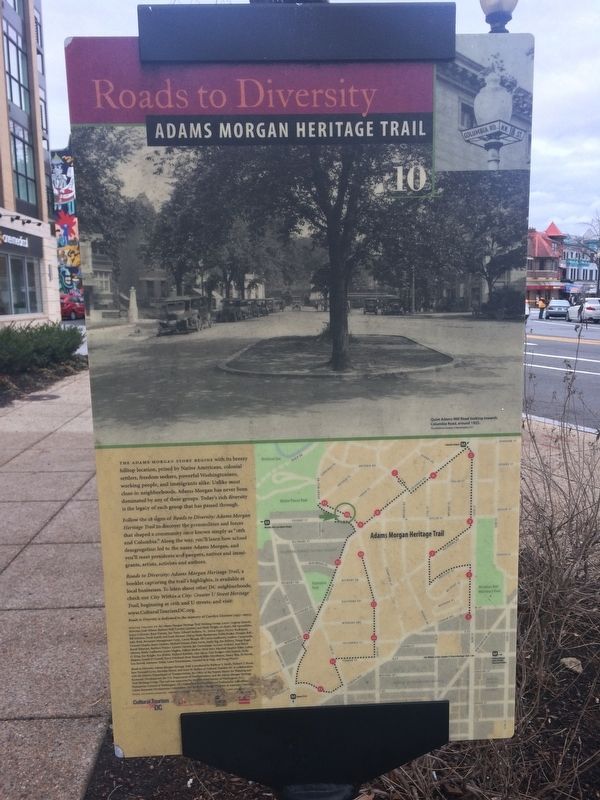
The Rock Creek Valley, once home to Native Americans, had attracted European settlers by 1703. Before he became president in 1825, John Quincy Adams purchased Adams Mills on Rock Creek from his cousin. The mills, just down the hill, processed . . . — — Map (db m130713) HM
dubbed "best addresses" by historian James Goode, the grand apartments of the Kalorama Triangle are among the city's earliest. The Mendota (1901) located at 2220 20th, is the city's oldest intact luxury apartment house. The Wyoming (1905_1911), . . . — — Map (db m130714) HM
You are standing in the Kalorama Triangle Historic District, listed on the National Register of Historic Places since 1987. Most of its elaborate houses were built between 1888 and 1930 in what was then the "Washington Heights" subdivision. . . . — — Map (db m130715) HM