On Memorial Drive near State Route 69 (New York State Route 69), on the right when traveling north.
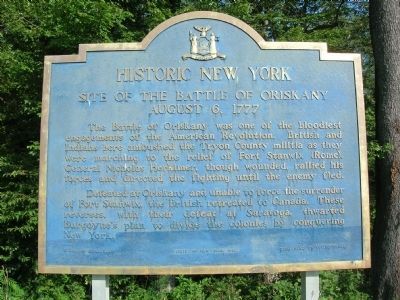
Historic New York
Site of The Battle of Oriskany
August 6, 1777
The Battle of Oriskany was one of the bloodiest engagements of the American Revolution. British and Indians here ambushed the Tryon County militia as they were marching to . . . — — Map (db m22747) HM
On Rome Oriskany Road (New York State Route 69) 0.4 miles east of Monument Road, on the left when traveling east.
[Tablet on South Side of Monument]
Here the Battle of Oriskany was fought
On the sixth day of August, A.D. 1777
Here British invasion was checked and thwarted
Here General Nicholas Herkimer, intrepid leader
Of the American forces . . . — — Map (db m32119) HM
Both sides regrouped during a driving rain. Herkimers's troops concentrated here, forming an irregular circle. The attackers were on all sides. — — Map (db m22893) HM
Near Rome Oriskany Road (New York State Route 69) 0.4 miles east of Monument Road, on the left when traveling east.
In the Valley homes was great mourning. For such a small population, the losses were almost overwhelming. In some families the male members were wiped out. It was many a long, weary year before the sorrow and suffering caused by the sacrifices at . . . — — Map (db m32034) HM
On Rome Oriskany Road (New York State Route 69) 0.4 miles east of Monument Road, on the left when traveling west. Reported missing.
A three-pronged attack, known as the Campaign of 1777, was launched by the British under the direction of Maj. Gen. John Burgoyne. The strategy was to split New England from the other colonies by gaining control of New York State.
During his . . . — — Map (db m32036) HM
On Rome Oriskany Road (New York State Route 69) 0.4 miles east of Monument Road, on the left when traveling east. Reported missing.
Down this valley, the Indians, realizing the battle had been turned in favor of the Patriots, began to yell their cry of retreat: "Oonah, oonah!" Vanishing into the valley as quickly as they had appeared, they would carry terror to the settlements . . . — — Map (db m32047) HM
On Rome Oriskany Road (New York State Route 69) 0.4 miles east of Monument Road, on the left when traveling east. Reported missing.
Gen. Nicholas Herkimer, wounded early in the battle, was carried to a safer spot beneath a beech tree now marked by a stone monument. Although urged by his militiamen to retire from danger, he replied: "I will face the enemy!"
Directing the . . . — — Map (db m32056) HM
On Rome Oriskany Road (New York State Route 69) 0.4 miles east of Monument Road, on the left when traveling east.
40 mile route taken by Gen. Herkimer Aug. 3-6, 1777 for the relief of Fort Stanwix. The Battle of Oriskany Aug. 6, between Herkimer's men and St. Leger with his Indians was the turning point of the Revolution.
Near this spot
Stood the . . . — — Map (db m32062) HM
On Rome Oriskany Road (New York State Route 69) 0.4 miles east of Monument Road, on the left when traveling east.
Joseph Brant, familiar with the terrain, probably selected the place of ambush ~ where a small stream crossed the military road. The military road of 1777 was about ten rods north of the present highway. — — Map (db m32040) HM
On Rome Oriskany Road (New York State Route 69) 0.4 miles east of Monument Road, on the left when traveling east.
The militia column, on its way to the relief of Fort Stanwix, marched into this ravine, August 6, 1777, and were ambushed by Loyalists and British. The attackers came out of hiding in woods on the west, the south and the north. — — Map (db m32045) HM
Parched and exhausted from heat and humidity on their march to Fort Stanwix, some of General Herkimer’s men broke ranks and ran to this creek for water. Although Sir John Johnson had told his Indian allies not to attack until all of Herkimer’s men . . . — — Map (db m16106) HM
The military road
On August 6, 1777, the Tryon County militia marched down a wilderness road that entered this ravine. A “corduroy” road, made of logs, it was the only means by which General Herkimer and his men could reach Fort . . . — — Map (db m16109) HM
On Rome Oriskany Road (New York State Route 69) 0.4 miles Monument Road, on the left when traveling east. Reported missing.
A three-pronged attack, known as the Campaign of 1777, was launched by the British under the direction of Maj. Gen. John Burgoyne. The strategy was to split New England from the other colonies by gaining control of New York State.
During his . . . — — Map (db m32157) HM
Near Rome Oriskany Road (New York State Route 69) 0.4 miles east of Monument Road, on the left when traveling east.
(Center/Main Marker)
To The Unknown Patriotic Soldiers of Tryon County
Who Under The Leadership Of
Colonel Ebenezer Cox • Colonel Jacob Klock
Colonel Peter Bellinger • Colonel Frederick Visscher
Followed
— Herkimer — . . . — — Map (db m241579) HM WM