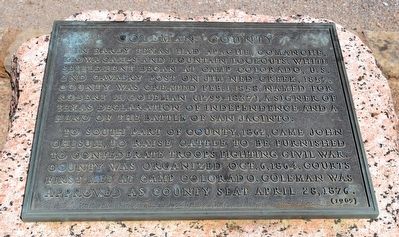
Near U.S. 84 west of County Road 106, on the left when traveling east.
In early Texas had Apache, Comanche, Kiowa camps and mountain lookouts. White settlement began at Camp Colorado, U.S. 2nd Cavalry post on Jim Ned Creek, 1857. County was created Feb. 1, 1858. Named for Robert M. Coleman (1799-1837), a signer of . . . — — Map (db m94526) HM
On County Road 441 0.1 miles west of County Road 490, on the right when traveling west.
Settlement of this area began in the 1850s with the establishment of Camp Colorado, a United States Cavalry outpost. At the outbreak of the Civil War the camp was occupied by Texas state troops and Texas Ranger units. The existence of the camp . . . — — Map (db m78265) HM
On 2080 North Amerind Road, on the right when traveling east.
In 1895, seventeen-year-old William Walter Adams left Coleman County, Texas, to visit his older brother, Dave A. Adams, who was one of the first of the Adams family to settle in the Little Dragoon Mountains of Cochise County. "Will," soon decided . . . — — Map (db m216038) HM
Near U.S. 84/283 0.1 miles Roosevelt Street, on the right when traveling north.
(Front Side)
South Carolinian. Came to Texas 1853 ▲ Surveyor of lands in this region, including the site of Camp Colorado ▲ Texas Ranger ▲ Prominent secessionist. Member Texas state troops at start of Civil War ▲ . . . — — Map (db m85761) HM
On Farm to Market Road 1235 south of County Road 302, on the right when traveling south.
On New Year’s Day, 1871, Indian raiders who had stolen horses in Coleman County were pursued and overtaken here by 18 Texas Rangers and cowboys. Leaders of the group were Captain James M. Swisher and rancher Sam Gholson.
The Indians took . . . — — Map (db m77733) HM
Near W. College Avenue at S. Neches Street, on the right when traveling west.
A native of Georgia, J.T. Blair (1876-1949) migrated to this area in 1897. He married Carrie Agnes Love, of a pioneer Coleman County family. They had five children. Blair served as foreman of the Overall Ranch, in addition to managing his own ranch . . . — — Map (db m94452) HM
On Farm to Market Road 503 0.2 miles south of County Road 422, on the right when traveling south.
In 1936, the Valera, Bowen, White Chapel and New Central communities established a common high school. The new centralized campus – the second rural high school in Coleman County – was named to commemorate Texas’ centennial of . . . — — Map (db m94383) HM
Near Farm to Market Road 2134 0.2 miles west of Recreational Road 9.
This monument is dedicated to the memory of those persons that were buried in the Trap Crossing Cemetery (also known as Boot Hill Cemetery, Padgitt Ranch Cemetery, and Trigger Cemetery); the Coffey Cemetery; and the Gann Family Cemetery. The remains . . . — — Map (db m94417) HM
Thin black lines indicate changes in relevance. Between each pair of lines entries are ordered geographically but all have the same relevance.
* Inflectional forms of words are their plurals, singulars, and possessives as well as gramatical tenses and similar variations.