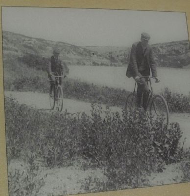
On Wilcox Street, on the right when traveling south.
Even before people began driving automobiles in Colorado, they clamored for good roads. In the late 1880s men, women, and children of all backgrounds jumped on breezy bicycles known as “velocipedes” or “Wheels” but cursed the roads-rutted, unmarked, . . . — — Map (db m46118) HM
On Wilcox Street at 4th Street NE, on the right when traveling south on Wilcox Street. Reported missing.
The reasons for Douglas County’s popularity in the late twentieth century-rolling landscapes, pastoral scenery, and the proximity to a big city-also attracted late-nineteenth century settlers. In November 1861, territorial legislators created . . . — — Map (db m46117) HM
On Wilcox Street at 4th Street NE & Wilcox Street, on the right when traveling west on Wilcox Street. Reported missing.
The founders of Castle Rock platted their town beneath a prominent rock outcrop of the same name in 1874, and proudly advertised it as a year-round resort, knowing the value of beautiful scenery to attract settlers and tourists. But even greater . . . — — Map (db m49803) HM
On State Highway 83 at Lost Lake Drive, on the right when traveling south on State Highway 83.
Panel 1
Russellville
For a few exciting months, Russellville felt like Colorado's gold-rush capital. The town rose five miles southeast of here in late 1858, after William Green Russell discovered a few gleaming . . . — — Map (db m97969) HM
Near East Valley Hi Drive at South Parker Road (State Highway 83).
In 1846 the unsettled area that is now Parker, Colorado, consisted of wild open plains, inhabited only by local Indian tribes and passing trappers and traders. The Crosby-Brown Company, otherwise known as the Mississippi Saints, and detachments of . . . — — Map (db m97420) HM
On Wilcox Street close to 3rd Street, on the right when traveling south.
A geologic phenomenon known as a “glowing avalanche” formed Castle Rock and the other buttes of Douglas County 36.7 million years ago. A volcanic eruption near Mount Princeton, about 95 miles southwest of here, spewed a frothy, gleaming cloud of . . . — — Map (db m46142) HM
On State Highway 83 0.1 miles south of State Highway 86, on the right when traveling south.
This tablet is the
property of the State of Colorado
——
Franktown
Named for J. Frank Gardiner, a
pioneer who settled here in 1859.
First known as "California Ranch,"
it was a way . . . — — Map (db m96174) HM
On Dodge Street west of Farnam Street, on the right when traveling west.
The story of the Dodge Street Pedestrian Overpass began with parents' concern about the safety of their children walking to school. Responding to post-World War II growth in student population and requests from parents, the City of Omaha began . . . — — Map (db m265937) HM
Thin black lines indicate changes in relevance. Between each pair of lines entries are ordered geographically but all have the same relevance.
* Inflectional forms of words are their plurals, singulars, and possessives as well as gramatical tenses and similar variations.