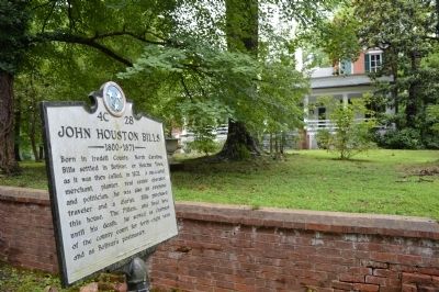
On S Washington Street, on the left when traveling north.
Born in Iredell County, North Carolina, Bills settled in Bolivar, or Hatchie Town, as it was then called, in 1821. A successful merchant, planter, real estate operator and politician, he was also an extensive traveler and a diarist. Bills purchased . . . — — Map (db m84785) HM
On South Center Street (North Carolina Route 115) south of Court Street, on the right when traveling south. Reported permanently removed.
(Preface):
On March 24, 1865, Union Gen. George Stoneman led 6,000 cavalrymen from Tennessee into southwestern Virginia and western North Carolina to disrupt the Confederate supply line by destroying sections of the Virginia and Tennessee . . . — — Map (db m262946) HM
On South Center Street (North Carolina Route 115) south of Court Street, on the left when traveling north.
After destroying the Confederate supply depot and prison at Salisbury, Union Gen.
George Stoneman led his raiders west toward Tennessee, arriving in Statesville
on the night of April 13, 1865. Here his men burned supplies, the railroad depot,
and . . . — — Map (db m262947) HM
On Langtree Road (State Road 1102) at Mount Mourae Road, on the right when traveling west on Langtree Road.
where skirmish between British
and American soldiers occurred
February 1781.
Erected by
Mary Slocumb Chapter D.A.R.
1914.
Rededicated 2014 — — Map (db m237287) HM
On Windsor Road at Buck Shoals Road, on the right on Windsor Road.
(Preface):
On March 24, 1865, Union Gen. George Stoneman led 6,000 cavalrymen from Tennessee into southwestern Virginia and western North Carolina to disrupt the Confederate supply line by destroying sections of the Virginia and Tennessee . . . — — Map (db m55343) HM
Near McKendree Road at Fulton Farms Lane, on the right when traveling south.
The Library of Congress, Washington, D.C. records that His Excellency Governor Thomas Mayhew, born 1593 Tisbury, England, who was the English Crown Governor of the Elizabeth Island chain including Martha's Vineyard and Nantucket islands off the . . . — — Map (db m237235) HM
On State Highway 73 at Eastlake Lane, on the right when traveling west on State Highway 73.
In 1747 Adam Sherrill and his 8 sons migrated from Pennsylvania and settled west of the Catawba River. By July, 1749, John Beatty had also crossed the Catawba. Sherrill’s Ford (site underwater) and Beatty’s Ford (underwater) were named for them. . . . — — Map (db m156502) HM
Near Gilead Road 0.1 miles west of Old Store Road, on the right when traveling west.
Hugh Torance House and Store, originally a simple log cabin dating to 1779, is the oldest standing store in North Carolina, and one of the few remaining 18th-century structures in Mecklenburg County.
Who was Hugh Torence
In 1763, Hugh . . . — — Map (db m307354) HM
On Savannah River Scenic Byway (State Highway 28) at Barksdale Ferry Road (County Route S-33-61), on the left when traveling west on Savannah River Scenic Byway.
Badwell
Three miles west is the site of "Badwell," home of James Louis Petigru (1789-1863), leader of opposition to secession in South Carolina, outstanding Charleston lawyer, and S.C. Attorney General. He studied at Willington Academy under . . . — — Map (db m11456) HM
On State Highway 81 at Morrah Bridge Road (County Route 39), on the left when traveling north on State Highway 81.
Cherry Hill
Three miles southwest is "Cherry Hill," site of the home of George McDuffie (1790-1851), orator of nullification, member of the U.S. House of Representatives and the U.S. Senate, Major General of the State Militia, and Governor of . . . — — Map (db m11461) HM
On SC Highway 81, on the right when traveling north.
The community of Willington is significant as a reminder of the role of the railroad in community development in rural South Carolina at the close of the nineteenth century and beginning of the twentieth century. During this period Willington was . . . — — Map (db m11458) HM
Two miles southwest is the site of the famous classical academy which was established in 1804 by Rev. Moses Waddel, D.D., one of the greatest educators of his day. Here from 1804-1819 he taught hundreds of ambitious boys of great potentiality who . . . — — Map (db m9373) HM
On September 25, 1830, Mary Ann (Hudspeth) Webb (ca 1772-1842) used the proceeds from the sale of her land holdings in North Carolina to buy 200 acres of land in Overton County, located on the east side of the Obed River, about 1 ½ miles . . . — — Map (db m112216) HM
On South Center Street (North Carolina Route 115) at Court Street, on the right when traveling south on South Center Street.
National Register
of Historic Places
Listed by the United States Department of the Interior, 1980
Statesville Commercial District
Historic Downtown Statesville
— — Map (db m264857) HM
On South Center Street (U.S. 21) at West Sharpe Street, on the right when traveling south on South Center Street.
Dedicated to the memory of Col. Silas A. Sharpe,
a prominent industrialist and political leader in
Statesville throughout the second half of the 19th
century. He was sworn as the first Mayor of the
City of Statesville on March 25, 1867. The . . . — — Map (db m237105) HM
On East Sharpe Street at South Tradd Street, on the right when traveling east on East Sharpe Street.
[Top plaque]
This property has been
placed on the
National Register
of Historic Places
by the United States
Department of the Interior
[Bottom plaque]
St. Philip the Apostle
Catholic Church
1898-1956 . . . — — Map (db m237112) HM
Thin black lines indicate changes in relevance. Between each pair of lines entries are ordered geographically but all have the same relevance.
* Inflectional forms of words are their plurals, singulars, and possessives as well as gramatical tenses and similar variations.