118 entries match your criteria. Entries 101 through 118 are listed.⊲ Previous 100
New Hampshire Historical Highway Markers
Marker series sponsored by the NH Division of Historical Resources and NH Department of Transportation (green background, white lettering, with the multi-colored state seal on top).
On Woodstock Street west of Ocean Drive, on the left when traveling west.
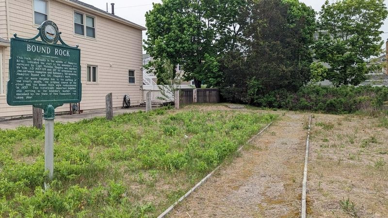
This rock, originally in the middle of Hampton River, indicated the start of the boundary line surveyed by Capt. Nicholas Shapley and marked by him AD 1657-HB and SH to determine the line between Hampton and Salisbury. HB meaning. Hampton Bound and . . . — — Map (db m223644) HM
On Franklin Pierce Highway (New Hampshire Route 9) 0.1 miles east of Oak Hill Road, on the right when traveling east.
The reinterred graves of two members of the Balch Household are in Pine Grove Cemetery. Rev. Benjamin Balch (1743-1815) was the first chaplain of the Continental Navy and earned the title of “Fighting Parson,” then served as the pastor of the local . . . — — Map (db m235105) HM
Noted preacher, educator, naturalist and historian. Born Boston, Mass. Harvard College 1762. School teacher at Portsmouth and Greenland. Pastor of First Congregational Church at nearby Dover, 1766-1786. Published first History of New Hampshire. . . . — — Map (db m224729) HM
On Boston Harbor Rd. (U.S. 4 at milepost 101.6), on the right when traveling east.
A Revolutionary patriot, soldier, and adopted son of Durham, N.H., Alexander Scammell served with distinction through six years of the war from Bunker Hill to Yorktown, where he was wounded, captured, and died six days later, Oct. 6, 1781. Born in . . . — — Map (db m74582) HM WM
Packer's Falls
These scenic falls, 1.6 miles west of here on the
Lamprey River, once provided waterpower and industry for the early settlers. A deed dated April II, 1694, shows that Capt. Packer, Jonathan Woodman, James Davis, Joseph Meder, and . . . — — Map (db m224730) HM
On Main Street (New Hampshire Route 12) at Olcott Lane on Main Street.
Carlton attended Charlestown schools, starring in basketball, soccer and baseball at Charlestown High School. He played professional baseball for the Boston Red Sox and the Chicago White Sox from 1969 to 1993, where he set several records including . . . — — Map (db m74583) HM
On Main Street (New Hampshire Route 12) north of Olcott Lane, on the left when traveling north.
In 1744 the settlers at No. 4 (now Charlestown) built a great log fort enclosing many of the town's dwelling. The fort, northernmost in the Connecticut Valley, was besieged in 1747 by a large force of French and Indians, who were beaten off by the . . . — — Map (db m74584) HM WM
On Main Street (SR 12) at Elm Street on Main Street (SR 12).
To impede a British invasion from Canada into eastern New York, the New Hampshire legislature on July 19, 1777, commissioned John Stark of Derryfield to recruit and lead a force of 1500 New Hampshire militiamen. At Charlestown’s Fort No. 4, forces . . . — — Map (db m74585) HM
On New Hampshire Route 12 at Plains Road on State Route 12.
Southerly on Old Church Road is located the first Roman Catholic edifice in New Hampshire. It was erected in 1823 under the direction of the Reverend Virgil Horace Barber, S.J. The building serves St. Mary's parish and contained the first Roman . . . — — Map (db m109414) HM
On Maple Avenue, 0.1 miles west of Buenavista Road, on the right when traveling west.
On June 11, 1995, President William Jefferson Clinton and Speaker of the U.S. House of Representatives Newt Gingrich met at the invitation of the Congress of Claremont Senior Citizens, Inc. to debate issues affecting senior citizens. During the . . . — — Map (db m109337) HM
On Jarvis Hill Road (New Hampshire Route 12A) at Half Mile Road, on the right when traveling south on Jarvis Hill Road.
Located easterly on Old Church Road, this wood-frame structure, built 1771–1773, is the oldest standing Episcopal church in the State, serving the second oldest parish. The parish began in 1768 as a mission of the Society for the Propagation . . . — — Map (db m109370) HM
On Chase Road (SR 12A) at Bridge Street on Chase Road (SR 12A).
Built in 1866 at a cost of $9,000, this is the longest wooden bridge in the United States and the longest two-span covered bridge in the world. The fourth bridge at this site, the 460-foot structure was built by Bela J. Fletcher (1811-1877) of . . . — — Map (db m74586) HM
On Chase Road (New Hampshire Route 12A) 0.1 miles south of McSwain Road, on the left when traveling south.
In this house was born Salmon P. Chase, U.S. Senator from Ohio (1849-55), Governor of Ohio (1855-59), a founder of the Republican Party and leader in the anti-slavery movement. After serving as Secretary of the Treasury in Lincoln’s Cabinet, he was . . . — — Map (db m74587) HM
On Wilson Road (New Hampshire Route 12A) 0.1 miles north of St. Gaudens Road, on the right when traveling north.
The Cornish Colony (1885–1935) was a group of artists, sculptors, writers, journalists, poets, and musicians who joined the sculptor Augustus Saint-Gaudens in Cornish and found the area a delightful place to live and work. Some prominent . . . — — Map (db m109373) HM
On Wilson Road (New Hampshire Route 12A) 0.3 miles south of Ferry Crossing Hill Road, on the right when traveling south.
American author of best-selling novels, such as "Coniston", written between 1898-1941 and partly based upon actual experience in New Hampshire politics. His nearby residence, "Harlakenden House", was built in 1898 and burned in 1923. It also served . . . — — Map (db m109401) HM
On Lempster Street at Pitkin Road, on the left when traveling south on Lempster Street.
On nearby Allen Road on December 4, 1939, the New Hampshire Electric Cooperative set its first utility pole, an important event in bringing electric service to the farms, mills, and homes of the New Hampshire countryside. A group of citizens . . . — — Map (db m230344) HM
On New Hampshire Route 120 at Main Street on State Route 120.
This school, known first as Union Academy, was chartered June 16, 1813 "to train young men for leadership in the ministry." The original building, located about 1,000 feet west of here and dedicated to January 9, 1815, was destroyed by fire in . . . — — Map (db m109402) HM
On South Main Street (New Hampshire Route 31), on the right when traveling north.
In April 1842, a group of citizens in this town banded together to form "the first Christian Society." In the Adventist movement of 1842-43, they espoused the Advent hope. In January 1842, these Washington Sabbathkeepers, after meeting for many . . . — — Map (db m73224) HM
118 entries matched your criteria. Entries 101 through 118 are listed above. ⊲ Previous 100