4 entries match your criteria.
Related Historical Markers
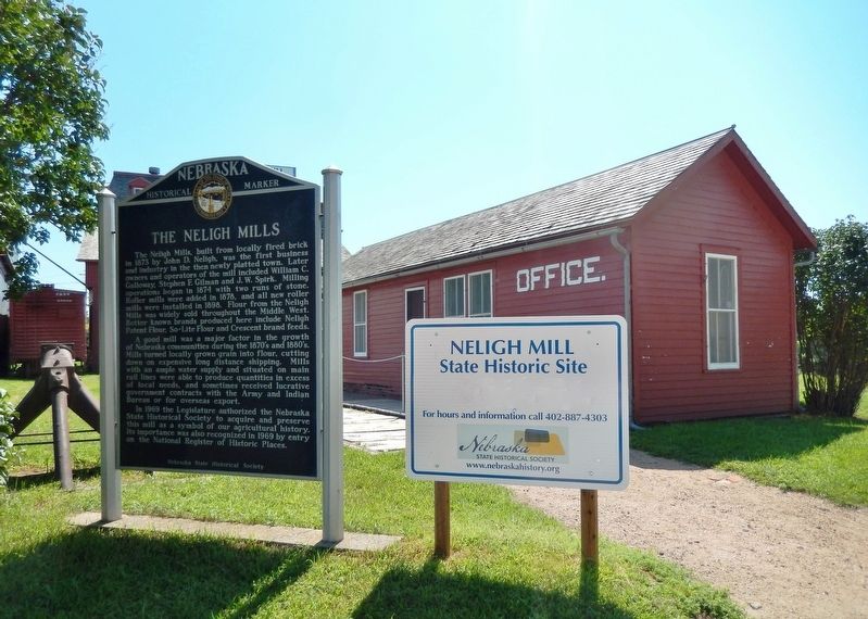
Neligh Mill State Historic Site
By Cosmos Mariner, August 17, 2014
The Neligh Mills Marker
SHOWN IN SOURCE-SPECIFIED ORDER
| On East 2nd Street at N Street, on the left when traveling west on East 2nd Street. |
| | The Neligh Mills, built from locally fired brick in 1873 by John D. Neligh, was the first business and industry in the then newly platted town. Later owners and operators of the mill included William C. Galloway, Stephen F. Gilman and J. W. Spirk. . . . — — Map (db m159000) HM |
| On N Street south of East 2nd Street, on the left when traveling south. |
| | Water = Power The Elkhorn River was an unlimited source of water power for flour mills and other manufacturing enterprises. But entrepreneurs found the meandering river difficult to harness. Too much water was as bad as too little. The key to . . . — — Map (db m158999) HM |
| On N Street south of East 2nd Street, on the left when traveling south. |
| | A Route and a Power Source: The Elkhorn Valley The Elkhorn Valley was a natural travel corridor into north-central and western Nebraska. Water, wood, and grass provided people and animals the critical resources to move overland wagons. Travel . . . — — Map (db m159076) HM |
| On N Street south of East 2nd Street, on the left when traveling south. |
| | With the establishment of the Neligh Mill and the platting of the town of Neligh, a crossing of the Elkhorn River here aided farm-to-market commerce. This bridge, built in 1910, replaced an earlier span at this location. It is a pin-connected Pratt . . . — — Map (db m158998) HM |
Jun. 17, 2024