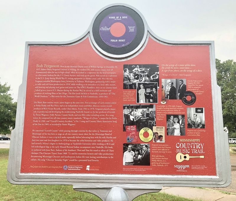
On Industrial Road 0.1 miles east of High School Circle, on the right when traveling east.
Long-time Neshoba County resident Bob Ferguson (1927-2001) was a key shaper of the “Nashville Sound” of the 1960s and ‘70s, as the producer of hundreds of major recordings and writer of such classic country songs as “Wings of a Dove” and “Carroll . . . — — Map (db m140732) HM
On Rebel Drive at Dormitory Row North, on the right when traveling east on Rebel Drive.
In 1920, this building was dedicated in honor of James Zachariah George (1826-1897). Born in Georgia, George moved with his family to Mississippi in 1834, settling two years later in Carroll County.
At the outbreak of war between the United . . . — — Map (db m219881) HM
On Jackson Street east of Lexington Street (State Route 17), on the right when traveling east.
Blending blues and old-time dance tunes,
fiddler William T. Narmour (1889-1961) and
guitarist Shellie W. Smith (1895-1968) became an
influential duo with forty-eight recordings for
Okeh and Bluebird records from 1928 to 1934 that
often . . . — — Map (db m170375) HM
On West Confederate Avenue, on the left when traveling south.
(Front):Davis' Brigade - Heth's Division A.P. Hill's Corps Army of Northern Virginia Confederate States of America Afternoon July 2 - July 4, 1863 (Back):The 11th Mississippi Infantry Regiment, under the command of Col. Francis M. . . . — — Map (db m11596) HM WM
On County Road 41 0.3 miles east of County Road 254, on the right when traveling east. Reported damaged.
World-renowned master of the acoustic guitar John Hurt, an important figure in the 1960s folk blues revival, spent most of his life doing farm work around Avalon in Carroll County and performing for parties and local gatherings. Hurt . . . — — Map (db m160397) HM
On Lexington Street just south of Magnolia Street, on the left when traveling north.
Chartered in 1838, Carrollton Lodge No. 36 is among the oldest Masonic lodges in the state. Built in 1899, the lodge hall is the second oldest in Mississippi in continuous use. Prominent citizens of Carroll County who were members include U.S. . . . — — Map (db m229039) HM
On Cornfield Avenue, on the right when traveling east.
(Front):11th Mississippi Infantry Regiment Law's Brigade Hood's Division C.S.A. Dedicated 2012 on the Sesquicentennial of the Battle Duty brought them to the field Honor led them into battle Valor covered them with glory Ducit amore . . . — — Map (db m59120) HM
On Watt House Road (Virginia Route 718) 0.2 miles south of Cold Harbor Road ( Route 156), on the left when traveling south.
(front)
11th Mississippi
Infantry Regiment
Law's Brigade
Hood’s Division
Jackson’s Corps
Lee's Army
of
Northern Virginia
C.S.A.
Dedicated 2016
In their honor
The men who carried this position were soldiers . . . — — Map (db m174711) HM WM
On Spring Street at Pine Street, on the left when traveling east on Spring Street.
Sweet Spring Hotel
The Sweet Spring Hotel was established about 1887 at the corner of Pine Street and Spring, then known as Rice Street, with A.S. Capps as proprietor. The spacious three-story frame structure was painted white with dark . . . — — Map (db m80112) HM
On West Broadway Street (State Highway 149) at North Water Street, on the right when traveling west on West Broadway Street.
Tommy McClennan (c. 1905-1961) was one of America's most successful down-home blues recording artists during the period when he recorded 20 singles for the Bluebird label (1939-1942). Among McClennan's most notable numbers were "Bottle It Up and . . . — — Map (db m77258) HM
On North Main Street at Cedar Street (Tennessee Route 124), on the right when traveling south on North Main Street.
(preface)
Gen. Nathan Bedford Forrest led his cavalry brigade on a raid through West Tennessee, Dec. 15, 1862-Jan. 3, 1863, destroying railroads and severing Gen. Ulysses S. Grant's supply line between Columbus, Kentucky, and Vicksburg, . . . — — Map (db m74532) HM
On Old Camden Road at East Main Street, on the right when traveling north on Old Camden Road.
The Wabash & Erie Canal ran 468 miles from Toledo, Ohio to Evansville, Indiana, thus providing access to New York and the East Coast via the Erie Canal and access to New Orleans and the Gulf of Mexico via the Ohio and Mississippi Rivers. . . . — — Map (db m312634) HM
On Hoosier Heartland Highway (Indiana Route 25) at East Main Street, on the right when traveling north on Hoosier Heartland Highway.
The Wabash & Erie Canal ran 468 miles from Toledo, Ohio to Evansville, Indiana, thus providing access to New York and the East Coast via the Erie Canal and access to New Orleans and the Gulf of Mexico via the Ohio and Mississippi Rivers. . . . — — Map (db m312651) HM
On West 18th Street at Baynard Boulevard on West 18th Street.
African American Medal of Honor Recipients Memorial
The Medal of Honor takes its place in our country as the highest award for military valor. The honor, awarded by the President in the name of Congress, may only be accorded an . . . — — Map (db m173924) HM WM
On Bicycle Bridge Road 0.1 miles west of West Monroe Street ( Route 18), on the right when traveling east.
The Wabash & Erie Canal ran 468 miles from Toledo, Ohio to Evansville, Indiana, thus providing
access to New York and the East Coast via the Erie Canal and access to New Orleans and the Gulf of
Mexico via the Ohio and Mississippi Rivers.
. . . — — Map (db m163354) HM
Near West North Washington Street at North Charles Street, on the right when traveling east.
The Wabash & Erie Canal ran 468 miles from Toledo, Ohio to Evansville, Indiana, thus providing
access to New York and the East Coast via the Erie Canal and access to New Orleans and the Gulf of
Mexico via the Ohio and Mississippi . . . — — Map (db m163281) HM
Thin black lines indicate changes in relevance. Between each pair of lines entries are ordered geographically but all have the same relevance.
* Inflectional forms of words are their plurals, singulars, and possessives as well as gramatical tenses and similar variations.