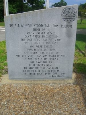
[Center Panel]:
“By your courage in tribulation, by your cheerfulness before the dirty devices of this world, you have won the love of those who have watched you.”
- Guy Chapman
Dedicated: November 11, 1991.
[Left . . . — — Map (db m9631) WM
Near Club Road at Ocean Trail (North Carolina Route 12), on the left when traveling west.
“Currituck” is from the Algonkian word meaning “land of the wild goose.”Currituck Sound is located in Currituck and Dare Counties in Northeast North Carolina.
Currituck Sound, a brackish water estuary separated from the . . . — — Map (db m257087) HM
Near National Park Drive 0.1 miles east of Roanoke Voyages Corridor (U.S. 64), on the left when traveling east.
In Honor of the
Roanoke Island Historical Association
The eight men in this May 1931 picture are shown selecting the site for the Waterside Theatre, where they planned to produce a pageant commemorating the 350th anniversary of the first . . . — — Map (db m257630) HM
On South Water Street south of East Ehringhaus Street, on the right when traveling south.
Residents of the Albemarle Sound Region made illegal liquor long before the moonshining industry became popular in the Appalachian Mountains.
The desolate swampland in northeastern North Carolina was ideal for concealing stills. The . . . — — Map (db m276336) HM
On State Highway 12 north of Coast Guard Road, on the left when traveling north.
Hatteras Island is sometimes called a sand bar or a slender strip of sand. Despite its fragile appearance, the island has been here geologically for a very long time.
Hatteras Island is surrounded by water that can be gentle and fun. That water . . . — — Map (db m191423) HM
Near Airport Road 0.1 miles east of Old County Road, on the right when traveling east.
In 1874, the U.S. Treasury Department
extended its network of lifesaving stations to North Carolina. Employment was open to qualified men regardless of color, but it was seasonal. Pay was low. Risks were high. When the small crews were not . . . — — Map (db m257241) HM
On North Carolina Route 12 at Sunset Drive, on the right when traveling south on North Carolina Route 12.
Salvo was originally named Clarks or Clarksville. It borders Cape Hatteras National Seashore to the south. Salvo separated from the two villages to its north by a cow pen. Villagers were known for their productive island gardens and musicality . . . — — Map (db m256500) HM
On South Water Street north of Shepard Street, on the left when traveling north.
As we mark the occasion of the 100th anniversary of the women's right to vote, we honor our foremothers — the brave women suffragists around the United States who protested and picketed for their constitutional right to vote. The ratification of . . . — — Map (db m276339) HM
Thin black lines indicate changes in relevance. Between each pair of lines entries are ordered geographically but all have the same relevance.
* Inflectional forms of words are their plurals, singulars, and possessives as well as gramatical tenses and similar variations.