Corolla in Currituck County, North Carolina — The American South (South Atlantic)
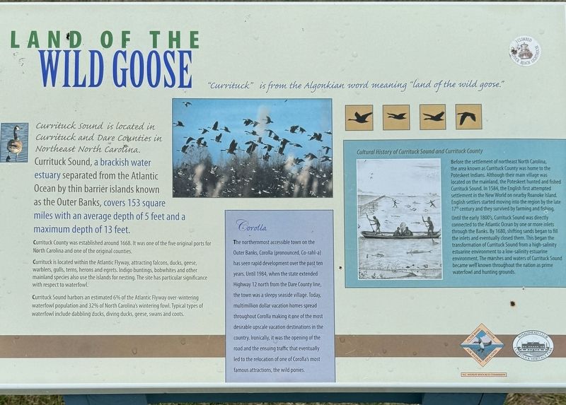
Land of the Wild Goose
Photographed by Brandon D Cross
1. Land of the Wild Goose Marker
“Currituck” is from the Algonkian word meaning “land of the wild goose.”
Currituck Sound is located in Currituck and Dare Counties in Northeast North Carolina.
Currituck Sound, a brackish water estuary separated from the Atlantic Ocean by thin barrier islands known as the Outer Banks, covers 153 square miles with an average depth of 5 feet and a maximum depth of 13 feet.
Currituck County was established around 1668. It was one of the five original ports for North Carolina and one of the original counties.
Currituck is located within the Atlantic Flyway, attracting falcons, ducks, geese, warblers, gulls, terns, herons and egrets. Indigo buntings, bobwhites and other mainland species also use the islands for nesting. The site has particular significance with respect to waterfowl.
Currituck Sound harbors an estimated 6% of the Atlantic Flyway over-wintering waterfowl population and 32% of North Carolina's wintering fowl. Typical types of waterfowl include dabbling ducks, diving ducks, geese, swans and coots.
Corolla
The northernmost accessible town on the Outer Banks, Corolla (pronounced, Co-rahl-a) has
this page online
Cultural History of Currituck Sound and Currituck County
Before the settlement of northeast North Carolina, the area known as Currituck County was home to the Poteskeet Indians. Although their main village was located on the mainland, the Poteskeet hunted and fished Currituck Sound. In 1584, the English first attempted settlement in the New World on nearby Roanoke Island. English settlers started moving into the region by the late 17th century and they survived by farming and fishing.
Until the early 1800s, Currituck Sound was directly connected to the Atlantic Ocean by one or more inlets through the Banks. By 1680, shifting sands began to fill the inlets

Photographed by Brandon D Cross
2. Land of the Wild Goose Marker
Erected by Whalehead Club Currituck Heritage Park, Outer Banks Center for Wildlife Education, N.C. Wildlife Resources Commission.
Topics. This historical marker is listed in these topic lists: Animals • Colonial Era • Entertainment • Environment • Indigenous Peoples and Communities • Parks & Recreational Areas • Settlements & Settlers. A significant historical year for this entry is 1668.
Location. 36° 22.357′ N, 75° 50.002′ W. Marker is in Corolla, North Carolina, in Currituck County. It can be reached from the intersection of Club Road and Ocean Trail (North Carolina Route 12), on the left when traveling west. The marker is located within Whalehead Club Currituck Heritage Park behind the Whalehead Club and near the Currituck Sound. Touch for map. Marker is at or near this postal address: 1100 Club Road, Corolla NC 27927, United States of America. Touch for directions.

Regionally, this marker is in North Carolina’s Coastal Plain, on the Outer Banks, and in the Hampton Roads Metropolitan Area. It is also in the American South, specifically in the Upper South, in the Tidewater, and on the Eastern Seaboard. Globally, it is in the North Atlantic Region, North America, the Western Hemisphere, the Western World, and the Anglosphere. Historically, it finds itself in what was once the territory of the Mississippian Culture, one of the original Thirteen Colonies, one of the Confederate States of America, and the Antebellum South.
Other nearby markers. At least 8 other markers are within walking distance of this marker: Ray T. Adam's Landing Strip (a few steps from this marker); The Whalehead Club Restoration (within shouting distance of this marker); Duck Blinds (about 400 feet away, measured in a direct line); The Knights (about 500 feet away); Waterfowl Resting Area (about 500 feet away); Corolla Island Bridges (about 600 feet away); First Swimming Pool on the Outer Banks (about 600 feet away); Waterfowl Hunting (about 700 feet away). Touch for a list and map of all markers in Corolla.
Also see . . .
1. Whalehead in Historic Corolla. Currituck County Department of Travel and Tourism (Submitted on September 17, 2024, by Brandon D Cross of Flagler Beach, Florida.)
2. Whalehead in Historic Corolla. (Submitted on September 17, 2024, by Brandon D Cross of Flagler Beach, Florida.)
Credits. This page was last revised on September 18, 2024. It was originally submitted on September 17, 2024, by Brandon D Cross of Flagler Beach, Florida. This page has been viewed 232 times since then and 19 times this year. Photos: 1, 2. submitted on September 17, 2024, by Brandon D Cross of Flagler Beach, Florida. • Bernard Fisher was the editor who published this page.
