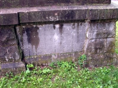
Near West Wayne Street west of South Water Street.
( Stone Base - Side 1 )
Cannon Used in War for the Unity
1861 - - 1865
Loaned by War Dept. U. S. A.
( Stone Base - Side 2 )
Dedicated to the
Union Soldiers of Owen County
By:
Gettysburg Post No. 93 G. A. R.
-and- W. . . . — — Map (db m19373) WM
On South Main Street at East Franklin Street, on the left when traveling south on South Main Street.
(Front Plaque)
In Grateful Recognition
of the
Patriotic Service Rendered by
The Men and Women of Owen County
During the World War
1917 - 1918
(Back Plaque)
This tablet is erected
in memory of these men of . . . — — Map (db m19372) WM
Near West Wayne Street west of South Water Street.
Dedicated to the Memory of Those
Who Served Their Country
During the Wars of the United States
—————————
Erected through the Efforts of
The Women's Relief Corps
of Spencer, Indiana
1939
—————————
Panel and Design of . . . — — Map (db m19401) WM
Near N. Cataract Road at Owen Park Road, on the right when traveling west.
(Side One)
An 1838 state law gave county commissioners power to build bridges for “public convenience” and to raise taxes to pay for them. Owen County Commissioners contracted 1875 for a “Smith’s High Double Wood . . . — — Map (db m74181) HM
On East Market St at South Main Street on East Market St.
Owen County formed by General Assembly, 1819. Spencer selected county seat, 1820. Neoclassical building designed by Jesse T. Johnson, Indianapolis and built by Christian Kanzler & Son, Evansville (1910-1911),was second courthouse on land donated by . . . — — Map (db m5088) HM
Near North Blackford Street north of Indianapolis Cultural Trail, on the right when traveling north.
Indiana's largest waterfall, Cataract Falls, tumbles into Cataract Lake in northern Owen County. Wolf Cave in McCormick's Creek State Park, near Spencer, provides a unique opportunity for outdoor enthusiasts. — — Map (db m238866) HM
The Cataract Covered Bridge is one of Owen County’s historic treasures. It is the only remaining covered bridge in the county. It is also only one of six Smith Truss covered bridges in the state, and one of the finest remaining examples of this . . . — — Map (db m74182) HM
Pioneer area settler John Peter Smith (1831-1901), who donated twenty acres for the establishment of this cemetery, came to Fort Worth from Kentucky in 1853. He served the community as a teacher, clerk, surveyor, and attorney, and became a noted . . . — — Map (db m264153) HM
Founded 1879 by John Peter Smith, one of Fort Worth's first settlers, who became a civic leader, mayor, philanthropist. He gave 20 acres to city; cemetery since enlarged to 100 acres. The area contains three cemeteries: Oakwood, Calvary, Trinity. . . . — — Map (db m264151) HM
On State Road 67 at N. 7th Street, on the right when traveling south on State Road 67.
History
Northern boundary of the Indiana Territory established by the 1809 Treaty of Fort Wayne between Gov. W.H. Harrison and the Indian tribes, Miami Chief Little Turtle presiding. The line followed the shadow of an upright spear at . . . — — Map (db m69993) HM
On U.S. 127 just north of State Route 607, on the right when traveling north.
Harry Clark Karsner (1914-1971).
Served Owen Court as a magistrate,
the director of First Farmers Bank,
Owen County Board of Education,
deacon Old Cedar Baptist Church,
and served as state Aeronautics
Commissioner. He flew his . . . — — Map (db m205233) HM
Thin black lines indicate changes in relevance. Between each pair of lines entries are ordered geographically but all have the same relevance.
* Inflectional forms of words are their plurals, singulars, and possessives as well as gramatical tenses and similar variations.