On SW 1st Street at West Martin Luther King Parkway, on the left when traveling north on SW 1st Street.
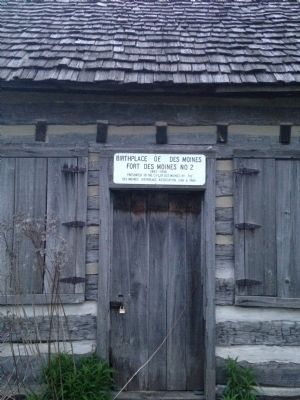
Fort Des Moines No. 2
Established May 1843 — Evacuated March 1846
This cabin is a memorial to the military outpost, Fort Des Moines No. 2, occupied by Company I, First Regiment U. S. Dragoons and Company F First U. S. Infantry. The . . . — — Map (db m84100) HM
On Pleasant Street west of 12th Street, on the right when traveling west.
People lived and worked here. They shopped and prayed here. They gathered here to celebrate life. Welcome to what was Iowa's most vibrant Black community — the historic Center Street neighborhood, stretching from 15th Street to Keosauqua Way. . . . — — Map (db m235901) HM
On East 9th Street south of Thompson Avenue, on the right when traveling south.
Born in Philadelphia, Ida B. Wise Smith rose to national prominence as a Iowan dedicated to the causes of women's suffrage, prohibition, and children's rights. Mrs. Smith pressed her causes in the political arena, achieving the enactment of a state . . . — — Map (db m235889) HM
On 4th Street NW near Market Street NW, on the right when traveling west.
This church was built by Thomas Mitchell. Thomas Mitchell was born in New Hampshire in 1816. he came to Iowa Territory in 1840, and in 1844 became the first white settler of Polk County. He built cabins and later inns to feed and shelter the . . . — — Map (db m44833) HM
On Northwest Madrid Drive at Northwest Nissen Drive, on the right when traveling south on Northwest Madrid Drive.
The Josiah & Mahala Hopkins House (1848) served the community as a post office and early stagecoach stop on the route from Fort Des Moines to Fort Dodge. It was dubbed 20-Mile House for its location 20 miles from Fort Des Moines. Locally, the . . . — — Map (db m285152) HM
On Locust Street at 7th Street, on the right when traveling east on Locust Street.
At this site where Katz Drug Store once stood, on July 7, 1948, at 3:45 p.m., Edna Griffin, her infant daughter Phyllis, John Bibbs, and Leonard Hudson entered the store and ordered ice cream at the lunch counter. The manager refused to serve . . . — — Map (db m292945) HM
Near Southwest School Street south of Southwest 3rd Street.
In the year 2000, the Ankeny Area Historical Society Board of Directors recognized the need for more space. The Marts/Neveln/McCleary house that was moved in 1995 was full of many exhibits, and artifacts were in storage.
During the . . . — — Map (db m316086) HM
On Pleasant Street at 9th Street, on the right when traveling east on Pleasant Street.
Project Partners
St. Paul's is grateful to many partners for their support of the Cathedral Rain Garden and Labyrinth. Special thank-yous go to the Iowa Department of Natural Resources, The Episcopal Diocese of Iowa, Trees Forever, . . . — — Map (db m289429) HM
Near East Court Avenue south of Dey Street, on the right when traveling east.
Ralph was a slave from Missouri. In 1834, he bought his freedom from his owner, a man named J. Montgomery, so he could come to Iowa to work in the lead mines near Dubuque. The cost of his independence was to be $550, plus interest. But after five . . . — — Map (db m236242) HM
Near North Washington Street (State Highway 87) north of River Street, on the left when traveling north.
This millstone is the last remnant of the flour mill that operated on the river bank a half-mile to the south. Power was provided by the stream that now tumbles down a rocky slope on the north boundary of the Wisconsin Interstate Park.
Pieces . . . — — Map (db m216749) HM
On East University Avenue, on the right when traveling west.
Center:
Erected in grateful remembrance of the men from Polk County, Iowa, who made the supreme sacrifice in the World War that government by the people shall be maintained and that liberty shall not perish from the earth.
(names . . . — — Map (db m316267) WM
Near George Flagg Parkway east of Fleur Drive, on the left when traveling south.
Through the centuries, the area that is today's Gray's Lake was part of the ever-changing course of the Raccoon River. Left behind after one such change in the Raccoon was an oxbow that would become Gray's Lake Park. Residents of Des Moines in . . . — — Map (db m236552) HM
On Business State Road 55 near Business State Road 341, on the left when traveling east.
Richland Township
Site of National Corn Husking Contest in 1935.
4 Blocks West - - -
Cobb Farms and L.K. Mitchell and Family Hosts.
Lawrence Pitzer of Fountain County Represented Indiana and later became National Champion in 1939. . . . — — Map (db m3405) HM
On South Pacific Highway West (Oregon Route 99W) near Bursh Grove Lane, on the right when traveling north.
(Seven panels dealing with topics related to the Applegate Trail are found at this kiosk:)
In 1846, Jesse Applegate and fourteen others from near Dallas, Oregon, established a trail south from the Willamette Valley and east to Fort . . . — — Map (db m114352) HM
Thin black lines indicate changes in relevance. Between each pair of lines entries are ordered geographically but all have the same relevance.
* Inflectional forms of words are their plurals, singulars, and possessives as well as gramatical tenses and similar variations.