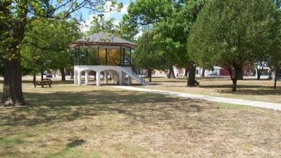
On Bridge Street at 8th Street, on the right when traveling east on Bridge Street.
Bandstand erected 1907
commemorating
50th Anniversary of Humboldt
Plaque
presented to City of Humboldt
July 4, 1976 "Bicentennial" — — Map (db m57434) HM
On Bridge Street at 8th Street, on the right when traveling east on Bridge Street.
Dedicated to the Citizens of Humboldt, Kansas, past and present, who believe the strength of a community lies in its faith in God and each other, its integrity, and its commitment to freedom for all.
Humboldt, Kansas
"A Delightful Place" . . . — — Map (db m57436) WM
On Wulf Drive near 10th Street, on the right when traveling west.
George A. Sweatt Park is named for Humboldt native, George Sweatt, born December 12, 1893. He graduated from Humboldt High School in 1912. Following military service in World War I, he attended Pittsburg State University from 1920 to 1922. A good . . . — — Map (db m57489) HM
On the East Bank [of the Neosho River], escaped slaves traveled through caves and tunnels to secret Underground Railroad stations. — — Map (db m57486) HM
On 1150th Street at Arizona Road, on the right when traveling south on 1150th Street.
In Mid-March, 1856, the first emigrants of the Vegetarian Settlement Company set out for the Neosho River Valley in Kansas Territory. Henry S. Clubb promoted Kans. Terr. as a permanent home for believers in Vegetarianism, hydropahty, and . . . — — Map (db m57499) HM
Memorial to
Veterans of All Wars
In Memory of
Vicksburg Post No. 72
Grand Army of the Republic
1861 - 1865
Lawton Circle No. 97
Ladies of the G.A.R. — — Map (db m66605) WM
On Iowa Road at 900th Street, on the right when traveling west on Iowa Road.
On November 6, 1887, Hall of Fame baseball pitcher Walter Perry Johnson was born on this farm site. In 1901, he moved with his family into the town of Humboldt. During a career with the Washington Senators from 1907 to 1927, he became famous for . . . — — Map (db m57497) HM
On Madison Avenue (U.S. 54) east of South Street, on the left when traveling west.
A.W. Beck was responsible for the development of the buildings on east Madison from Jefferson to South Avenues (viewed on the other side of this sign). Mr. Beck was an instrumental business leader from 1870 to 1928. He brought many new ideas and . . . — — Map (db m83701) HM
On Jackson Street at North Street, on the right when traveling west on Jackson Street.
This building was located at the corner of North Street and Jackson Avenue. It was torn down to accommodate the construction of a new City Hall. Although it says Andrews Auto store, it was said that he had everything, if he could find it. — — Map (db m83602) HM
On Washington Street near Madison Avenue (U.S. 54), on the left when traveling north.
Frederick Funston, five feet four and slightly built, went from this farm to a life of amazing adventure. Youthful exploring expeditions in this country were followed by two years in the Arctic from which he returned down the Yukon river 1,500 miles . . . — — Map (db m53285) HM
On Jefferson Avenue north of East Street, on the left when traveling south.
Dr. O.L. Garlinghouse was believed to be ahead of his time in his medical practice. His office was equipped with x-ray and electrotherapy and was located in the building in the photo on the other side of this sign. — — Map (db m83549) HM
On Jackson Street east of North Street, on the left when traveling east.
[Top photo caption reads]
Notice Iola's 1st horse-drawn ambulances and hearse in front of Culbertson's building. The top floor, as well as the west entrance on the bottom was used for Culbertson's mortuary business, and the east side was an art . . . — — Map (db m83588) HM
On Jackson Street at North Street, on the left when traveling east on Jackson Street.
[Top photo caption reads]
The YMCA was built in this block in 1907. It featured an indoor swimming pool, bowling alley, and various sporting amenities. The cost of upkeep led to the building being torn down.
[Bottom photo . . . — — Map (db m83599) HM
On Madison Avenue east of South Street, on the right when traveling east.
[Top photo caption reads]
This picture was taken in the early 50's looking east from the Madison Avenue and South Street intersection. Businesses on the block at that time were Cooksey Drug, JC Penney Co., Hoover Drug, Dr. Philip W. Waugh, . . . — — Map (db m83699) HM
On Jefferson Avenue north of Madison Avenue, on the right when traveling north.
EP Brigham was an entrepreneur in Iola in the late 1800s. He owned various businesses throughout Iola that sold anything from hay, to hardware, to groceries, to china. Brigham started his first business as a fresh butcher where he sold quail that . . . — — Map (db m83543) HM
On Washington Street north of West Street, on the right when traveling south.
These women were some of the first ladies of Iola. In the 1800s, they established the first Iola Public Library, located on the second floor of the L.L. Northrup Banking House.
Pictured front row: Mrs. A.W. Beck, Hazel Bowlus (Tom's sister) . . . — — Map (db m83612) HM
On Washington Street north of Madison Avenue, on the left when traveling north.
At the request of L.L. Northrup, Fred Horton came to Iola to drill the oil and gas wells of Allen County. Horton's office was located in the back of what is now the Allen County Historical Museum at the south end of this block. — — Map (db m83650) HM
On Madison Avenue (U.S. 54) west of South Street, on the right when traveling east.
George A. Bowlus started the Bank of Allen County which was the second bank in Iola, located on this block between South Street and Washington Avenue. George was one of several business men who was instrumental in paying for the trolley tracks that . . . — — Map (db m83672) HM
On Jackson Street at Jefferson Avenue, on the right when traveling west on Jackson Street.
Granny Cowden was believed to have been the 1st white woman in Kansas. You can visit her grave in the Civil War section at the Iola Cemetery west of town on Highway 54. You can also find out more about her in the Allen County Historical Museum at . . . — — Map (db m83584) HM
On Madison Avenue (U.S. 54) at Washington Street, on the left when traveling west on Madison Avenue.
[Top photo caption reads]
This photo was taken in 1910 when the Ringling Bros. Circus performers and animals paraded around town. At that time, the circus drew a huge crowd.
[Bottom photo caption reads]
This is the intersection of Madison . . . — — Map (db m83665) HM
On Jefferson Avenue at Madison Avenue (U.S. 54), on the right when traveling north on Jefferson Avenue.
Iola Colborn was the wife of Josiah Colborn, one of the founders of Iola. During a town meeting, a nomination was made to name the town after her. Mr. and Mrs. Colborn owned land from the town square to the river. Iola gave birth to the first . . . — — Map (db m83517) HM
On Madison Avenue (U.S. 54) west of Jefferson Avenue, on the left when traveling west.
This 1907 picture of the old Iola Kiosk, located on the southeast corner of the courthouse lawn, displayed weather data for many years and was also used as a town bulletin board. The structure contained about 3,300 pounds of cast iron and about 250 . . . — — Map (db m83716) HM
On Jefferson Avenue at Madison Avenue, on the left when traveling south on Jefferson Avenue.
[Top photo caption reads]
Looking west on Madison Avenue, you can see the street trolley cars and the horse and buggies. The architecture of the buildings remains the same 110 years later.
[Bottom photo caption reads]
The Iola State Bank . . . — — Map (db m83519) HM
On Jefferson Avenue south of Jackson Street, on the left when traveling south.
1859 was a monumental year for John Walter Scott. He was elected president of the 1st Iola Town Company, was a county commissioner, and was a member of the legislature. Each of the 60 plus town company members had to make a substantial . . . — — Map (db m83554) HM
On Jackson Street at North Street, on the right when traveling west on Jackson Street.
Josiah Colborn was one of the founding fathers and first businessmen of Iola. He was the husband of Iola Colborn, Iola's namesake. — — Map (db m83596) HM
On Jackson Street, on the left when traveling east on Jackson Street.
L.L. Northrup owned the first Iola bank and a huge lumber company. These businesses encompassed almost the entire block. He was instrumental in getting the railroads and financing the growth of Iola. — — Map (db m83608) HM
On Madison Avenue (U.S. 54) west of South Street, on the left when traveling west.
[Top photo caption reads]
This picture was taken standing in the intersection of South Street & Madison Avenue, looking west. Notice all the different forms of transportation represented in the picture: walking, bicycle, cars, tracks from . . . — — Map (db m83681) HM
On Washington Street north of Madison Avenue, on the left when traveling north.
Frederick Funston was born in Ohio and moved to Kansas with his parents in the spring of 1868 at the age of 2. Nicknamed "Fearless Freddy," he was of slight build - be sure to check out the life size statue in front of the Funston Home and Museum . . . — — Map (db m83656) HM
This memorial in memory of
Union soldiers who fell in battle
was dedicated on May 31, 1909, and
maintained by McCook Post No. 51, G.A.R.
In 1998 the statue was refurbished and
a new pedestal was erected. On June 2, 2001
this Monument . . . — — Map (db m34600) WM
On Madison Avenue (U.S. 54) east of Washington Street, on the right when traveling east.
Nimrod Hankins came to Cofachique, Allen County's first settlement and county seat, in 1855 when KS was still a territory. Enlisted into Company E the 9th KS Calvary [sic - Cavalry] when the Civil War broke out and rose to the rank of 1st Lieutenant . . . — — Map (db m83657) HM
On Jefferson Avenue north of East Street, on the right when traveling north.
[Top photo caption reads]
This building was owned by Dr. O.L. Garlinghouse who had a medical practice on the second floor. Notice the awnings are on the side of the building facing the afternoon sun. Air conditioning was non-existent at this . . . — — Map (db m83548) HM
On Jefferson Avenue north of East Street, on the right when traveling north.
[Top photo caption reads]
These buildings were developed after 1910. During this period, there were a number of meat markets throughout Iola. With the lack of refrigeration, people had to buy fresh meat daily.
[Bottom photo caption reads] . . . — — Map (db m83551) HM
On Jackson Street west of North Street, on the right when traveling west.
[Top photo caption reads]
On the corner is Northrup's second bank building, which replaced Northrup's Lumber Yard that encompassed most of the block. Fire destroyed the bank in January of 1949.
[Bottom photo caption reads]
On the east side of . . . — — Map (db m83606) HM
On Washington Street north of West Street, on the left when traveling north.
[Top photo caption reads]
Pictured here is Iola's 1st bank: L.L. Northrup Banking House. It was one of the 1st buildings on the square. The second story housed the 1st Iola Library.
[Bottom photo caption reads]
An early 1900s view of . . . — — Map (db m83617) HM
On Jefferson Avenue south of East Street, on the left when traveling south.
[Top photo caption reads]
East Side Cafe became Harts Lunch by the 1940s and was a local teenage hangout. Both restaurants were a favorite for homemade hamburgers and pies.
[Bottom photo caption reads]
Originally, this building had a carriage . . . — — Map (db m83545) HM
On Madison Avenue (U.S. 54) west of Jefferson Avenue, on the right when traveling east.
[Top photo caption reads]
This photo was taken looking north on Jefferson Avenue. The building on the corner was the 2nd building for the Allen County Courthouse in Iola. Notice the brick streets. Iola housed numerous brick plants during this . . . — — Map (db m83715) HM
On Washington Street south of West Street, on the right when traveling south.
[Top photo caption reads]
This view is looking north on Washington Avenue from Madison Avenue. These buildings are made of stone and wood, as many buildings were prior to the many brick plants of Iola. Notice the wood plank sidewalks. This gave . . . — — Map (db m83648) HM
On Washington Street south of Jackson Street, on the left when traveling north.
[Top photo caption reads]
T.B. Shannon is pictured on the left. He was a very innovative businessman of the times. His first business was a hardware store, which sold merchandise of all kinds. Through the years, his inventory included everything . . . — — Map (db m83610) HM
When the town of
Iola
was organized in
January, 1859
Josiah E. Colborn
was one of the founders
who named the town after
Mrs. Colburn
whose given name was
Iola
She and her husband rest here
This tablet is . . . — — Map (db m34607) HM
On Washington Street north of Madison Avenue, on the right when traveling south.
[Top photo caption reads]
This photo was taken in the 1800s of the 2 block area on the south side of the square before the first courthouse was constructed in the center.
[Bottom photo caption reads]
1900 photo is taken of a pre-celebration . . . — — Map (db m83651) HM
On Cottonwood Street, on the left when traveling north.
1917 - 1918
The American Legion
In memory of those whose final resting place
is known to God alone
U.S. Army
James E. Cook 1944 • Rex L. Johnson 1944
A. W. Redding Jr. 1943 • Joseph H. Wood 1942
U.S. Navy
Howard N. Belvoir 1942 . . . — — Map (db m72039) WM
On Oak Street north of 5th Avenue, on the right when traveling north.
National Register of
Historic Places
A Bicentennial Gift of
Four Winds Chapter, Daughters of
the American Revolution, 1974
—————————
The Anderson County Courthouse
100 Year . . . — — Map (db m89198) HM
On Main Street at 7th Avenue, on the right when traveling south on Main Street.
This ATSF caboose was located in a rail yard in East St. Louis, Illinois. It was owned by the Kansas City Southern Lines and was given to the Garnett, Kansas Lions club. The Lions with financial assistance from the Lake Garnett Racing Assn. . . . — — Map (db m89209) HM
Independence Creek was noted as the main settlement of the Kanza Tribe as far back as 1673. By the time French explorer Etienne Veniard de Bourgmont arrived in 1724 this was considered an old village and the capital of the Kanza nation.
This . . . — — Map (db m52993) HM
On River Road at Commercial Street, on the right when traveling north on River Road.
"The water we drink or the Common water of the missourie at this time, contains a half a Comm Wine Glass of ooze or mud to every pint-"
William Clark
June 21, 1804
The Missouri River of Lewis and Clark's era was wild and unpredictable. It . . . — — Map (db m44801) HM
The U.S. Army expedition led by Captains Meriwether Lewis and William Clark camped in this vicinity on July 4, 1804. In honor of the nation's 28th birthday, expedition members fired the swivel cannon on the bow of their keelboat once in the morning . . . — — Map (db m52994) HM
On River Road at Commercial Street, on the right when traveling north on River Road.
"…Capt. Lewis walked on Shore above this Creek and discovered a high moun from the top of which he had an extensive view, 3 paths Concentering at the moun..."
William Clark
July 4, 1804
The U.S. Army expedition led . . . — — Map (db m44812) HM
On Skyway Highway (U.S. 59) near 10th Street (U.S. 73), on the right when traveling west.
July 4, 1804
William Clark recorded in his
journal that on this date,
the Corps of Discovery
"Passed a Creek 12 yrs. wide...comeing
out of an extensive Prarie reching
within 200 yeards of the river, as this
Creek has no name, and . . . — — Map (db m44786) HM
On Santa Fe Street at Terrace Street, on the right when traveling east on Santa Fe Street.
Amelia Earhart was born July 24, 1897
in the home of her grandparents,
Alfred G. and Amelia Harres Otis.
The home was constructed circa 1860.
The Birthplace Museum is owned by
The Ninety-Nines, Inc. International Organization of Women . . . — — Map (db m44630) HM
On 2nd Street at Kansas Avenue, on the right when traveling north on 2nd Street.
Listed on the National Register on Feb. 1, 2002. It reflects the varied architectural tastes of Atchison's early residents. It contains a collection of architecturally significant building types dating from 1860 - 1928. — — Map (db m44633) HM
In honor of these
astronauts who perished
serving their country in space
on the Shuttle Columbia,
February 1, 2003
Rick D. Husband, Commander
Wiliam C. McCool, Pilot
Michael P. Anderson, Mission Specialist
David Brown, Mission . . . — — Map (db m47686) HM
On Skyway Highway (U.S. 59) 0.2 miles west of Rawlins Road, on the right when traveling west.
On July 4, 1804, Lewis and Clark exploring the new Louisiana Purchase, camped near this site. Fifty years later the town was founded by Proslavery men and named for Sen. D. R. Atchison. The Squatter Sovereign, Atchison's first newspaper, was an . . . — — Map (db m77888) HM
On Commercial Street near 9th Street, on the right when traveling west.
Let us hold in grateful memory
the Atchison County men who gave all
for God, Country and Humanity in the
World War 1917-1919
[Roll of Honored Dead]
Private Bryan Amend
Co. C., 140th Inf., 35th Div.
Died at Ft. Sill, Okla., Feb. . . . — — Map (db m44728) WM
At this site Atchison Leather Products operated a grease factory that filled a vital need to keep the world free. Before World War I the only factory producing a certain grease needed in munitions production and packing was in Italy. With the war . . . — — Map (db m44639) HM
To commemorate the birthplace
of
The Atchison, Topeka & Santa Fe
Railway Company in Atchison, Kansas
February 11, 1859
From this small beginning - a rail line connecting Atchison and Topeka, Kansas - a great transportation system . . . — — Map (db m44788) HM
On Commerce Street, 0.1 miles west of 2nd St, on the right when traveling east.
Text on the Front of the marker:
(picture of Concord Coach)
Butterfield's
Overland Dispatch
1865
Text on Reverse of marker:
Butterfield's
Overland Dispatch
Established 1865
by
David A. Butterfield . . . — — Map (db m99332) HM
Born in Leicester, Mass.
May 25, 1847
Died June 19, 1872
from the effect of a
railway accident.
Faithful unto death
Wisdom is the gray hair unto men
and an unspotted life is old age.
Erected by the men in the
service of the . . . — — Map (db m77749) HM
On Commercial Street at River Road, on the right when traveling east on Commercial Street.
As early as the 1600s, the Kanza (or Kaw) Indians migrated from their home east of the Mississippi River and up the Missouri River into what is now northeastern Kansas. In the 1700s, the Kanza occupied two villages on the west bank of the Missouri: . . . — — Map (db m44816) HM
On Entrance Road, 0.1 miles south of Rawlins Road, on the right when traveling south.
In memory of a soldier and statesman.
John A. Martin
Born at Brownsville, Pa. March 10, 1839.
Died at Atchison, Kas. Oct. 2, 1889.
Colonel of the 8th Kansas Volunteers, and
Brevet Brigadier General of U.S. Volunteers.
Editor & . . . — — Map (db m77740) HM WM
On 5th Street at Parallel Street, on the left when traveling north on 5th Street.
To commemorate
an address given near this corner
by
Abraham Lincoln
on "The Issues of the Day" the
night of December 2, 1859
Erected October 2, 1917 — — Map (db m44652) HM
On 8th Street at Division Street, on the left when traveling north on 8th Street.
"Put the children together, leave them alone, and they will work it out."
Dave Carey, Sr. 1955, on integrating Atchison Public Schools
The Lincoln School in Atchison, Kansas began in 1921 as the school for all African-American students . . . — — Map (db m44691) HM
On Main Street at 3rd Street, on the left when traveling east on Main Street.
On September 14, 1861 the "Central Overland California and Pike's Peak Express Co." who were the original owners and operators of the Pony Express moved their offices from the Patee House in St. Joseph, Missouri to here at the "Massasoit House." It . . . — — Map (db m44626) HM
On U.S. 73 at Osage Road, on the right when traveling east on U.S. 73.
Near here, located in a grove of young hickory trees, was an important rallying point in 1855 and 1856 for members of The Church of Jesus Christ of Latter-Day Saints (Mormon), then emigrating to the Rocky Mountains.
The campground, really a . . . — — Map (db m55363) HM
On Skyway Highway (U.S. 59) near 10th Street (U.S. 73), on the right when traveling west.
This stream was named by Meriwether Lewis and William Clark when they stopped at the present site of Atchison, Kansas on July 4, 1804. The following is an excerpt from Clark's logbook:
"...as this creek has no name, and this being the 4th of . . . — — Map (db m44784) HM
On River Road at Commercial Street, on the right when traveling north on River Road.
In 1804-06, Captains Meriwether Lewis and William Clark led about 40 soldiers and boatmen on an epic journey. President Thomas Jefferson commissioned this "Corps of Discovery" to find a route to the Pacific Ocean through the newly acquired . . . — — Map (db m44807) HM
Near this site the Atchison Town Company was formed in early July of 1854 under a large Cottonwood tree on the river.
The Lewis and Clark expedition rested and dined on corn July 4, 1804 near this same spot.
This new Cottonwood tree dedicated . . . — — Map (db m44635) HM
On Commercial Street at River Road, on the right when traveling east on Commercial Street.
Dedicated to the 1,177 men who gave their lives on the U.S.S. Arizona and all those who have bravely served the United States of America.
Billy Edwin Gibson of Atchison County is entombed in the U.S.S. Arizona.
Air raid! Pearl Harbor! . . . — — Map (db m44640) HM WM
2572 entries matched your criteria. The first 100 are listed above. Next 100 ⊳