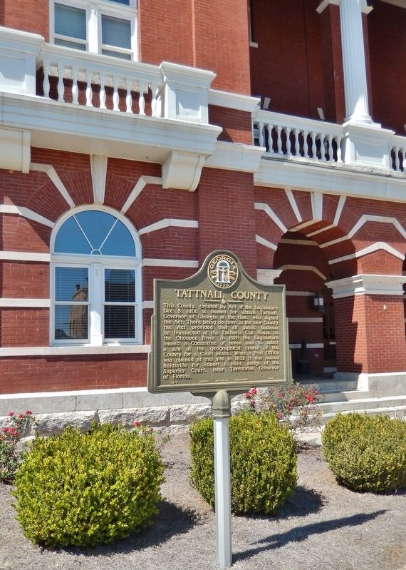
Near West Brazell Street (U.S. 280) at Church Street, on the right when traveling west.
This County, created by Act of the Legislature Dec. 5, 1801, is named for Josiah Tattnall, Governor of Georgia at the time, who signed the Act. There being no town in the new County, the Act provided that all public business be transacted at the . . . — — Map (db m170739) HM
On Madison Street near Franklin Street, on the left.
In 1889 the Darien Shortline Railroad was organized to transport yellow pine timber to the Darien sawmills from Georgia`s interior. Originating in Tattnall County and continuing through Liberty County, the Darien & Western line was completed in 1895 . . . — — Map (db m11256) HM
On U.S. 41 1.1 miles north of Oak Street (Northwest 9th Street), on the left when traveling north.
Dedicated to the memory of Michael McKenzie Smith Member State Road Department of Florida 1915-1919, Chairman 1919-1920 Born Dec. 20, 1863 Tattnall County Georgia Died July 6, 1929 Winter Park, Florida ————— He visioned and created a . . . — — Map (db m234449) HM
On West Broad Street (State Highway 46) near Nort Kennedy Street, on the right when traveling west.
Candler County was created by an Act of the Georgia Legislature July 17, 1914, out of portions of Bulloch, Emanuel and Tattnall Counties, and named for Gov. Allen D. Candler (1834-1910). Gov. Candler is famed for the preservation of Colonial and . . . — — Map (db m18229) HM
On Ada Belle Road at Old Manassas Foy Road, on the right when traveling south on Ada Belle Road.
Adabelle, named for Ada Belle Williams—daughter of J.W. Williams, was established in 1900 and a post office existed until 1907. It was a stop on the Register and Glennville Railway which connected with both the Central of Georgia Railway and the . . . — — Map (db m289524) HM
On Burkhalter Road at U.S. 80, on the right when traveling east on Burkhalter Road.
Burkhalter Road is named for the Burkhalter family (formerly spelled Burgholser), a Salzburger family that immigrated to the American colonies. In 1768, Rudolph Burkhalter was granted 400 acres of land on the south bank of the Ogeechee River . . . — — Map (db m229280) HM
On Madison Street at Franklin Street, on the left when traveling east on Madison Street.
Near this point the Darien & Western Railroad
reached its terminus in 1895 after six years
of construction. Trains arrived daily at
Columbus Square then turned around for a
return trip to Tattnall County. The D&W
later became the Georgia Coast . . . — — Map (db m11172) HM
Thin black lines indicate changes in relevance. Between each pair of lines entries are ordered geographically but all have the same relevance.
* Inflectional forms of words are their plurals, singulars, and possessives as well as gramatical tenses and similar variations.