THE HISTORICAL
MARKER DATABASE
“Bite-Size Bits of Local, National, and Global History”


7 entries match your criteria.  


South Carolina, Greenville County Historic Preservation Commission Historical Markers
 
By Brian Scott, February 7, 2011
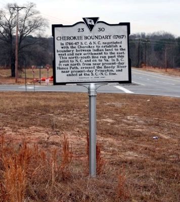
Cherokee Boundary (1767) Marker -
Front
1 ► South Carolina, Greenville County, Fountain Inn — 23-30 #2 — Cherokee Boundary (1767) —
On McCarter Drive (State Highway 418) west of Interstate 385, on the right when traveling west.
2 ► South Carolina, Greenville County, Fountain Inn — 23-45 — Fountain Inn Rosenwald School —
On Duckett Street at Mount Zion Drive (County Road 89) on Duckett Street.
3 ► South Carolina, Greenville County, Fountain Inn — 23-22 — Tullyton —
On Fairview Road (County Route 55) south of Knickerbocker Road (County Road 301), on the left when traveling north.
4 ► South Carolina, Greenville County, Greer — 23-30 #1 — Cherokee Boundary (1767) —
On South Highway 14 (State Highway 14), on the left when traveling north.
5 ► South Carolina, Greenville County, Mauldin — 23-46 — Mauldin —
On City Century Drive, in the median.
6 ► South Carolina, Greenville County, Pelzer — 23-36 — Lickville Presbyterian Church
On Augusta Road (U.S. 25). Reported missing.
7 ► South Carolina, Greenville County, Taylors — 23-39 — Tigerville —
On North Tigerville Road at Route 414 on North Tigerville Road.
 
 
CeraNet Cloud Computing sponsors the Historical Marker Database.
This website earns income from purchases you make after using our links to Amazon.com. We appreciate your support.
Paid Advertisement
Nov. 13, 2026
