7 entries match your criteria.
Related Historical Markers
By Mark Hilton, August 20, 2013
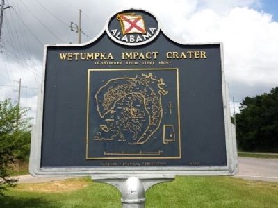
Impact Crater Area Effects
SHOWN IN SOURCE-SPECIFIED ORDER
| On U.S. 231 at East South Boundary Street, on the right when traveling west on U.S. 231. |
| On Bald Knob Road, 0.6 miles north of Enslen Drive, on the right when traveling north. |
| On Harrogate Springs Road, 1.3 miles east of Jasmine Hill Road, on the left when traveling east. |
| On Buck Ridge Road, 0.3 miles south of Harrogate Springs Road, on the right when traveling south. |
| On Trotters Trail, 0.2 miles south of Fairliewood Drive, on the left when traveling south. |
| Near Coosa River Parkway, on the left when traveling north. |
| On Orline Street west of Hill Street, on the right when traveling south. |
Jun. 17, 2024