THE HISTORICAL
MARKER DATABASE
“Bite-Size Bits of Local, National, and Global History”


7 entries match your criteria.  


Related Historical Markers

To better understand the relationship, study each marker in the order shown.
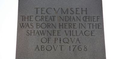
 
By Dale K. Benington, August 4, 2010
Tecumseh Marker
SHOWN IN SOURCE-SPECIFIED ORDER
1 ► Ohio, Clark County, Springfield, Shawnee Springs — General George Rogers Clark / Tecumseh —
On Tecumseh Road (Ohio Route 369) north of Lower Valley Pike, on the right when traveling north.
2 ► Ohio, Clark County, Springfield, Shawnee Springs — The Battle of Piqua, or Picawey —
Near Tecumseh Road (Ohio Route 369) 0.2 miles north of Route 4.
3 ► Ohio, Clark County, Springfield, Shawnee Springs — The Battle of Piqua — August 8th, 1780 —
On Tecumseh Road (Ohio Route 369) at Lower Valley Pike, on the right when traveling north on Tecumseh Road.
4 ► Ohio, Clark County, Springfield, Shawnee Springs — Peckuwe Shawnee Memorial —
On Tecumseh Road (Ohio Route 369) at Lower Valley Pike, on the right when traveling north on Tecumseh Road.
5 ► Ohio, Clark County, Springfield, Shawnee Hills — In Memory of Those Men Who Died in the Battle of Piqua —
Near Tecumseh Road (Ohio Route 369) north of Lower Valley Pike.
6 ► Ohio, Clark County, Springfield, Tecumseh Acres — Tecumseh — (1768-1813) —
On Tecumseh Road (Ohio Route 369) north of Route 4.
7 ► Ohio, Clark County, Springfield, Shawnee Springs — Battle of Piqua — August 8, 1780 —
On Tecumseh Road (Ohio Route 369) north of Lower Valley Pike.
 
 
CeraNet Cloud Computing sponsors the Historical Marker Database.
This website earns income from purchases you make after using our links to Amazon.com. We appreciate your support.
Paid Advertisement
Nov. 11, 2026
