On Anacostia Riverwalk Trail, 0.1 miles east of 11th Street Southeast, on the left when traveling east.
Bravery Under Fire
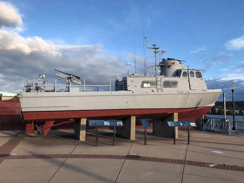
An operation that occurred on 28 January 1969 attested to the courage and quick-thinking of the young Swift Boat Sailors. Lieutenant (junior grade) John Rodgers Roland Jr., the officer in tactical command of PCF-35 . . . — — Map (db m184835) HM WM
On 4th Street Southeast at 4th Street Southeast, on the right when traveling east on 4th Street Southeast.
Almost 100 years ago, the tracks of the busy Pennsylvania Railroad freight yard known as the "Navy Yard" occupied the area around 4th and M Streets, serving the US Navy Shipyard Annex. Two or three yard engines switched freight cars that brought in . . . — — Map (db m113613) HM
On M Street Southeast east of New Jersey Avenue Southeast, on the right when traveling east.
Taxiway Guidance Sign
The colors, letters and design of standardized airport signs on taxiways and runways provide specific instructions to pilots.
Crossing Gate and Flashing Light Signal
Uniform traffic signs, sounds, signals and . . . — — Map (db m112925) HM
On M Street Southeast west of 7th Street Southeast, on the right when traveling east.
As the nation's first naval gunnery center, the Navy created its first gunnery school here in the 1850's. These "Top Gun" sailors learned how to operated and repair the Navy's largest ordnance, including 4-inch to 13-inch guns. In 1911, the Navy . . . — — Map (db m126455) HM
Near Water Street Southeast west of 4th Street Southeast, on the left when traveling west. Reported permanently removed.
Formerly the site of the Arthur Capper Senior Citizens Facility, the Bixby was completed in 2016 as part of the Arthur Capper Carrollsburg HOPE VI redevelopment and includes a mix of affordable and market rate apartments. The senior center . . . — — Map (db m141581) HM
On 2nd Street Southeast just north of M Street Southeast, on the right when traveling north. Reported permanently removed.
The Collective is a group of three highly-amenitized apartment buildings including the completed Park Chelsea and Agora, and The Garrett which is set to deliver in 2020. Long before developer WC Smith broke ground on these luxury apartments, the . . . — — Map (db m141562) HM
Near Water Street Southeast just west of 4th Street Southeast, on the left when traveling west. Reported permanently removed.
An original historic structure from the Washington Navy Yard campus, the Lumber Shed building was a concrete, open air structure that was used for the storage and drying of wood to make molds for ship construction. The building was renovated and . . . — — Map (db m141583) HM
On 9th Street Southeast at Virginia Avenue Southeast, on the right when traveling north on 9th Street Southeast.
Diagonal Virginia Avenue, SE and rectangular Virginia Avenue Park are two of the many features that characterize the L'Enfant Plan. Eventually, cut granite block paving stones were installed on Virginia Avenue, SE and most likely due to the . . . — — Map (db m136584) HM
On Anacostia Riverwalk Trail east of 1st Street Southeast.
This mural celebrates the return of the indigenous plants and wildlife to their native habitats in the Anacostia watershed. Designed and created by a group of students in the Corcoran Gallery of Art's ArtReach program. It was installed in the . . . — — Map (db m114118) HM
On Anacostia Riverwalk Trail just east of 3rd Street Southeast.
The story of the Anacostia River pulses with the same sad cycles of abuse and neglect that define the stories of rivers across America.
Our alteration of the Anacostia has affected everyone in the watershed and beyond, from the Anacostia . . . — — Map (db m184829) HM
Near New Jersey Avenue Southeast north of Tingey Street Southeast, on the right when traveling north.
Increased automobile use and interstate trucking companies spur the growth of the largest of roads in the world. Rural areas are linked to major economic centers. — — Map (db m112718) HM
Near Water Street Southeast west of 4th Street Southeast, on the left when traveling west. Reported permanently removed.
This mixed-use residential building is situated on what was formerly part of the Navy Yard annex, an expansion of the Washington Navy Yard in response to production required for Navy shipbuilding in World Wars I and II. Developed by Forest City . . . — — Map (db m141582) HM
On M Street Southeast at New Jersey Avenue Southeast, on the right when traveling east on M Street Southeast.
In Pierre L'Enfant's design for the new city of Washington, broad diagonal avenues, named after states, radiate from key buildings like the Capitol and White House. They cross the regular grid of east-west streets, identified by letters, and . . . — — Map (db m112779) HM
Near Water Street Southeast just west of 4th Street Southeast, on the left when traveling west. Reported permanently removed.
The United States Department of Transportation (USDOT) building is a two million square-feet office building that is home to the Secretary of the DOT and approximately 7,000 employees. Comprised of two office building and an underground connecting . . . — — Map (db m141579) HM
Near Tingey Street Southeast east of New Jersey Avenue Southeast, on the right when traveling west.
USS Sequoia
Presidents relax and entertain, work and negotiate on presidential yachts. The last yacht to serve, the USS Sequoia, is used by Presidents Franklin Roosevelt through Gerald Ford and was retired in 1977. . . . — — Map (db m113626) HM
On Anacostia Riverwalk Trail, 0.1 miles east of 11th Street Southeast, on the left when traveling east.
In Memory of Our Fallen Heroes
In Honor of All Swift Boat Sailors
GMG2 Billy Stanley Armstrong, 29, AR •
MRC Willy Scott Baker, 39, TN •
BM3 Richard L. Baumberger, Jr., 21, OH •
BM1 Kemper Swanson Billings, 28, NC •
BM3 Peter . . . — — Map (db m184836) WM
On H Street Southeast west of 2nd Street Southeast, on the left when traveling east.
Virginia Avenue Tunnel (1906-2015)
Virginia Avenue Tunnel
As automobile and streetcar use increased during the early 20th century, at-grade railroad crossings created safety hazards throughout the city. To address this issue, the newly . . . — — Map (db m136835) HM
Near South Capitol Street Southeast at Potomac Avenue Southeast, on the right when traveling north.
Walter Johnson
Walter "Big Train" Johnson, Washington's ace pitcher, warming up, March 1924. National Photo Company.
After a Hall of Fame career, Johnson announced Washington games on CBS radio station WJSV, including this contest . . . — — Map (db m179716) HM
Near Potomac Avenue Southeast east of South Capitol Street Southeast, on the right when traveling west.
Walter Johnson might have been the fastest pitcher in baseball history. With his sweeping sidearm delivery, the "Big Train" led the league in strikeouts 12 times during a 21 year career with the Washington Nationals from 1907 to 1927. Johnson won . . . — — Map (db m114054) HM
Near South Capitol Street Southeast at Potomac Avenue Southeast, on the right when traveling north.
Washington Baseball Club. This is a rare set of uncut baseball cards, deposited for U.S. copyright in 1887. Washington Baseball Club. New York: Goodwin & Co., 1887. Prints and Photographs Division
Bucky Harris and Fans. Washington's . . . — — Map (db m179711) HM
Near M Street Southeast at 4th Street Southeast, on the right when traveling east.
This marker is made up of five separate panels.
This historic Sentry Tower and Wall, which date to 1906, once marked the northern boundary of the Navy Yard Annex. The Washington Navy Yard, located just east of this site, has been home to . . . — — Map (db m100172) HM
On Sicard Street Southeast east of Patterson Avenue Southeast, on the right when traveling west.
This building was originally constructed as the pneumatic power plant for the forge shop in 1901. In 1962 the last gun shop closed down and the Yard began its transition from an industrial facility to an administrative and ceremonial headquarters . . . — — Map (db m10675) HM
On 8th Street Southeast north of M Street Southeast, on the right when traveling south.
The white brick wall in front of you marks the original northern boundary of the Navy Yard. The yard grew from its original 12 acres to 128 acres at its peak in 1962. In 2003 it consisted of 73 acres with 55 acres making up the adjacent . . . — — Map (db m130739) HM
On 8th Street Southeast north of M Street Southeast, on the right when traveling south.
In front of you is the main gate of the Washington Navy Yard, established in 1799. It is the U.S. Navy's oldest shore facility in continuous use. Over time, workers here have built and repaired ships and their fittings, designed and developed . . . — — Map (db m130740) HM
Near South Capitol Street Southeast at Potomac Avenue Southeast, on the right when traveling north.
Washington's Opening Game, 1925. Washington's home opener resulted in a 10-1 victory over the New York Yankees. The team went on to repeat as American League champions that season. Opening Game program, April 22, 1925. Prints and Photographs . . . — — Map (db m179712) HM
Washington Canal Park's linear rain garden, which covers the eastern portion of the park, hearkens back to the historic canal. Like the old canal, it collects stormwater. But there the comparison ends. Today's rain garden uses the latest technology . . . — — Map (db m113627) HM
On Sicard Street Southeast south of Isaac Hull Avenue Southeast, on the right when traveling north.
On display in Willard Park, named for the early 20th century commandant of the Yard, are naval artifacts from the nineteenth and twentieth centuries. Behind you is the gun mount from the battleship Maine, sunk on the eve of the . . . — — Map (db m89380) HM WM
On 8th Street Southeast at L Street Southeast, on the right when traveling south on 8th Street Southeast.
Most of the land that is now Capitol Hill—including portions of the Navy Yard – once belonged to William Prout, who lived in a large house on this block. In 1799 and 1801 he sold and traded land to the U.S. government for both the . . . — — Map (db m130742) HM
Near South Capitol Street Southeast at Potomac Avenue Southeast, on the right when traveling north.
Women Playing Baseball
a. The New York Female Giants, 1913. Bain News Baseball.
b. Rep. Ileana Ros-Lehtinen, (R-FL), the first woman in the starting lineup for the annual Congressional baseball game, Four Mile Run Park, . . . — — Map (db m179720) HM
Near Tingey Street Southeast east of New Jersey Avenue Southeast, on the right when traveling west.
Wright Brothers' 1903 Flyer
"I got on the machine at 10:35 for the first trial increasing in speed to probably 7 or 8 miles. The machine lifted..."
—Orville Wright's Diary, December 17, 1903
Lockheed Vega
Amelia Earhart . . . — — Map (db m113625) HM
Near Water Street Southeast west of 4th Street Southeast, on the left when traveling west. Reported permanently removed.
The site of Yards Park was former Navy Yard lands that were vacant and fenced off from the public since the 1890s. Yards Park now is a 5.5 acre award winning public park maintained and operated by the Capitol Riverfront BID on behalf of the DC . . . — — Map (db m141570) HM
Near Half Street Southeast just south of N Street Southeast, on the right when traveling south.
Since World War I, more than 92,000 American soldiers are unaccounted for.
This unoccupied seat is dedicated to the memory of those brave men and women and to the sacrifices each made in serving this country.
God Bless You. God Bless . . . — — Map (db m179710) WM
236 entries matched your criteria. Entries 201 through 236 are listed above. ⊲ Previous 100