108 entries match your criteria. Entries 101 through 108 are listed.⊲ Previous 100
Historical Markers and War Memorials on the North Shore Region
By Paul Fehrenbach, July 21, 2011
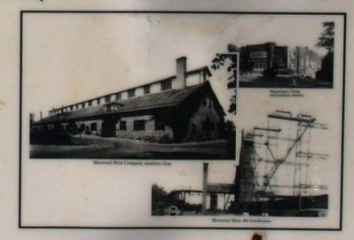
Penokee Iron Range Trail – Montreal Location Marker
101 ► Wisconsin, Iron County, Montreal — Penokee Iron Range Trail – Montreal Location — Iron County Heritage Area —  |
| You are standing in the architectural complex that supported iron mining at the Montreal Mine #5 Shaft – the heart of the mining community known as “Montreal Location.” The huge native field stone building served as the . . . — — Map (db m45411) HM | |||
| 102 ► Wisconsin, Iron County, Montreal — 77 — The City of Montreal — Site of the World’s Deepest Iron Mine — |
| The City of Montreal, incorporated in 1924, known for a short time as the Village of Hamilton, is a combination of the communities of Montreal and Gile. Gile, on the river, was the center of the area’s timber industries. The largest, the . . . — — Map (db m40932) HM | |||
| 103 ► Wisconsin, Iron County, Pence — Penokee Iron Range Trail - Plummer Location — Iron County Heritage Area — |
| Along this trail are the “ruins” of the buildings that made up the Plummer Mine Location. Each structure had a special function. Steam power, created at the boiler House, turned the Hoisting Engine. In the early 1920’s, electricity . . . — — Map (db m45417) HM | |||
| 104 ► Wisconsin, Iron County, Pence — Penokee Iron Range Trail - Plummer Mine — Iron County Heritage Area — |
| Plummer Mine Headframe Interpretive Park Dedicated to the iron miners and their families who helped build the Penokee Iron Range — — Map (db m45418) HM | |||
| 105 ► Wisconsin, Iron County, Pence — Penokee Iron Range Trail - Plummer Mine Geologic Layer Cake — Iron County Heritage Area — |
| Between 1 to 1 1/2 million years ago sediments of slate and cherty iron carbonates were laid down on top of the granite and greenstone bedrock covering this area. Molten lava flowed over the land, seeping into the great cracks on the surface . . . — — Map (db m45414) HM | |||
| 106 ► Wisconsin, Iron County, Saxon — Apostle Islands National Lakeshore — |
| Apostle Islands Scenic View You are looking out over the Chequamegon Bay region and Apostle Islands which comprises 22 Islands that form an archipelago about 30 miles long and 18 miles wide. All except one of the Islands (Long Island) are . . . — — Map (db m125029) HM | |||
| 107 ► Wisconsin, Iron County, Saxon Harbor — Flambeau Trail – Gateway to the Flambeau Trail — Iron County Heritage Area — Reported missing |
| The most popular gateway to the Flambeau Trail started here, on the shore of Oronto Bay. Also known as the “Montreal River Trail”, it was the only route inland into the dense virgin forest until the late 1880’s. The Trail was an . . . — — Map (db m45095) HM | |||
| 108 ► Wisconsin, Iron County, Springstead — Pinery Road - The Legend — Iron County Heritage Area — |
| "An old Indian legend says that Bearskull Lake is sacred. Any white man who had anything to do with the lake or its vicinity will have everlasting ill fortune." In 1904, a tornado ripped through this area, toppling the last great stands . . . — — Map (db m59484) HM | |||
108 entries matched your criteria. Entries 101 through 108 are listed above. ⊲ Previous 100