Across the canal lies the US Fish & Wildlife Service's Great Dismal Swamp National Wildlife Refuge.
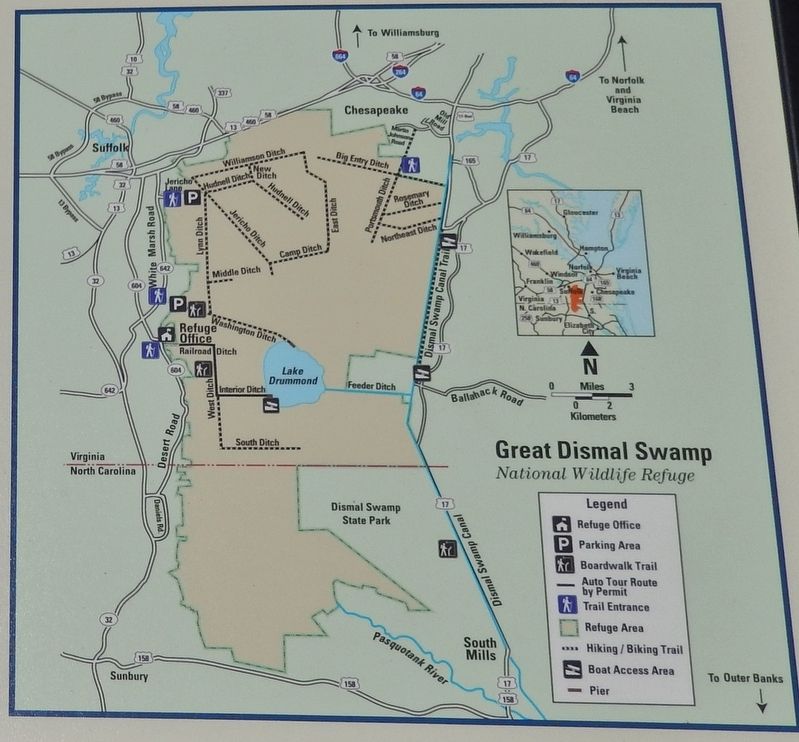
The Great Dismal Swamp was once a vast ecosystem that covered as much as one million acres of southeastern Virginia and northeastern . . . — — Map (db m114525) HM
(main legend, lower right corner) The Dismal Swamp Canal Trail, a former section of Virginia State Route 17, is now a multi-purpose, linear, nature trail and park traversing some of the most uniquely historic and ecologically significant . . . — — Map (db m114520) HM
Herring Ditch was one of many ditches that connected with the Dismal Swamp Canal. Ditches were used to transport goods to the canal, allow access to swamp timber, and provide drainage. Walter Herron, a Dismal Swamp Canal Company stockholder, began . . . — — Map (db m114521) HM
The walking path you are standing on right now has quite a history.
In 1804, it was a tow road on the eastern bank of the canal, where laborers, using long wooden poles, ropes or mules, pushed loaded barges full of shingles, lumber, corn . . . — — Map (db m114518) HM
Haphazardly scattered on the ground and under the water along the east bank of the canal, huge monoliths of chiseled stone may be waiting to be discovered. Each one found so far weighs more than 1,000 lbs. and averages 4-6 feet long. Made of . . . — — Map (db m224495) HM
Before you is the Dismal Swamp Canal, a much sought after prize of war during the Civil War. The Confederates made good use of the canal facilities during the initial stages of the conflict. A large volume of supplies passed through in both . . . — — Map (db m211247) HM
"All persons sending or carrying Boats, Goods, etc. through the Canal must not forget taking money with them to pay the toll." Norfolk Herald, January 22, 1819 The Superintendent's House, is the last standing vestige of . . . — — Map (db m224496) HM
“Glencoe,” the plantation home of Capt. William Wallace of the Jackson Grays, was located approximately one-half mile northeast of this site. William C. Wallace was born at Wallaceton, Norfolk County, Virginia, on March 23, 1842, and mustered into . . . — — Map (db m164476) HM
Approved by the Virginia General Assembly in 1818, the North West Canal was constructed by the Dismal Swamp Canal Company between 1828 and 1830. The canal was intended for carrying timber and farm products between the Dismal Swamp Canal and the . . . — — Map (db m114524) HM