On Main Street (National Road 21) at The Square, on the left when traveling north on Main Street.
His grateful fellow countrymen at home and beyond the seas have erected this monument to the memory of Rev. William Casey, for a quarter of a century prior to his death, the parish priest of this parish. He found his people struggling in the . . . — — Map (db m24739) HM
On Main Street (National Route N21) 0.1 kilometers south of the River Maigue, on the right when traveling south.
The Augustinian Friary, known as the Black Abbey, was founded in 1316 by the Earl of Kildare. It is now the Church of Ireland (Anglican) parish church and school.
The Augustinian friars first came to Dublin from England in about 1260. They were . . . — — Map (db m143072) HM
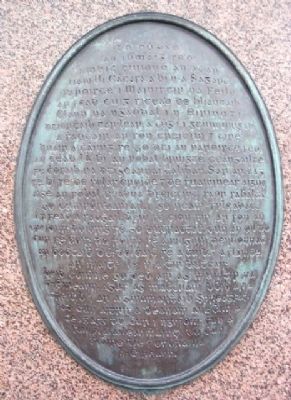
On Main Street (National Route N21) just east of Station Road (Local Route L1423), on the left when traveling east.
In grateful memory of the zeal shewn by the
people of this village in quenching a fire at the
offices of Adare Manor on the 18 April 1844
This supply of water was brought and fountain
erected by Caroline Countess of Dunraven
Lord prosper . . . — — Map (db m142967) HM
On Main Street (National Route N21) at Station Road (Local Route L1423), on the left when traveling west on Main Street.
The old town of Adare, which stood on the northern bank of the river Maigue near the castle, was destroyed during 16th century wars. Almost all of the present town was built in the 19th century.
In 1683 Thady Quin, a local landowner, leased the . . . — — Map (db m142919) HM
On Black Abbey Road (Local Route 1422) 0.1 kilometers west of Rathkeale Road (National Route N21), on the right when traveling west.
1756-1778
John Wesley, Founder of the Methodist Church visited this area on ten occasions during these years. A strong local tradition affirms that he preached under an ash tree near the ruin of the Franciscan Abbey on at least one of these . . . — — Map (db m142812) HM
On Main Street (National Route N21) just east of Station Road (Local Route L1423), on the left when traveling east.
Founded in 1230, this is the only monastery of the Trinitarian order known in Ireland. It is now Holy Trinity Abbey, Adare's Roman Catholic church.
The Trinitarian order - or the Order of the Redemption of Captives - was founded in France at the . . . — — Map (db m142969) HM
On Main Street (National Route N21) close to Station Road (Local Route L1423), on the left when traveling west.
This small pool, formed by a tributary of the river Maigue, was the traditional place for the women of Adare to wash their family clothes. It was also used as a watering place for animals.
[Illustration captions, counterclockwise from top left, . . . — — Map (db m142922) HM
On South Quay (National Route N21) just east of Lower Knockane Road, on the left when traveling east.
CAPT. DONAL SHEEHAN, Monagae, drowned at Ballykissane Pier, when going to meet the German gunship the "Aud" 20/4/1916
CAPT. CON COLBERT, Castlemahon, fought in the GPO during Easter week, executed by firing squad 7/5/1916
LT. DANIEL . . . — — Map (db m143114) HM