On Trans-Canada Highway (Provincial Highway 1) 0.3 kilometers south of Cornwall Road, on the left when traveling south.
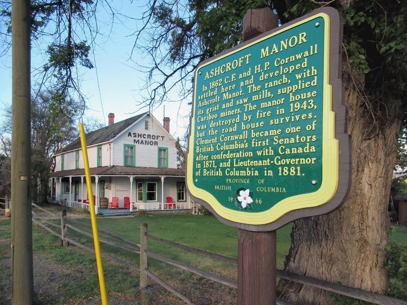
In 1862 C.F. and H.P. Cornwall settled here and developed Ashcroft Manor. The ranch, with its grist and saw mills, supplied Cariboo miners. The manor house was destroyed by fire in 1943, but the road house survives. Clement Cornwall became one of . . . — — Map (db m187921) HM
On Trans-Canada Highway (National Highway 1) 1.7 kilometers south of Venables Valley Road, on the left when traveling south.
Canada's third trans-continental rail link was completed near Basque on January 23, 1915. In a simple ceremony the last spike was driven, witnessed by a small group of engineers and workmen. The line later became part of the Federal Government's . . . — — Map (db m187813) HM
On Trans-Canada Highway (Provincial Highway 1) 0.5 kilometers east of Battle Creek Forest Service Road, on the right when traveling east.
Here bloomed a “Garden of Eden”! The sagebrush desert changed to orchards through the imagination and industry of English settlers during 1907-14. Then the men left to fight - and die - for king and country. A storm ripped out the vital irrigation . . . — — Map (db m188008) HM
On Trans-Canada Highway (Provincial Highway 1/97) 1.6 kilometers west of Battle Creek Forest Service Road, on the right when traveling west.
This is the site of an ancient lake, where 53 million-year-old fossil beds hold secrets of life in a warmer time. Preserved plants, insects and fish tell a story of early life in BC. At McAbee, climate and geology have created a treasure trove of . . . — — Map (db m187879) HM
On Trans-Canada Highway (Provincial Highway 1) 3.4 kilometers north of Holloway Drive, on the right when traveling north.
Smooth rivers and great lakes once were the highways of travel. On them plied stately paddle-wheelers, helping exploration and settlement of the Interior. They speeded gold-seekers bound for the “Big Bend” rush of 1864-65. They freighted grain from . . . — — Map (db m187961) HM
Near Dallas Drive, on the left when traveling west.
Bill Miner, notorious American stagecoach and train robber, stole $7,000 in British Columbia's first train holdup, near Mission in 1904. For two years, unsuspected, he lived quietly near Princeton, well-liked by all. In 1906 he stopped the wrong . . . — — Map (db m187878) HM
On Chief Alex Thomas Way, 0.2 kilometers south of Chief Eli Larue Way, on the left when traveling east.
The school was built in 1890, then re-built in 1923 due to a fire and remained open until 1977. In the 1920's, Native children aged 4-15 years were forcibly taken and prohibited from seeing their families, practicing their languages, cultures, and . . . — — Map (db m187877) HM
Near Columbia Street West, 0.3 kilometers west of Grandview Terrace, on the right when traveling west.
Founded in 1812, Fort Kamloops stood at a natural crossroads. For 50 years it remained the focus of an inland fur empire until the roaring mining boom of the 1860's. Ranchers, with cattle and horses, replaced the miners. They settled, and stayed, to . . . — — Map (db m188009) HM
On Southern Yellowhead Highway (Provincial Highway 5) 0.6 kilometers east of Badger Creek Road, on the left when traveling east.
It had been an epic struggle against the wilderness for the gold-seekers from Eastern Canada.
They had crossed the Rockies, trekked through pathless forests and won the swift rapids of the North Thompson River. The open country now offered hope . . . — — Map (db m187979) HM
On Princeton-Kamloops Highway (Provincial Highway 5A) 1.6 kilometers north of Long Lake Road, on the right when traveling north.
Back in the 1870's the bunchgrass hereabouts came up to a horse's belly. Some of the transient miners saw wealth in these broad rolling grasslands and swapped gold-pan for saddle. In time several “spreads” in the Nicola Valley grew to rank among the . . . — — Map (db m188013) HM