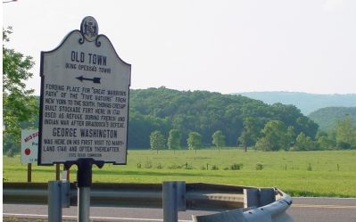
Fording place for “Great Warriors Path” from New York to the South. Thomas Cresap built stockade fort here in 1741 used as a refuge during French and Indian War after Braddock’s defeat.
George Washington
was here on his first visit to . . . — — Map (db m447) HM
The site was about one-half mile north of the river. This was one of a chain of frontier forts ordered erected by the Virginia legislature early in 1756. The chain extended from Hampshire County (now West Virginia) to Patrick County on the North . . . — — Map (db m77510) HM
What is the American Discovery Trail? The American Discovery Trail (ADT) is a project administered by the American Discovery Trail society to develop our nation's first coast-to-coast, multi-use hiking trail. It connects people to large cities, . . . — — Map (db m19342) HM
West Virginia. (Hampshire County). "The Mountain State" - western part of the Commonwealth of Virginia until June 20, 1863. Settled by the Germans and Scotch-Irish. It became a line of defense between the English and French . . . — — Map (db m309595) HM
This cemetery is centered around what is known as the Romney Indian Mound. Indian Mound Cemetery is also the site of the First Confederate Memorial, Parsons Bell Tower, and re-interments from Romney's Old Presbyterian Cemetery. The cemetery is . . . — — Map (db m150650) HM
In June 1863, Confederate Gen. Robert E. Lee ordered Gen. John D. Imboden to protect the army's left flank as it marched north through the Shenandoah Valley. Imboden was to draw Union forces into Hampshire County, West Virginia, and destroy . . . — — Map (db m253485) HM
Early in 1862, Confederate raids and attacks put Hampshire County and much of the surrounding area under nominal Southern control. The Baltimore and Ohio Railroad and nearby telegraph wires were severed, impeding Federal troop movements. A militia . . . — — Map (db m30455) HM
On May 23, 1861, Virginians voted in a statewide referendum to approve or disapprove the Ordinance of Secession that the convention in Richmond had passed on April 17. Here at the Hampshire County Courthouse, 1,188 out of 2,635 eligible voters . . . — — Map (db m58656) HM
Ezekiel (Zeke) Williams, “Grandfather of the Santa Fe Trail,” was born in Hampshire County
West Virginia, to David and Sarah Denton Williams. The family soon moved to Kentucky. He was
married in 1795 and had a son. His wife's name is unknown. Zeke . . . — — Map (db m252446) HM
Romney experienced many troop movements and skirmishes during the course of the war because of its location on the vitally important North Western Turnpike. The road linked Winchester, near the northern end of Virginia’s Shenandoah Valley, with . . . — — Map (db m261224) HM
Cacapon Mountain, where you are standing, is the westernmost of the pair of north/south mountains that mark the region as belonging to the ridge and valley section of the Appalachians. Looking out from the overlook, you see its eastern . . . — — Map (db m156764) HM
Built by State Road Comm. and local artisans in 1932; land given by H.R. Edeburn. Crystal quartz quarried from behind nearby Bloomery iron furnace, and stone from hillside behind the fountain. Spring water, gravity fed from hill above, supplied . . . — — Map (db m391) HM
Located on a 1766 Fairfax grant and
site of a former blockhouse. Built
by John Vandiver in early 19th century; soon operated as an ordinary.
Henry Trout purchased the house in
1869, repairing damage done during
the Civil War. In the latter . . . — — Map (db m92756) HM
In 1784, Washington proposed the Northwestern Turnpike as an all-Virginia route to the Ohio. Authorized in 1827 and started in 1831, it remains a monument to the skill of its engineers, Charles Shaw and Colonel Claudius Crozet. — — Map (db m4623) HM
Thin black lines indicate changes in relevance. Between each pair of lines entries are ordered geographically but all have the same relevance.
* Inflectional forms of words are their plurals, singulars, and possessives as well as gramatical tenses and similar variations.