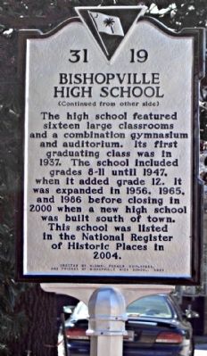
On North Main Street (U.S. 15) at East College Street, on the left when traveling west on North Main Street.
(Front text)
This high school, built in 1936, is an excellent example of a Colonial Revival school built by the Public Works Administration (PWA), a New Deal program of Franklin D. Roosevelt’s administration. Designed by architect Henry . . . — — Map (db m27915) HM
On St. Charles Road (State Highway 154) at English Lane (State Highway 31-228), on the right when traveling north on St. Charles Road.
One mile east stood the home of T.R. English, Presbyterian minister, statesman, delegate to the Secession Convention. After attending S.C. College, he was admitted to the Bar and served as a legislator, 1830-1832. Ordained in 1833, as the evangelist . . . — — Map (db m28595) HM
On Lynchburg Highway (U.S. 341) at Florence Highway (South Carolina Highway 76), on the right when traveling east on Lynchburg Highway.
Known nationally as "Cotton Ed" and active in 1905 in forming the Southern Cotton Association, Ellison DuRant Smith was elected to the U.S.Senate in 1908 and served until his death in 1944, having been Committee Chairman of Agriculture and of . . . — — Map (db m28124) HM
On Nancy Branch Road (State Highway 31-154), on the right when traveling north. Reported missing.
His home stood on this site. With his wife, Jane Bayard Wilson, he served as a Presbyterian missionary on the western coast of Africa 1833-1852. He advocated ending the slave trade and by 1844 had freed all his own slaves. Foreign Mission Secretary . . . — — Map (db m253125) HM
On West Church Street (State Highway 34) near Roland Street, on the left when traveling west.
This house is the birthplace of Thomas Gordon McLeod (Dec. 17, 1868-Dec. 11, 1932). He was the first State Senator from Lee County, 1903-1907, then Lieutenant Governor 1907-1911, and Governor of South Carolina from 1923 to 1927. His grave and that . . . — — Map (db m40683) HM
On South Main Street (U.S. 15), on the right when traveling east.
A trading center and polling place for Upper Salem in old Claremont County in the early 1800's, Bishopville was laid out on land acquired by Dr. Jacques Bishop. In 1824 a post office was established here. The town was chartered in 1888. When Lee . . . — — Map (db m27732) HM
On Gregg Street at South Main Street (U.S. 15), on the left when traveling east on Gregg Street.
(Side 1)
"Dedicated to the memory of the gallant Americans of Lee County South Carolina who gave their lives serving with the Armed Forces in World War I and II".
(Side 2)
Men of World War I who died while serving in the . . . — — Map (db m223125) WM
On Court Square (State Highway 28) south of Washington Street (State Highway 203), on the right when traveling north.
Abbeville's 6th courthouse - designed in beaux arts classical style by Edwards & Walter of Atlanta - dedicated in 1908 with City Hall/Opera House. (Two buildings indirectly financed by profits from Abbeville Dispensary, only one still operating . . . — — Map (db m14870) HM
On West Cedar Lane, on the right when traveling north.
(Front text)
Dennis High School, built in 1936, was the first high school for African-American students in Lee County. Built on land donated by philanthropist Rebecca Dennis, it was named in her honor. This school was originally intended . . . — — Map (db m27919) HM
(Front text)
William Apollos James (1857-1930), prominent local businessman and public servant, lived here from 1904 until his death. James founded the Farmers Loan and Trust Company and was its president for more than 20 years. When Lee . . . — — Map (db m28476) HM
Thin black lines indicate changes in relevance. Between each pair of lines entries are ordered geographically but all have the same relevance.
* Inflectional forms of words are their plurals, singulars, and possessives as well as gramatical tenses and similar variations.