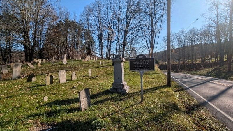
On County Route 11 0.5 miles north of County Route 14, on the right when traveling north.
Old Hartwick Village Cemetery
Has been placed on the
National Register of
Historic Places in 2013
by the United States
Department of Interior
— — Map (db m314816) HM
On Main Street (State Highway 54) just north of Maiden Lane, on the left when traveling north.
Built about 1820 in Greek Revival Style. Oliver was the 1st First Judge of Yates County, a NYS Senator, Lieut. Governor, a US Congressman & founder of the first bank in Penn Yan. — — Map (db m296388) HM
On Interstate 88, on the right when traveling north.
The Town of Worcester (pronounced WUS-ter) occupies 47 square miles in the southeastern corner of Otsego County, New York, in the divide between the Hudson and Susquehanna watersheds. It was a Mohawk Indian hunting ground when Palatines began . . . — — Map (db m220647) HM
On Washington Avenue. Reported permanently removed.
John M. Ferrell came to the Golden valley from upstate New York in June of 1859. He camped on the southeastern banks of Clear Creek and created the Washington Avenue crossing for the gold rushers. When Golden was organized, Ferrell became one of . . . — — Map (db m287883) HM
Near NY Thruway (Interstate 90) when traveling west.
Feeding an Army
A plentiful source of wheat and dairy, the Mohawk and Schoharie Valleys have long been vital farmlands. They were the targets for the British during the revolutionary War because they were important sources of food for the . . . — — Map (db m129909) HM
On Main Street (New York State Route 80) at School Street, on the right when traveling east on Main Street.
In 1807, the Skaneateles Turnpike Corporation was authorized to construct the Skaneateles Turnpike which was an East-West road beginning just east of the Village of Skaneateles and ran across southern Onondaga and Madison counties to Richfield . . . — — Map (db m253081) HM
Near N. Farmer Street south of Helen Avenue, on the left when traveling north.
Dr. Samuel Foster and his family built the first frame structure just west of here on the banks of the Kalamazoo River in the fall of 1831. First called “Allegan,” the name was changed officially to Otsego in 1835 when land developer Horace . . . — — Map (db m73761) HM
Near Old US Highway 27 South 0.9 miles north of Mancelona Road (County Highway F-38), on the left when traveling north.
Since 1922, Otsego State Park offers 62 acres and more than a half mile of sandy beach. 155 modern campsites provide the perfect family OUTDOORS vacation!
Otsego...The Name
The county was originally called . . . — — Map (db m278772) HM
Near Old US Highway 27 South 0.9 miles north of Mancelona Road (County Highway F-38), on the left when traveling north.
Since 1922, Otsego State Park offers 62 acres and more than a half mile of sandy beach. 155 modern campsites provide the perfect family OUTDOORS vacation!
Otsego...The Name
The county was originally called . . . — — Map (db m278775) HM
On Susquehanna Avenue (County Route 52) south of Walnut Street, on the right when traveling south.
Left Side:
2006
Otsego County
Ronald Tiderengal Superintendent of Highways
George Pataki Governor
Thomas Madison NYS DOT Commissioner
Earth Tech Engineer
Tioga Const. Inc. Contractor
County Road 52
Susquehanna Avenue . . . — — Map (db m253345) HM WM
On Senator Warren M. Anderson Expressway (Interstate 88) 8.5 miles west of Route 17, on the right when traveling west.
The Town of Worcester (pronounced WUS-ter) occupies 47 square miles in the southeastern corner of Otsego County, New York, in the divide between the Hudson and Susquehanna watersheds. It was a Mohawk Indian hunting ground when Palatines began . . . — — Map (db m314670) HM
On U.S. 90 0.4 miles east of Lower Sabinal Road (County Road 310), on the right when traveling east.
Established July 12, 1856 by Captain Albert G. Brackett, Second U.S. Cavalry, as a protection to the San Antonio - El Paso Road and frontier settlers • Occupied by Federal troops until November, 1856 • Later served as a Ranger camp — — Map (db m64460) HM
Thin black lines indicate changes in relevance. Between each pair of lines entries are ordered geographically but all have the same relevance.
* Inflectional forms of words are their plurals, singulars, and possessives as well as gramatical tenses and similar variations.