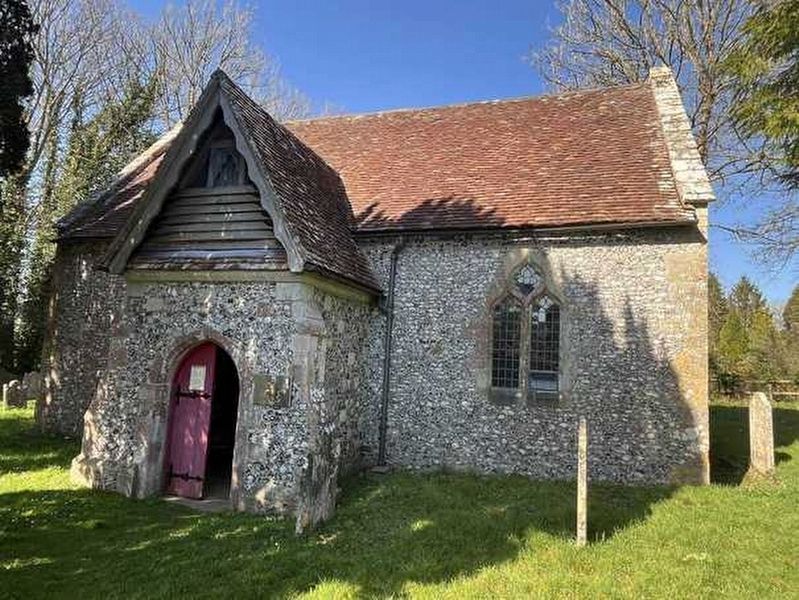
The chantry was built and endowed in 1333 by Robert de Borbach as part of the old church of St Mary. It formed the south aisle of the church and was separated from the nave of the church by a three arch arcade.
The endowment took the form of a . . . — — Map (db m271553) HM
Bridge Cottage, one of the oldest buildings in the village, had been thought to date from 1685 as shown above the front door. More recently, visiting surveyors of the Royal Commission on Ancient Monuments were of the opinion that this date might . . . — — Map (db m273185) HM
This church is a Grade II listed building. The first turf on the site was cut in 1864 and the building was completed by 1866 in which year it was consecrated by Bishop Hamilton of Salisbury on Easter Tuesday, April 3rd. The total cost was £2,578 . . . — — Map (db m272687) HM
The central part of the house was built in the second half of the 17th Century and the two wings mainly in the 18th Century with numerous alterations since. The East wing is thought to have been a Brewhouse. The stables and coach house date from . . . — — Map (db m273737) HM
The line from Bishopstoke (Eastleigh) through Chandler's Ford, Romsey, Dunbridge and Dean to Milford (Salisbury) opened for goods traffic on 27 January 1847. Passenger traffic began on 1 March 1847 and this is when the Station opened. The engine . . . — — Map (db m273978) HM
A great variety of activities took place on this site over the years. James Reynolds, who established himself as a wheelwright by 1890 and became postmaster in 1903, (see neighbouring history trail boards), was also the village undertaker. A . . . — — Map (db m273980) HM
For many years Miss Henrietta Crook lived in this house. She had a somewhat unusual occupation, perhaps best described as baby farmer or child boarding house keeper, although on the 1911 census she described herself as Nurse Domestic.
At the . . . — — Map (db m272689) HM
Roman Villa
In the fields marked on the map were several buildings. One of them also extended where the railway line and The Maltings now are. Excavations on different parts of the site were carried out in 1741, 1846 and 1871-3. The first . . . — — Map (db m275161) HM
This building was built as a milk factory. At first it was run by the Wilts and Hants Dairy Company and later became the Salisbury, Semley and Gillingham Dairy. Milk came from Winterslow, Whiteparish, the Grimsteads and the Tytherleys as well as . . . — — Map (db m273526) HM
Following the Norman Conquest in 1066, the Normans introduced these medieval fortifications into Britain and, as their forces advanced across the country, built these castles to house their garrisons and later to act as strongholds and to become . . . — — Map (db m271556) HM
In the 1920s when Mr and Mrs Bimbo Pearce lived here, Mrs Pearce kept a small shop selling tobacco, ginger beer, fizzy lemonade and sweets such as gobstoppers, liquorice and large square caramels. Sweets were sold by the pennyworth and one penny . . . — — Map (db m314495) HM
The tombstone of Henrietta Havers
In the 18th Century the former Evelyn family mansion, which stood just over the wall from the churchyard in the garden of the present house, was in use as a convent. The burial register for the parish shows . . . — — Map (db m271554) HM
The Post Office, which had previously been at Number 35, now part of Quill Cottage, was transferred to Number 1 in 1903 and James Reynolds became postmaster. In the early days Post Office letters and parcels were delivered from Salisbury each . . . — — Map (db m274375) HM
In 1938, with the threat of war looming, the Admiralty requisitioned over 500 acres of land in West and East Dean and work began on the Depot. Over three years teams of Irish miners and Scottish fitters, aided by local labourers, tunnelled 24 . . . — — Map (db m272794) HM
The signal box stood here. As you will see from the photographs, it had originally a much more decorative style than in later years.
It was manned 24 hours a day, 7 days a week by a team of signalmen most of whom lived in the Railway Cottages . . . — — Map (db m273186) HM
Tower House, instantly recognisable today by the tower which gives it its name, was not always like that. It is believed to date from the late 16th or early 17th century when it was a single storey thatched cottage. Later another floor was added, . . . — — Map (db m272695) HM
The shop was opened in 1871 by Thomas Edney. Later his daughters Phoebe, born 1860, and Caroline, born 1868, took over the running of the shop from him and it was to stay in the family for 70 years. Caroline married John Street and he joined her at . . . — — Map (db m272692) HM
This wall is all that remains of the Wesleyan Methodist Chapel which was built on this site in 1860.
In the early years of the 20th Century the chapel ran a thriving Band of Hope which the children of the village attended. In addition to hymns . . . — — Map (db m272795) HM
On this site, shown as Deane Farm on a map of 1772, are to be found no less than 6 Grade II listed buildings. The farmhouse is described in its listing as dating from the early 18th century with Flemish brickwork but this only relates to the front . . . — — Map (db m273072) HM
The school was built in 1868. The £500 building costs were paid by Thomas Baring, the then owner of the Norman Court Estate, who also provided an annual endowment of £40. It was designed to provide teaching space for 60 children and, in the attached . . . — — Map (db m273736) HM
The Wheelwright's and Blacksmith's shop stood on this site for many years.
James Reynolds, whose sign designating himself as wheelwright and shoeing smith can be seen on the side wall of Number 1 to the left, had established himself as a . . . — — Map (db m274377) HM