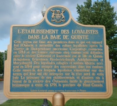
English: This region was among the first in present day Ontario to receive loyalist settlers following the American Revolution. Surveying began in 1783, and by the following year five townships had been laid out between the Cataraqui River . . . — — Map (db m83649) HM
Opposite here is the gap between Amherst Island and the eastern tip of Prince Edward County. On November 9, 1812, the British Corvette "Royal George" (22 guns), commanded by Commodore Hugh Earl(e), was intercepted off False Duck Islands by an . . . — — Map (db m83643) HM
In 1791, William Losee, an itinerant preacher, organized in this district the first Methodist circuit in Upper Canada. This Meeting House, Upper Canada's first Methodist chapel, was built in 1792. Enlarged in 1834-35 it was used for worship until . . . — — Map (db m308120) HM
Old Hay Bay Church
This simple church, built in 1792 by United Empire Loyalists, recalls the early days of Upper Canadian
settlement. The Methodists’ evangelical zeal was expressed not only in religious practice but also in their . . . — — Map (db m308110) HM
The first Preparative Meeting of the Society of Friends (Quakers) in either Upper or Lower Canada was organized in Adolphustown Township in 1798 at the house of Philip Dorland. Quakers had settled in this district in 1784 and at first held religious . . . — — Map (db m308127) HM
Originally designed in 1606, this flag was officially adopted in 1707 by England and Scotland as their royal standard at the time of the union of the thrones and parliaments of both countries. It consists of the blue background and white diagonal . . . — — Map (db m83647) HM