5 entries match your criteria.
Related Historical Markers
By Tim Carr, July 31, 2010
General Forrest’s at Johnsons Crossing
SHOWN IN SOURCE-SPECIFIED ORDER
| On County Road 31 south of Day Gap Road, on the right when traveling north. |
| | Pursuit and Union Col. Streight’s defense, from Battle Ground (26 M. - NW) to capture at Lawrence (80 M. - East) - said to be greatest cavalry fight in modern warfare. It passed here May 1, 1863. — — Map (db m33801) HM |
| On U.S. 278 at County Road 1145, on the right when traveling west on U.S. 278. |
| |
Here Gen. Forrest (C.S.A.) overtook
Col. Streight’s raiders (U.S.A.)
In hand-to-hand battle after dark 3 horses shot from under Forrest, Union force fled southward with Forrest in . . . — — Map (db m33802) HM |
| On State Highway 157 at County Road 1101, on the right when traveling south on State Highway 157. |
| | Named after a Civil War Battle fought April 30, 1863, between Confederate troops commanded by General Nathan Bedford Forrest and Union troops commanded by Colonel Abel D. Streight. Confederates lost 50 to 75 men killed or wounded. Union lost 30 men. . . . — — Map (db m33807) HM |
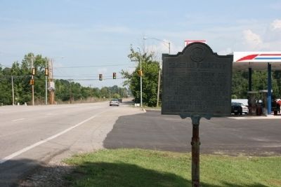
| On U.S. 31, on the right. |
| | Here Gen. Forrest (C.S.A.) overtook larger force of Col. Streight (U.S.A.)
Forrest attacked three times. Streight fled toward Rome to destroy Confederate railroad. — — Map (db m33808) HM |
| On County Road 1136, 0.4 miles north of County Road 1145, on the right when traveling north. |
| |
"This was a glorious fight, one that did the soldiers' hearts good to look upon, made there in the mountains in the darkness of the night, almost hand-to-hand, with only the light from the vivid flash of the artillery and . . . — — Map (db m101089) HM |
May. 14, 2024