6 entries match your criteria.
Related Historical Markers
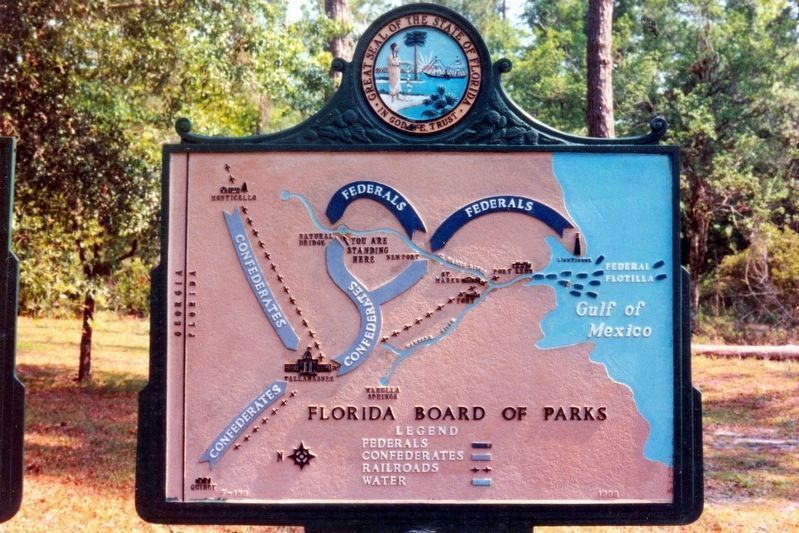
The Battle of Natural Bridge
By Tim Fillmon, December 31, 1993
Map of The Battle of Natural Bridge Marker
SHOWN IN SOURCE-SPECIFIED ORDER
| On Natural Bridge Road, on the right when traveling west. |
| | Site of decisive repulse of Federal forces by Confederate Militia in joint U.S. Army and Navy Operation to take St. Marks. The Army landing at lighthouse was prevented from getting to rear of St. Marks by Confederate opposition at Newport and . . . — — Map (db m13721) HM |
| On Natural Bridge Road, 6 miles east of Woodville Highway (State Highway 363), on the left when traveling east. |
| | (south)In Loving Memory 1861-1865 Defenders of Natural Bridge Lest We Forget (east) This monument erected under authority of an act of the legislature of Florida of 1921 as a just tribute of the people of Florida to commemorate the . . . — — Map (db m157200) HM WM |
| Near Natural Bridge Road, 6 miles east of Woodville Highway (State Highway 363), on the left when traveling east. |
| | Capturing Tallahassee was not General Newton’s primary objective even though the capital lay just eighteen miles north of St. Marks. His plan was to take St. Marks and the fort there, destroying the railroad, bridges, and other property in the area. . . . — — Map (db m157201) HM |
| Near Natural Bridge Road, 6 miles east of Woodville Highway (State Highway 363), on the left when traveling east. |
| | “Colonel Scott proceeded to place the troops in line… In the early dawn the enemy advanced in force across the pass, firing rapidly, but after a short contest were driven back by a mingled fire of musketry and canister.” ”During . . . — — Map (db m157202) HM |
| Near Natural Bridge Road, 6 miles east of Woodville Highway (State Highway 363), on the left when traveling east. |
| | Honoring the Confederate and Union Soldiers who were killed in action or later died from their wounds. Battle of Natural Bridge March 6, 1865 CSA Captain Henry K. Simmons • Cpl. Matthew B. Hawkins • J.B. Ellis • John Grubbs • Eli Triplett USA . . . — — Map (db m157203) WM |
| Near Natural Bridge Road, 6 miles east of Woodville Highway (State Highway 363), on the left when traveling east. |
| | In this area, the St. Marks River disappears into sinkholes several times and reappears as springs. Here, it flows underground through a cavern and reappears 150 feet to your right. This has formed a land bridge which has been used by wild . . . — — Map (db m157204) HM |
Apr. 29, 2024