6 entries match your criteria.
Related Historical Markers
Markers located at Lee Hall.
By Bill Coughlin, July 11, 2008
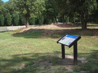
Lee Hall Marker and Earthworks
SHOWN IN SOURCE-SPECIFIED ORDER
| | The small redoubt in front of you is the only visual evidence of Lee Hall’s military occupation by the Confederate army from May 1861 to May 1862. The antebellum mansion to your right served as a headquarters building for both Maj. Gen. John . . . — — Map (db m10376) HM |
| | Lee Hall Mansion is the only Italianate antebellum plantation house on the lower Peninsula. It was completed in 1859 and was home to Richard D. Lee, justice of the peace for Warwick County. In 1850 Lee purchased a 452-acre tract of land, which was . . . — — Map (db m16547) HM |
| | Situated on high ground two miles behind the Warwick-Yorktown line, this redoubt (a four or multiple-sided field fortification) was constructed by the Confederate Army of the Peninsula. It provided a field of fire down the Great Warwick Road toward . . . — — Map (db m185336) HM |
| | In 1844, Richard D. Lee inherited 481.5 acres from his father’s estate. For the next 16 years, Lee improved and expanded his land holdings until he owned 2,100 acres. In 1860, his farm yielded 2,900 bushels of wheat, 3,500 bushels of corn, 1,400 . . . — — Map (db m16549) HM |
| | In the late seventeenth and early eighteenth centuries, Chesapeake planters moved the preparation and cooking of food from their homes to a separate structure. Thus, the odors, noise and heat from cooking were eliminated from the main house. Most . . . — — Map (db m16553) HM |
| | Unlike their ancestors who worked in tobacco fields, Warwick County slaves provided labor for raising staple crops. Slaves also cared for livestock and draft animals, worked in fields, repaired fences, washed clothes, cut wood and performed a . . . — — Map (db m16551) HM |
May. 21, 2024