On Ellsworth Avenue, 0.1 miles west of Summit Street, on the left when traveling north.
[ North face ]
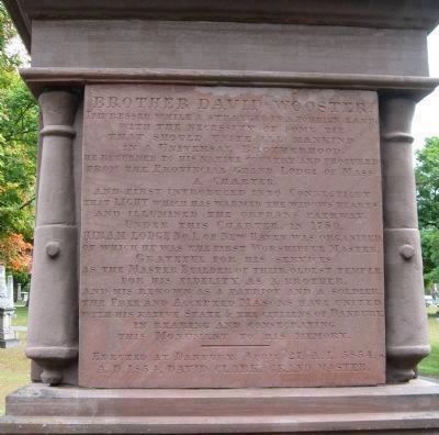
David Wooster First Maj. Gen. of the Conn. Troops in the Army of the Revolution. Brig. Gen. of the United Colonies. Born at Stratford, Mar. 2, 1710-11. Wounded at Ridgefield, April 27, 1777, while defending . . . — — Map (db m23074) HM
On Main Street at West Street, on the right when traveling south on Main Street.
Sybil Ludington
On April 26, 1777 this brave sixteen year-old girl rode through the enemy-infested countryside for thirty miles in Putnam County, New York, to warn the local militia that British troops were attacking and plundering Danbury, . . . — — Map (db m25374) HM
On Main Street at Wooster Street, on the left when traveling north on Main Street.
Eight families came from Norwalk in 1685 to settle this area which the Indians called Pahquioque. They built their first homes a half mile south of here and made this green their common. The General Court in October 1687 decreed the . . . — — Map (db m22836) HM
On Main Street at Wooster Street, on the left when traveling south on Main Street.
The revolutionary village which centered about this green with its stores of supplies for the army was sacked and burned by a force of two thousand British April 26, 1777 Warned of the gathering militia the raiders departed next . . . — — Map (db m23542) HM
On Main Street, on the right when traveling north.
In defense of American Independence at the Battle of Ridgefield April 27, 1777 died Eight Patriots who were laid in this ground companioned by Sixteen British Soldiers Living, their enemies, Dying their guests, in honor of service and sacrifice this . . . — — Map (db m23396) HM
On Main Street, on the right when traveling north.
British General Tryon’s Raid on Danbury occurred on April 26, 1777. The beginning of the 1777 campaign was the first British invasion and the only pitched battle in Connecticut. Following the burning of Danbury the British troops marched . . . — — Map (db m23412) HM
The chief engagement of Connecticut’s only inland battle during the War for Independence was fought approximately 100 yards from this site. Several hundred hastily-mustered militia joined a handful of Continental troops under Generals Benedict . . . — — Map (db m23400) HM
On Main Street at Prospect Street, on the right when traveling north on Main Street.
This town was founded in 1708 by a group of families from Norwalk who purchased twenty thousand acres from the Ramapoo Indians for one hundred pounds sterling. They were aided by John Copp, a surveyor, who explored the land now lying between High . . . — — Map (db m23409) HM
On South Compo Road (Connecticut Route 136) at Post Road East (U.S. 1), on the left when traveling north on South Compo Road.
Here occurred the first engagement between the Continentals and the British Troops when they invaded Connecticut, April - 25 - 1777 — — Map (db m21360) HM
On Compos Road South at Compos Beach Road, in the median on Compos Road South.
To Commemorate the
heroism of the Patriots
who defended their
country when the British
invaded this State April 25-
1777. General David Wooster
Colonel Abraham Gould
and more than one hundred
Continentals fell in the
engagements . . . — — Map (db m21538) HM
Near Compo Beach Road, 0.3 miles south of Soundview Drive, on the left.
To commemorate the battle fought on and
near this point between the British forces
and the American Patriots, April 28, 1777.
Ordnance presented by U.S. Government and erected July 4, 1901 — — Map (db m21550) HM