5 entries match your criteria.
Related Historical Markers
Follow the route of the 1st Transcontinental Railroad westward bound from Sacramento.
By Syd Whittle, September 10, 2008
Old Sacramento Marker
SHOWN IN SOURCE-SPECIFIED ORDER
| On 2nd Street, on the left when traveling south. |
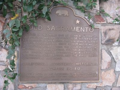
| | Founded in December 1848 by John A. Sutter, Jr., Sacramento was an outgrowth of Sutter’s Fort established by his father, Captain John A. Sutter, in 1839. State Capital since 1854, it was a major distribution point during the Gold Rush. A . . . — — Map (db m11486) HM |
| On South Manthey Road, on the right when traveling west. Reported missing. |
| | The construction of the San Joaquin River Bridge completed the last link of the Transcontinental Railroad. Building had simultaneously proceeded from the Bay Area and Sacramento and met at the San Joaquin River. The first train crossed the bridge on . . . — — Map (db m11380) HM |
| Near Kilkare Road near Main Street, on the left when traveling north. |
| | In 1869, the first Transcontinental Railroad passed this spot on its way to the shore of the San Francisco Bay. In 1984 the Southern Pacific Railroad abandoned this historic line between Niles and Tracy, California.
Volunteers of the Pacific . . . — — Map (db m63766) HM |
| Near Niles Boulevard near J Street. |
| | “May God continue the unity of our country as this railroad unites the two great oceans of the world.” The gold spike ceremony at Promontory, Utah in May of 1869 united the tracks of the Central Pacific and Union Pacific Railroads. . . . — — Map (db m143737) HM |
| On West Mall Square, on the right when traveling north. |
| | [Center and Main Marker:]
This plaque marks the terminus of the First Transcontinental Passenger train that started in New York City and terminated at Alameda Point Pier on September 6, 1869. Erected by the U.S. Naval Air . . . — — Map (db m150959) HM |
May. 4, 2024