These markers refer to Sir William Johnson; his biography, his residence, his campaigns at Crown Point, Lake George, and Fort Niagara; and his monument and grave.
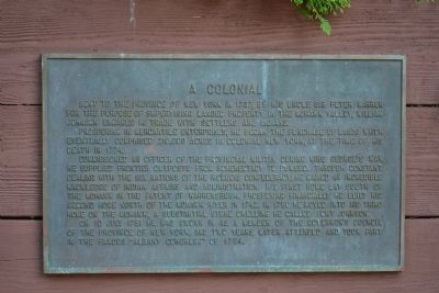
Sent to the Province of New York in 1737, by his uncle Sir Peter Warren for the purpose of supervising landed property in the Mohawk Valley, William Johnson engaged in trade with settlers and Indians.
Prospering in mercantile enterprises, he . . . — — Map (db m52124) HM
Hostilities of the Seven Years' War having commenced, Colonel William Johnson was commissioned a Major General of Provincial Forces and assigned to command the Crown Point Expedition against the French, in 1755. After the failure of the other . . . — — Map (db m52121) HM
Gaining considerable knowledge of Indian Affairs, his area of responsibility for administration reached from Hudson's Bay Canada to the Carolinas. From the Atlantic to as far west as any Indians were known.
Appointed to deal with Indians, and . . . — — Map (db m52120) HM
Sir William Johnson (1715-1774), Indian trader, statesman, diplomat and colonial empire builder. In 1763 he built Johnson Hall, the center of his estate and the scene of many Indian conferences.
Coming from Ireland in 1738, Johnson traded with . . . — — Map (db m57406) HM
Fort St. Frédéric consisted of an outer, bastioned limestone wall enclosing the Citadel, a four-story, eight-sided tower with walls twelve feet thick at the base. Cannon were mounted on each floor of the Citadel, and entry was gained by a . . . — — Map (db m11415) HM
In September 1755, a Colonial army commanded by Major General William Johnson camped on this location in preparation for an advance against the French Fortress of St. Frederic at Crown Point on Lake Champlain. On September 8, a French force . . . — — Map (db m16035) HM
In the State Park to the left are the ruins of old Fort George. About here in 1755 the French under Baron Dieskau were defeated by the British Colonials under Sir William Johnson. — — Map (db m9413) HM
Camp, Row, Camp
Campaigns in the North American wilderness required extensive planning and massive manpower to reach the objective safely and successfully. For Prideaux's army, the distance from Fort Stanwix to Fort Niagara . . . — — Map (db m75670) HM
Lakeside Camp. Prideaux's army encamped here at Sodus Bay on the evening of July 1st, 1759. They were formed on the lake the following morning by 6:00 to continue their expedition. Each boat was numbered and each man, whether officer or . . . — — Map (db m79631) HM
British forces under Brig. Gen John Prideaux and Sir William Johnson landed at mouth of 4 Mile Creek, July 6, 1759. Besieged Fort Niagara. — — Map (db m79641) HM
In July 1759, 2,300 British and New York troops, with about 900 Iroquois allies laid siege to French-held Fort Niagara. 19 days later, with its wall breached and a French relief force defeated only a mile away, Fort Niagara surrendered. . . . — — Map (db m67473) HM
A man of strong character. A colossal pioneer. One of the greatest men of his time. Sole superintendent and faithful friend of the Six Nations and their Allies. Their Warragiyaey. Founder of Johnstown. He established here the first free school in . . . — — Map (db m57754) HM
Grave of Sir William Johnson
Baronet
1715 - MASON - 1774
His Indian name
Warraghiyagey
"he who does much business"
Founder of
Johnstown
St. John's Episcopal Church
St. Patrick's Lodge 4 F.&A.M.
First Free School
Supt. of Indian . . . — — Map (db m54281) HM