16 entries match your criteria.
South Carolina, York County Historical Commission Historical Markers
By Michael Sean Nix, November 14, 2009
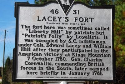
Lacey's Fort Marker
GEOGRAPHIC SORT Title Sort Marker Number Sort Marker Number Sort N Marker Number Sort T Publication Order Sort Publication Order Sort A Erected Year Sort Most Viewed Sort Most Recent-Interest Sort Most Recently Changed Sort SEE FAQ #33 FOR DESCRIPTIONS
On West McConnell's Highway (State Highway 322) at Blanton Road, on the left when traveling east on West McConnell's Highway.
On Kings Mountain Street at North Main Street, on the left when traveling east on Kings Mountain Street.
On South White Street at Main Street, on the right when traveling north on South White Street.
On Wylie Avenue at Wilkerson Street, on the left when traveling south on Wylie Avenue.
On Chester Highway (U.S. 321) at McConnells Highway (State Highway 332), on the left when traveling north on Chester Highway.
On Ebenezer Road (State Highway 274) at North Herlong Avenue (State Highway 728), on the right when traveling north on Ebenezer Road.
On College Avenue at Sumter Avenue, on the left when traveling north on College Avenue.
On Strait Road, 0.3 miles south of Saluda Road, on the right when traveling south.
On York Street at Bell Avenue, on the left when traveling north on York Street.
On Main Street, 0.1 miles west of Nimitz Road, on the right when traveling east.
On South Congress Street (U.S. 321), on the right when traveling north.
On Kings Mountain Street (State Highway 321).
On South Congress Street (Business U.S. 321) at Sharon Road (Pinckney Street) (State Highway 49), on the right when traveling north on South Congress Street.
On Hands Mill Road, 0.3 miles north of Campbell Road, on the right when traveling north.
Paid Advertisement
On South Congress Street (Business U.S. 321) just south of West Liberty Street (State Highway 161/5), on the right when traveling south.
May. 2, 2024